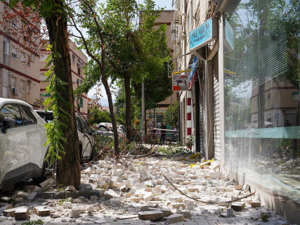
Granada registers a new earthquake of magnitude 3.1 northeast of Churriana de la Vega

A new tremor, registered at 9:54h, is felt again in the metropolitan area of Granada, according to the IGN.

2 minutes

fotonoticia 20260825144342 1920

fotonoticia 20260825144342 1920

Add DEMÓCRATA to Google

Ask FREN

Published

Last updated

2 minutes

Most read

Granada has registered a new earthquake of provisional magnitude 3.1 this Wednesday. The National Geographic Institute (IGN) has located the epicenter northeast of Churriana de la Vega, with an initially estimated depth of five kilometers. The movement occurred at 9:54 in the morning, according to the official peninsular time corresponding to the IGN record. The agency indicates that the magnitude calculation is provisional, so the data may be revised later.

The new earthquake is added to the activity that has kept the metropolitan area of Granada with numerous low-magnitude movements since August 14. The series has a special impact in the surroundings of Alhendín, Gójar, and La Zubia, south of the capital. The latest report from the IGN placed the number of registered earthquakes at 1,693 within this series up to September 7. Of them, 150 had been felt by the population, according to the data collected by the agency.

Most of the movements had magnitudes below 2 and occurred at very shallow depths, less than ten kilometers. The IGN had then counted twelve earthquakes of magnitude equal to or greater than 3 within the series. The activity has continued over the past few weeks. The IGN's own record includes, among other recent movements, earthquakes located in the surroundings of Churriana de la Vega, La Zubia, Gójar, Armilla, and other localities in the metropolitan area.

Two earthquakes of 4.8 marked the episode

The two largest magnitude movements of the series occurred on August 15 and 18, both with a magnitude of 4.8. The first had its epicenter in the surroundings of Alhendín and the second in the area of Gójar.

Both were widely felt and were perceived in more than 500 localities, mainly in central and eastern Andalusia, although also in points of Murcia, Castilla-La Mancha, and the Community of Madrid. The IGN established a maximum observed intensity of V-VI on the EMS-98 scale in populations of Granada for both.

After those two main earthquakes, several aftershocks of magnitudes 3.9, 4.2, and 4.0 were recorded on August 18, in addition to another movement of magnitude 3.7 recorded on the 14th. The series also included an earthquake of magnitude 3.6 on July 26 southwest of Armilla, prior to the start of the series counted since August 14.

More key points, information and questions with FREN

AI-GENERATED CONTENT

What protocols must the municipalities of Granada follow in the event of a seismic series according to Civil Protection regulations?

The municipalities of the province of Granada are in an area of significant seismic hazard according to the Basic Guideline for Civil Protection Planning against Seismic Risk (CM Agreement 7‑4‑1995, amended by Resolution of 17‑9‑2004) and the State Civil Protection Plan against Seismic Risk (Resolution of 29‑3‑2010). Together with Law 17/2015, of the National Civil Protection System, Andalusian Law 2/2002 on Emergency Management (amended by Law 2/2023), and Andalusian Decree 197/2024 on the Local Civil Protection System, they define a clear set of obligations and protocols for municipalities in the event of a seismic series.

1. Mandatory prior planning at the municipal level

According to Law 2/2002 and Law 17/2015, municipalities participate in civil protection with general planning and action capacity. For Granada, where seismic risk is expressly contemplated in the Basic Guideline, this implies:

  • Having a Municipal Emergency Plan (PEM) that integrates seismic risk, aligned with the Andalusian Civil Protection Territorial Emergency Plan and the Special Plan against Seismic Risk of the community, when it exists.
  • Creating the municipal civil protection structure (Local Civil Protection Service regulated by Decree 197/2024), with technical personnel and clearly defined command channels.
  • Developing and keeping updated the catalog of mobilizable resources (art. 26 Law 2/2002): vehicles, machinery, rescue equipment, shelters, etc., and the catalog of elements at risk (notable buildings, critical infrastructures, schools, health centers, residences...).
  • Establishing interface procedures for the activation of higher-level plans (Andalusian Territorial Plan and State Plan), as well as operational connection with 112-Andalusia and the Emergency Coordination Center (CECEM).
2. Activation of the Municipal Plan and emergency levels

The State Seismic Risk Plan and Law 17/2015 distinguish between territorial plans (autonomous and local) and special plans (including earthquake plans). In the event of a seismic series in Granada, the municipality must:

  • Declare the emergency situation and activate the Municipal Emergency Plan, at the appropriate level (alert, pre-emergency, local emergency), depending on the intensity of the earthquakes, observed damage, and warnings from technical services (IGN, Civil Protection, etc.).
  • The mayor, as the highest municipal civil protection authority (art. 26.2 Law 2/2002), assumes the direction of the local emergency, being able to request reinforcements and the activation of higher-level plans.
  • Constitute the Local Operational Coordination Center (CCOL) provided for in Andalusian regulations, as a municipal command post connected with CECEM-112 and, if applicable, with the Integrated Operational Coordination Center (CECOPI) if the Junta and the State assume direction.
  • Participate in the sectorization of the affected area and in the installation of Advanced Command Posts (PMA), according to the integrated operational command model of the State Plan, when the emergency exceeds the strictly local scope.
3. Information, self-protection, and measures regarding the population

Both Law 17/2015 and Law 2/2002 reinforce the citizens' right to information and the municipal obligation of prevention. During a seismic series, the PEM must foresee that the municipality:

  • Issues clear and coordinated warnings and instructions (do not use elevators, safe meeting points, traffic cuts, etc.), using all available channels: website, institutional social networks, loudspeakers, local media.
  • Activates self-protection plans in municipal buildings and centers where the municipality has competencies (public schools, sports facilities, civic centers), verifying that their managers apply the evacuation and confinement protocols provided in the basic self-protection regulations.
  • Organizes and marks refuge and provisional shelter areas for population displaced by housing damage, with support from the Junta de Andalucía and, if applicable, the State.
  • Coordinates with security forces and health services the prioritization of rescues, care for the injured, and protection of vulnerable groups.
4. Critical infrastructures, damage, and rehabilitation

The Basic Seismic Guideline and the State Plan require identifying critical elements and providing for their protection. In application of this framework, the municipality must:

  • Immediately review the condition of municipal infrastructures: water networks, sanitation, lighting, local roads, public buildings, educational and health centers of local ownership.
  • Inspect potentially damaged buildings (especially those cataloged as of special importance in the municipal inventory), marking dangerous areas and, if necessary, ordering evacuations and shoring.
  • Prepare a preliminary damage and needs assessment to be forwarded to the Granada Provincial Council, the Junta, and the Government Subdelegation, for the mobilization of external aid and resources.
  • Plan the rehabilitation and return to normality phase: progressive restoration of services, psychosocial support, cleaning and debris removal, and review of urban planning in light of what occurred.
5. Inter-administrative coordination and volunteering

Finally, Law 17/2015 and Andalusian regulations emphasize cooperation:

  • The municipalities of Granada must make their resources and services available to the autonomous and state civil protection system, integrating into the Local Civil Protection System regulated by Decree 197/2024.
  • They can collaborate through supra-municipal entities and agreements, including the Provincial Council, to share civil protection and firefighting resources.
  • They must organize and incorporate local civil protection volunteers according to specific regulations, for support tasks in information, logistics, shelter, and rehabilitation, never replacing essential professional services.

In summary, in the event of a seismic series, the municipalities of Granada are legally obliged to activate and apply their municipal emergency planning, under the direction of the mayor, fully coordinated with the Andalusian and state civil protection system, always prioritizing the protection of life, truthful information to the population, and the rapid rehabilitation of the territory.

What are the competencies of the National Geographic Institute in monitoring and managing earthquakes in Spain?

The National Geographic Institute (IGN), attached to the Ministry of Transport and Sustainable Mobility, is the state reference body in Spain for seismic monitoring and technical information on earthquakes, although it does not direct the emergency nor the operational decisions of civil protection. Its competencies focus on detecting, analyzing, and communicating seismic activity and on developing the scientific basis for planning and regulation.

1. Seismic monitoring and earthquake detection

According to Royal Decree 253/2024, included in various agreements published in the Official State Gazette (BOE) (for example, the IGN–AEMET agreement of 2025, text in the BOE), the IGN has, among others, the following functions directly related to earthquakes:

  • Planning and managing seismic movement monitoring systems nationwide, including operating the National Seismic Network, which continuously records and processes seismic activity.
  • Detection, location, and calculation of seismic parameters: it is the body responsible for officially determining magnitude, epicenter, depth, and intensity of each earthquake recorded in Spain, as summarized in the divulgative analysis by Demócrata (“Earthquakes in Spain: Who does what in the event of a quake”).
  • Official cataloging of seismic activity: the IGN maintains and updates the national earthquake catalog and maps of historical and recent seismicity, which serve as the basis for risk studies and technical regulations.
  • Participation in international seismological networks, providing data and receiving information that improves detection of regional and distant earthquakes that may affect Spain.
2. Information and technical alert to institutions

The same regulatory framework assigns the IGN the planning and management of monitoring, communication, and alert systems to institutions about seismic movements occurring nationwide (IGN–AEMET agreement). This translates into several practical competencies:

  • Quickly transmitting to emergency and civil protection centers the parameters of each earthquake (time, location, magnitude, depth, felt intensity).
  • Providing technical and interpretative reports on the evolution of seismic sequences (for example, if aftershocks predominate, if the series concentrates on a specific fault, etc.), which authorities use to adjust alert phases and self-protection measures.
  • Offering public information services, such as the near real-time map of “Latest Earthquakes” and the “IGN Earthquakes” app, mentioned on the Electronic Administration portal (CNIG applications).

In practice, during episodes like the recent seismic series in Granada, Demócrata and official notes record that the IGN is the official reference to know “where it shakes, with what magnitude and at what depth,” but it does not decide evacuations, infrastructure closures, or emergency plan phases. That responsibility lies with autonomous communities, municipalities, and, if applicable, the Ministry of the Interior.

3. Planning, hazard maps, and regulations

Beyond immediate monitoring, the IGN has key structural functions:

  • Coordination of the National Plan for seismic, volcanological, and other geophysical phenomena monitoring, approved by the Government in 2025 and developed by the IGN itself (Ministry of Transport note). This plan sets measures to strengthen networks, improve detection and communication systems, and coordinate administrations.
  • Updating the national seismic hazard map, a central tool for designing seismic-resistant construction regulations and emergency planning. Demócrata notes that these maps allow estimating where it is more likely to exceed certain ground acceleration levels and serve as the basis for safety requirements of buildings and infrastructures.
  • Preparing reports on seismic-resistant construction regulations, providing technical advice in reviewing building codes and related regulations.
  • Conducting scientific work and studies on seismicity and seismic risk, often in collaboration with universities and other public research bodies.
4. Role in emergency management

In terms of “management” of earthquakes, its competence is mainly scientific and supportive:

  • Providing data and analyses to Civil Protection and seismic risk advisory committees, which decide plan activations, evacuations, and restrictions.
  • Collaborating in drills, scenario planning, and advising administrations.
  • Integrating its monitoring systems into broader alert devices (for example, the National Tsunami Alert System, where the National Seismic Network, dependent on the IGN, is the body that detects and assesses potentially tsunamigenic phenomena, according to the agreement published in the BOE BOE-A-2025-22841).

In summary, the IGN is the technical and scientific core of the Spanish seismic risk management system: it monitors and analyzes earthquakes, maintains hazard maps, coordinates seismic monitoring at the state and international level, and provides essential information for civil protection authorities to make informed decisions.

Which other autonomous communities have experienced similar seismic series in the last decade?

With the information provided by the sources consulted in this search, it is not possible to reconstruct a complete list, community by community, of all relevant seismic series or swarms in Spain in the last decade. However, some cases are clearly identified and, above all, the areas of the country where autonomous administrations are specifically preparing for a risk of recurrent seismicity.

What is meant by a "seismic series" or "swarm"

In the terminology used by the National Geographic Institute (IGN) and Civil Protection services, a "series" or "seismic swarm" refers to the occurrence of multiple earthquakes of generally moderate or low magnitude, concentrated in the same area and within a relatively short time interval (days or weeks). This pattern differs from a single isolated earthquake followed by some aftershocks, because in swarms there may not be a clearly dominant main event.

From the perspective of public management, these episodes are relevant because:

  • They generate social concern as the tremors repeat over several days.
  • They require intensified monitoring by the IGN and autonomous emergency services.
  • They serve as a reference to update Civil Protection plans and self-protection protocols.

Andalusia: seismic series in the Vega de Granada

The only "seismic series" explicitly cited in the official notes located is that of the Vega de Granada, in the autonomous community of Andalusia.

A note from the Junta de Andalucía on emergency training for architects indicates that, following that seismic series, the 112 Emergency Coordination Center prepared two educational guides on how to protect oneself against seismic risk (one for adults and another for children), available on the Presidency Department's website. This document highlights that the experience of that particular series has motivated:

  • The creation of provincial groups of architects expert in post-earthquake damage assessment.
  • The standardization of damage assessment protocols in buildings.
  • The development of specific outreach materials on seismic risk for the population.

In other words, Andalusia, and particularly the Granada area, is recognized as one of the zones where recent seismic series with sufficient impact have occurred to reorient the autonomous civil protection policy against earthquakes.

Galicia: specific planning against earthquake risk

In the case of Galicia, the Xunta has revised its Special Civil Protection Plan against Earthquake Risk (SISMIGAL), according to an official note consulted. It indicates that the plan includes:

  • Risk analysis with detailed territorial information by zones.
  • Characterization of seismic hazard and vulnerability.
  • Organizational structure for the management and coordination of earthquake emergencies.

Although this document does not explicitly mention a specific "series" or "swarm" in the last decade, having an updated specific plan indicates that Galicia is considered by its authorities as a community with seismic risk to be taken into account, and that it prepares for repeated tremor episodes, even if they are of moderate magnitude.

Canary Islands: seismic monitoring linked to volcanism

Another relevant reference in the sources consulted points to La Palma (Canary Islands). A statement from the Ministry of Transport about the minister's visit to the IGN facilities on the island highlights that this center is "key to monitoring the evolution of emissions after the 2021 Cumbre Vieja eruption."

Although that text focuses on volcanic emission monitoring, the experience of the 2021 eruption was preceded, as described by scientific bodies, by intense repeated seismic activity in the area. It is reasonable to interpret that the Canary Islands, particularly islands with recent volcanic activity like La Palma, constitute another territorial scope where seismic swarms linked to volcanism have had relevance in recent years.

Limits of accessible information and how to obtain a complete map

Beyond these cases, it is important to underline a methodological limit: the sources accessed in this search (notes from autonomous governments, ministries, and general IGN descriptions) do not offer an exhaustive list by autonomous community of all swarms or seismic series recorded between 2014 and 2024.

To obtain a complete map of communities that have experienced similar seismic series in the last decade, the most rigorous procedure would be:

  • Use the IGN Earthquakes service, which offers the catalog of located quakes in Spain, filtering by date and geographic area to identify temporal concentrations of events.
  • Cross-check those data with the special civil protection plans of each community (Andalusia, Galicia, Canary Islands, etc.), which usually include hazard analyses and references to recent historical episodes.
  • Review press releases from autonomous emergency services (112) when they activate information campaigns linked to repeated tremor episodes.

In summary, with the data available here it can be stated that Andalusia (Vega de Granada) has suffered at least one recent seismic series significant enough to generate specific protocols and materials, and that Galicia and Canary Islands are preparing for seismic risk that includes potentially repetitive episodes. For a detailed enumeration of "all" communities affected by swarms in the last decade, it is essential to directly exploit the IGN catalog and autonomous plans, beyond the specific references provided by these notes.

Play

Test your knowledge with FREN!

How much do you know about this topic? Answer the following 3 questions.

What was the magnitude of the new earthquake recorded in Granada northeast of Churriana de la Vega?

Question 1 of 3

How many earthquakes of magnitude 3 or higher has the IGN recorded within the seismic series up to September 7?

Question 2 of 3

On which dates did the two largest magnitude earthquakes recorded in the Granada seismic series occur?

Question 3 of 3