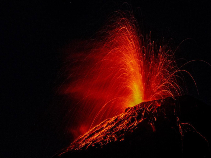

Guatemala has preventively evacuated about 250 people due to the intensification of the eruption of the Fuego volcano. Authorities have declared an orange alert and keep National Route 14 closed due to the descent of pyroclastic flows through several of its ravines.
Guatemala evacuates 250 people due to the Fuego volcano
Guatemalan authorities have begun to transfer families residing in the areas closest to the Fuego volcano, one of the most active in Central America, to temporary shelters.
The first confirmed evacuations affect the hamlet of El Porvenir and the village of Las Lajitas, both in the municipality of San Juan Alotenango, in the department of Sacatepéquez. The National Coordinator for Disaster Reduction —CONRED— estimates that about 50 families, around 250 people, have preventively abandoned their homes.
The volcano enters a more intense eruptive phase
The National Institute of Seismology, Volcanology, Meteorology and Hydrology —INSIVUMEH— detected changes in the behavior of the volcano since Sunday afternoon. Activity intensified on Monday, with emissions of gases, ash, and incandescent material.
The agency has recorded pyroclastic density currents, mixtures of gas, ash, and rocks at high temperatures that descend rapidly down the slopes. These flows have advanced through five ravines and could cover a greater distance if explosiveness increases.
Images released from the area show a lava fountain between 200 and 300 meters above the crater. The ash column has reached about 5,000 meters above sea level and is moving mainly to the west and northwest.
The ash could reach areas located 100 kilometers away
Authorities warn that the dispersion of ash could affect municipalities located up to 100 kilometers to the west and northwest of the volcano, especially in the departments of Chimaltenango, Suchitepéquez, and nearby areas.
CONRED has declared an orange alert and has asked the communities of Sacatepéquez, Chimaltenango, and Escuintla to remain attentive to official instructions and prepared for new evacuations.
Tourist access to the Fuego and Acatenango volcanoes remains restricted until further notice. Authorities have warned of the risk of approaching the crater or remaining in the ravines where pyroclastic flows, avalanches, and lahars may descend.
Preventive closure of National Route 14
The National Route 14 has been closed preventively in the vicinity of San Juan Alotenango. The descent of volcanic material down the Las Lajas ravine affects points close to the road, one of the main communication routes in the area.
The Ministry of Education has also suspended classes in the communities near the volcano, while emergency services are preparing temporary shelters and evacuation routes.
The background of the 2018 eruption
The Fuego volcano is located about 40 kilometers southwest of Guatemala City. Its most severe eruption in recent years occurred in June 2018, when pyroclastic flows buried several communities and caused more than 200 fatalities, in addition to numerous missing persons and thousands of evacuees.