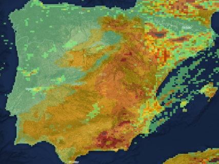

The wildfire map of this Tuesday, August 25, reflects a situation of greater stability after the major emergencies of the last weeks. The fire in Pinofranqueado, in Las Hurdes, has been declared controlled and the level of danger has been lowered, while the fire in Segorbe, in the Sierra Calderona, remains stabilized.
The main devices are now maintaining surveillance, cooling, and consolidation work on the affected perimeters. The map also includes other recent fires that remain under monitoring in Aragón and the Comunitat Valenciana, although none currently show an evolution comparable to that of the large fires recorded during August.
Official map of active fires from Copernicus
The European Forest Fire Information System, EFFIS, offers a public viewer to locate fires, hot spots, and burned areas in Spain and the rest of Europe.
The map allows observing the perimeters detected by satellite, but the appearance of a hot spot does not necessarily mean that there is an active wildfire. To know the official status of each emergency, the regional emergency services of 112 and firefighting must also be consulted.
Pinofranqueado is controlled in Las Hurdes
The fire in Pinofranqueado, in Cáceres, has been controlled after several days of emergency. The INFOEX Plan has lowered its danger level to zero and the latest provisional estimate places the affected area at about 3,765 hectares.
The device is maintaining surveillance work over the area while beginning a new phase focused on the consequences of the fire. Among the priorities is to ensure water supply in the affected hamlets and to prevent ashes from affecting water resources.
Segorbe remains stabilized after affecting 630 hectares
The wildfire in Segorbe, which also spread towards the municipality of Gátova, remains stabilized after affecting about 630 hectares in the surroundings of the Sierra Calderona.
The improvement has allowed lifting the confinement of the population and reopening the CV-25 road. Ground teams continue working on the perimeter to cool the affected areas and prevent possible re-ignitions, while some forest tracks and trails remain closed.
Las Peñas de Riglos maintains work on the perimeter
The fire at Las Peñas de Riglos, in Huesca, continues under surveillance after being one of the major wildfires of the month. The INFOAR operation is carrying out cooling work on the hot spots and smoke detected within the affected perimeter.
The evolution has allowed for a progressive reduction in the emergency response, although the fire still requires monitoring to prevent re-ignitions and to advance towards its definitive extinction.
Biscarrués and Aliaga continue with a favorable evolution
The fires declared over the weekend in Biscarrués, in Huesca, and Aliaga, in Teruel, remain under monitoring after their favorable evolution. The former was stabilized during the day it was declared, while the latter was reported as controlled.
The means of the Aragonese operation continue to carry out the necessary work on both perimeters to complete the extinction tasks.
La Vall d’Uixó is controlled after preventing the spread to the mountain
The firefighting teams also intervened in La Vall d’Uixó, in Castellón, due to a fire declared in the area of Camí La Punta. The fire affected abandoned farmland, but the firefighters' actions prevented the flames from reaching the nearby forest mass.
The fire was brought under control and the teams completed the review and cooling work on the perimeter, while the device maintains surveillance due to the risk of new hotspots in areas with dry vegetation.
To know the specific situation of a municipality, these sources should be used:
- EFFIS-Copernicus: satellite location, perimeters, and hot spots.
- Protección Civil: emergencies and state deployment.
- DGT: closed or affected roads.
- AEMET: daily fire risk level.
- Autonomous services of 112: official status of each fire, evacuations, and confinements.
Searcher: check the fire risk today in your municipality
Enter the name of your municipality in the searcher to know the level of wildfire risk forecasted today according to AEMET. The searcher is updated daily and shows the situation in more than 8,000 Spanish municipalities through the Forest Fire Danger Index (IPIF).
↔ Slide the table sideways to check all days.
The system classifies the risk into six levels:
- Very low.
- Low.
- Moderate.
- High.
- Very high.
- Extreme.
Each municipality appears classified according to the predominant level expected for that day.
How the fire risk map works
The search engine uses the information published daily by the State Meteorological Agency through its *Forest Fire Danger Index (IPIF).
This system combines different meteorological variables that directly influence the possibility of a forest fire starting and spreading, among them:
- Temperature.
- Relative humidity.
- Wind speed and direction.
- Accumulated precipitation.
- State of the vegetation.
With all this data, AEMET prepares a forecast map that allows estimating the level of danger existing at each point of the national territory.
What each risk level means
The index used by AEMET divides the fire risk into six categories:
- Very low* and low indicate that the meteorological conditions are not very favorable for the start of a large fire.
- The moderate level advises taking extreme caution, especially in activities that may generate sparks or flames.
- When the risk becomes high, very high, or extreme, the chances of a fire starting and spreading quickly increase considerably, especially if episodes of intense wind or very high temperatures coincide.