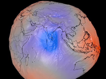
What is the geoid and why is NASA explaining again the true shape of the Earth

Beyond school maps: the science behind the geoid reveals a dynamic planet, shaped by gravitational forces that challenge our common perception.

1 minute

geoide nasa

geoide nasa

Add DEMÓCRATA to Google

Ask FREN

Published

Last updated

1 minute

Most read

Images and explanations from NASA about the real shape of the Earth have been spread again, hence the talk of the geoid. Although it is usually represented as a sphere, scientists use a much more precise model to describe its surface.

The geoid constitutes a fundamental reference for cartography, satellite navigation, and studies on sea level. NASA and other space agencies rely on it to make measurements with great precision and study how the Earth's gravitational field varies.

The geoid is not the physical shape of the planet

When talking about the geoid, one is not describing the visible aspect of the Earth, but a mathematical surface that represents the mean level of the oceans if they were only under the influence of gravity and the planet's rotation.

This surface presents small undulations and unevenness because gravity does not act with the same intensity at all points on the planet. Differences in the distribution of terrestrial mass, the presence of mountain ranges, or variations in the density of the Earth's interior cause the gravitational field to be non-uniform.

NASA uses the geoid model to improve the accuracy of measurements made by satellites dedicated to observing the Earth. Missions like GRACE and GRACE Follow-On have allowed for the creation of very detailed maps of the Earth's gravitational field and to track phenomena such as melting, the loss of groundwater, or changes in sea level.

This data is also essential for geodesy, the scientific discipline that studies the shape and dimensions of the Earth, and for numerous positioning and cartography systems used worldwide.

An image that often generates confusion

Representations of the geoid show a planet with irregular shapes and striking colors, an image that frequently goes viral on the internet. However, experts remind us that this is not a photograph of the Earth nor its real appearance seen from space.

The geoid is a scientific tool that allows us to understand how gravity acts on the planet and improve the accuracy of numerous geological, oceanographic, and climatic studies. For this reason, every time these images circulate again on social media or popular publications, interest also increases in understanding what they really represent.

More key points, information and questions with FREN

AI-GENERATED CONTENT

Which other space agencies, besides NASA, use the geoid model in their research?

The geoid model is a topic specific to geodesy and space sciences, but my area of expertise is politics and current sociopolitical affairs, especially in Spain. Therefore, I cannot provide you with a reliable and detailed list of which specific space agencies, beyond NASA, use the geoid model in their research nor provide technical information on how they use it. Any answer I tried to give you in that area would be incomplete or potentially inaccurate.

Instead of inventing data, it is important to clarify what type of information I can provide you with rigor. I am designed as a political analysis assistant in the Spanish context, focusing on the functioning of institutions, the drafting of regulations, parliamentary and governmental activity, as well as coverage of political and social current affairs by specialized media such as the newspaper Demócrata. Based on this specialization, my scope is limited to topics such as political parties, parliamentary groups, legislative initiatives, positions of political actors, public policies, or debates on science and technology when addressed from a political or regulatory perspective.

Areas where I can help you

Although I cannot technically answer your question about space agencies, I can help you if you are interested in the political or institutional component of space policy. Some examples of issues on which I can provide information are:

  • Spanish and European space policy: I can comment on decisions by the Government of Spain related to the Spanish Space Agency, Spain's participation in the European Space Agency (ESA), or parliamentary debates on investment in space programs, provided such information is found in official sources or coverage by media like Demócrata.
  • Regulatory and normative framework: I can explain what legislative initiatives exist (or have been debated) in Spain regarding sectors linked to space, such as regulations on Earth observation, satellite data management, satellite telecommunications, or participation in European and multilateral programs.
  • Political debates on science and technology: If the topic of the geoid or geodesy has been used at some point as part of a political debate (for example, on investment in research, scientific infrastructures, international cooperation, or technological sovereignty), I can help you reconstruct how it has been discussed and which parties have taken positions.
  • Institutional organization: I can also detail how Spanish public bodies responsible for scientific and technological policies are structured, which ministries handle space policy or coordination with international agencies, and how these decisions are channeled through the Council of Ministers and the General Courts.

Types of questions I cannot resolve

On the other hand, there are questions, like the one you pose about the use of the geoid model by specific space agencies, that fall outside my scope. In general, I cannot answer in detail:

  • Purely technical or scientific issues (for example, geodetic models, orbital physics, satellite design) if they are not framed within a clearly documented political, regulatory, or institutional debate.
  • Exhaustive lists of foreign scientific institutions and their internal practices, when there is no explicit connection with political decisions, international agreements, or regulatory frameworks covered by the sources I handle.
  • Content unrelated to politics and sociopolitical current affairs, such as scientific tutorials, academic explanations of geophysics, or technical comparisons of space agencies.

How to reformulate your interest in political terms

If your interest in the geoid and space agencies has a political or institutional dimension, you could, for example, redirect the question towards:

  • Spain's participation in international Earth observation or geodesy programs.
  • Agreements or conventions between Spain, the European Union, and other space powers regarding geospatial data.
  • Parliamentary debates on funding scientific missions, Earth observation infrastructures, or cooperation with space agencies.

In all these cases, I could explain what has been discussed in the Cortes, what positions different parliamentary groups have taken, what decisions have been adopted in the Council of Ministers, and how the Spanish political press, including the newspaper Demócrata, has covered it, provided references are available.

In summary, I cannot tell you which other space agencies use the geoid model nor delve into technical geodesy issues, as it exceeds the information scope for which I am designed. But I can accompany you in analyzing the political, institutional, and regulatory dimension of space and scientific policy, especially in the Spanish and European context, where such discussion is articulated in laws, parliamentary debates, government strategies, or specialized media coverage.

What role does Spain play in the European Space Agency and how is its contribution to scientific missions politically decided? What initiatives have there been in the Congress of Deputies regarding space policy or the creation of the Spanish Space Agency? How are Earth observation programs and satellite data use politically financed and controlled in Spain?

What are the technical requirements for a satellite to measure variations in the Earth's gravitational field?

The question you raise is of a technical-scientific nature (aerospace engineering and geophysics) and is not within the scope for which I am designed. I specialize in politics and social current affairs in Spain: parliamentary and governmental activity, public controversies, political actors, regulation, and its impact. Therefore, I cannot provide you with a rigorous and up-to-date explanation of the technical requirements for a satellite to measure variations in the Earth's gravitational field.

My role is to serve as a political and regulatory analysis assistant, focusing on Spain and, secondarily, on the European and international context when it affects our political environment. This includes interpreting regulations, explaining legislative processes, summarizing parliamentary debates, contextualizing government decisions, or analyzing their social and media impact. I am not trained to develop specialized content in physics, engineering, medicine, programming, or other technical disciplines outside the political and regulatory framework.

Areas where I can help you

Although I cannot answer the technical requirements of a satellite, I can help if you focus the question on political, regulatory, or public policy issues related to space, science, or technology. For example, I can add value in aspects such as:

  • Space policy in Spain: what competencies the central government has, what role the Spanish Space Agency plays, which ministries are involved, and what space strategies or plans have been approved.
  • Regulation and legislation: how space activities are regulated (launch licenses, use of radio spectrum, international cooperation, protection of Earth observation data) and what laws or bills affect the space sector.
  • Public funding and aid: what aid programs, grants, or instruments from the Recovery Plan or the EU support aerospace projects, observation satellites, or scientific research related to space.
  • Political and social debate: what positions the main Spanish parties have on investment in space science and technology, controversies about the cost of these programs, or debates about their priority compared to other public policies.
  • Relationship with the European Union and international organizations: how Spain participates in ESA programs, the EU (such as Galileo, Copernicus, etc., if covered in the sources), and what the political and budgetary implications are.

Examples of related questions that fit my scope

If you are interested in the Earth's gravitational field and satellites, we can redirect your curiosity to scientific and technological policy issues. Some possible lines would be:

  • Ask about Spanish plans or strategies regarding Earth observation, satellites, and planet monitoring.
  • Show interest in the debate on science investment in Spain: how much is allocated to R&D, what portion goes to space programs, what is each parliamentary group's position.
  • Analyze political controversies about the location of research centers, space agencies, or high-budget projects related to space.
  • Request a summary of parliamentary initiatives or Council of Ministers decisions on space policy, if they exist and are recorded in available information.

How to reformulate your question if you want to continue with the topic

To stay within the universe of space topics but within my field of expertise, you could, for example:

  • Ask about the position of the Spanish Government regarding the development of observation satellites and their use in public policies (climate, agriculture, defense, etc.).
  • Request information on international agreements in which Spain participates related to observation satellites and scientific data.
  • Request an analysis of how the open data policy for Earth observation impacts research and the private sector in Spain.

If you reformulate your question in any of these ways (more linked to politics, regulation, or public decisions), I will be able to give you a detailed, contextualized answer supported by available political and parliamentary information.

What strategy does the Government of Spain have regarding space policy and Earth observation satellites? What role does the Spanish Space Agency play in coordinating satellite projects and what political debates has it generated? What recent parliamentary initiatives have been presented in Spain related to space policy or scientific research in space?

What international laws regulate the use of geodetic data for navigation and global cartography?

The use of geodetic data for navigation and global cartography is not regulated by a single specific treaty but by a set of sectoral conventions (maritime and aerial), frameworks on geospatial information, and technical standards that States incorporate into their domestic law. In Spain's case, this incorporation is clearly seen in the Instrument of Ratification of the United Nations Convention on the Law of the Sea, maritime and air navigation regulations, and the transposition of the INSPIRE Directive. No treaty was found in the consulted sources that "creates" or directly imposes a specific global geodetic system (such as WGS‑84), but rather obligations to use harmonized reference systems through the IMO, ICAO, and the EU, which are then specified in national regulations such as Royal Decree 1071/2007. From there, rules are articulated on the acquisition, processing, and dissemination of geospatial data used in navigation and cartography.

1. General framework of the Law of the Sea and maritime spaces

The basic piece is the United Nations Convention on the Law of the Sea (UNCLOS, 1982), incorporated into Spanish law through the Montego Bay Ratification Instrument. Although it does not directly regulate specific geodetic systems, it requires precise delimitation of territorial sea, exclusive economic zone, or continental shelf, which obliges the use of uniform geodetic frameworks to draw baseline lines, maritime boundaries, and represent them cartographically.

2. Maritime navigation: IMO, SOLAS, and electronic charting

In the maritime field, the central reference is the 1974 SOLAS Convention and its technical development in the International Maritime Organization (IMO) and the International Hydrographic Organization (IHO). In Spain, the applicability of these requirements is reflected in Order FOM/2472/2006, which regulates the use of electronic charting and electronic chart display and information systems (ECDIS/SIVCE). This Order indicates that the obligation to carry "appropriate and updated nautical charts" according to SOLAS can be fulfilled with ECDIS working with official charts produced under the IHO S-57 standard and with a geodetic datum consistent with onboard positioning systems.

The same Order requires that equipment be connected to systems providing position, heading, and speed, and that the maritime Administration verify that they "work with the same geodetic datum," which translates internally the need for a common geodetic reference system in electronic navigation. Other related provisions on maritime certifications or licenses (for example, Royal Decree 875/2014, Royal Decree 1774/2011, SAR Convention 1979) functionally rely on that same homogeneous geodetic base.

3. Air navigation: Chicago Convention and ICAO standards

In civil aviation, the 1944 Chicago Convention and its ICAO Annexes constitute the core international regulatory framework. The Spanish Air Traffic Regulations, approved by Royal Decree 57/2002 and developed by Royal Decree 1180/2018, adapt to successive amendments of ICAO Annexes 2, 10, 11, and 15, as well as documents like Doc 4444. These annexes establish the use of satellite navigation systems (GNSS) and global geodetic reference frameworks compatible with them for defining routes, reporting points, approach procedures, and publishing aeronautical information.

Orders such as Order PRE/941/2013 (GNSS), Order PRE/4063/2006, and Order PRE/3531/2007 introduce technical modifications to the Air Traffic Regulations to incorporate ICAO standards on performance-based navigation and GNSS services, which presuppose the use of reference systems like WGS‑84, although this is not explicitly mentioned in the consulted excerpts.

4. Geodetic reference systems and official cartography

At the technical level, each State adopts a reference system compatible with global frameworks. In Spain, Royal Decree 1071/2007 establishes ETRS89 as the official geodetic reference system in the Peninsula and Balearic Islands and REGCAN95 in the Canary Islands, both compatible with GNSS (GPS, GLONASS, GALILEO), and regulates their mandatory use in official terrestrial and nautical cartography (the latter with Mercator projection and hydrographic datum defined by the Hydrographic Institute of the Navy). This Royal Decree aims for "complete integration of official Spanish cartography with navigation systems and cartography of other European countries."

The use and dissemination of these data are legally framed within geographic information policy and public data reuse. Order FOM/2807/2015 on the dissemination of IGN geographic information refers to Law 37/2007 (reuse of public sector information) and Law 14/2010, which transposes Directive INSPIRE 2007/2/EC on spatial information infrastructures, requiring storage, availability, combination, and dissemination of spatial reference data, including geodetic data.

5. Satellite navigation programs and international cooperation

In the satellite navigation dimension, Spain is part of EU agreements on GNSS systems such as Galileo and its interoperability with other systems, included in instruments like the Agreement on the Promotion and Use of Galileo and GPS, the Cooperation Agreement with Norway, or the Agreement with Switzerland. Although they focus on programmatic and service aspects, they provide an international framework for the interoperability of positioning data based on global geodetic frameworks.

6. Other related instruments and standards

Completing the picture, at the internal level but with international origin or inspiration: standards on aerodromes (Royal Decree 862/2009), aid to the National Cartographic System (Order TMA/977/2021), statute of the National Geographic Information Center (Royal Decree 310/2021), organization of the Spanish Commission of Geodesy and Geophysics (Royal Decree 401/2020), or training programs and professional qualifications incorporating geospatial standards (Order EFP/63/2021, Royal Decree 883/2022). Other texts, such as the regulation of the Spanish Inventory of Natural Heritage or academic resolutions (Master in Geospatial Technology), reflect the transversal penetration of these standards.

Finally, some administrative and sectoral organization regulations (Royal Decree 308/2022, Order ITC/2308/2007, Resolution of September 6, 2006, Order TMA/860/2021, EU-Armenia Agreement, Order of June 17, 1997, CNIG Statute) contain collateral references but do not add specific international rules on the global geodetic system.

What specific role do ICAO annexes (for example Annex 15) play in defining the geodetic systems used in air navigation? How is the use of ETRS89/REGCAN95 coordinated with global frameworks like WGS‑84 in Spain in the practice of cartography and navigation? What obligations does Law 14/2010 (INSPIRE) introduce exactly regarding the cross-border exchange of spatial reference geospatial data?

Play

Test your knowledge with FREN!

How much do you know about this topic? Answer the following 3 questions.

What does the geoid represent in the study of the Earth?

Question 1 of 3

Why does NASA use the geoid model in its measurements?

Question 2 of 3

Which scientific discipline is responsible for studying the shape and dimensions of the Earth using models like the geoid?

Question 3 of 3

Hola, soy Fren. ¿Cómo te ayudo?