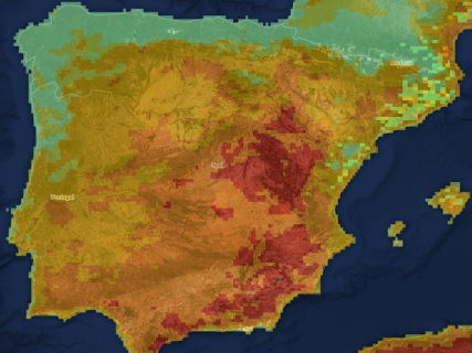
Map of fires today, August 5: Burgohondo concentrates the greatest concern after the improvement in Fermoselle and Madrid

The fire in Ávila maintains a large operation due to the risk of reproductions, while Zamora consolidates the stabilization of the fire in the Arribes and the Community of Madrid considers the fire in the Sierra Oeste under control.

5 minutes

mapa incendios 5 agosto

mapa incendios 5 agosto

Add DEMÓCRATA to Google

Ask FREN

Published

Last updated

5 minutes

Most read

The situation of the large wildfires in Spain continues to improve this Wednesday, although the firefighting services maintain a significant deployment in several points of the country. The main focus of concern remains the fire in Burgohondo (Ávila), where efforts continue to consolidate the perimeter and prevent reactivations favored by the high temperatures.

On the other hand, the fire in Fermoselle (Zamora) is evolving favorably after several days of intense work, while the Community of Madrid has already declared the large fire in the Sierra Oeste under control. In Castellón, the operation continues to monitor the perimeter of the fire in the Sierra de Espadán while the investigation into the origin of the fire continues.

Official map of active fires from Copernicus

The European Forest Fire Information System, EFFIS offers the most comprehensive public viewer to locate fires and burned areas in Spain and the rest of Europe.

Burgohondo (Ávila): efforts continue to prevent reactivations

The fire in Burgohondo continues to be the one that concentrates the greatest effort from the firefighting services. Although the evolution of the fire has improved in recent days and there have been no significant advances in the perimeter, the operation continues to work on numerous hot spots to prevent reproductions.

The tasks focus on consolidating the most sensitive areas of the fire and controlling any reactivation that may occur due to the effect of the wind or high temperatures. The extensive deployed device remains active while surveillance and finishing tasks continue.

Fermoselle (Zamora): only some hotspots remain active in inaccessible areas

The evolution of the fire declared in the Arribes del Duero continues to be favorable. The work carried out during the last few days has allowed for the consolidation of the perimeter and the reduction of fire activity to some localized hotspots in the steepest areas of the canyon.

The operation maintains surveillance over those difficult-to-access points while firefighting tasks continue. The improvement in the situation has allowed for progress towards the recovery of normality in a good part of the affected area, although some preventive measures still remain in the municipalities closest to the fire.

Sierra Oeste de Madrid: the fire is now controlled

The Community of Madrid has declared the fire in the Sierra Oeste controlled after almost two weeks of intense work by the firefighting teams.

Although the fire no longer poses a threat to the population or homes, the forces remain deployed to complete the tasks of surveillance and perimeter liquidation and to prevent any reproductions from occurring.

Sierra de Espadán (Castellón): surveillance while the investigation continues

In Castellón, the fire in the Sierra de Espadán remains stabilized and the device maintains surveillance over the perimeter to prevent possible reactivations.

At the same time, the Civil Guard continues to investigate the origin of the fire. The initial hypotheses suggest that it may have started due to a "lighter spark," although the investigation remains open and the authorities insist that it will be the result of the proceedings that determines the definitive causes of the fire.

High risk due to high temperatures

Despite the improvement recorded in most of the large fires declared during the last few weeks, the authorities maintain the alert due to the high risk of new fires due to the persistence of heat and the weather conditions expected for the coming days.

Emergency services remind the importance of taking extreme precautions in the natural environment and avoiding any activity that may provoke a fire while the extreme risk situation persists.

How to check if there is a fire nearby 

To know the specific situation of a municipality, these sources must be used:

  • EFFIS-Copernicus: satellite location, perimeters, and heat points.
  • Civil Protection: emergencies and state deployment.
  • DGT: closed or affected roads.
  • AEMET: daily fire risk level.
  • Autonomous services of 112: official status of each fire, evacuations, and confinements.

What do active, stabilized, and controlled fire mean

An active fire continues to spread and its advance has not yet been stopped. Being stabilized means that it evolves within the planned control lines, although it can still reactivate.

The consideration of controlled comes when the entire perimeter is surrounded by control lines and it is no longer expected that the fire will spread. It is only declared extinguished when there are no materials burning or possibilities of reproduction.

What to do if the fire is nearby

Authorities recommend avoiding any movement towards the affected areas and only following the indications of 112. If smoke approaches a home, doors and windows should be closed and air conditioning units that bring in outside air should be turned off.

In the event of an evacuation order, it is advisable to prepare documentation, medication, and basic items. In case of immediate danger, you should call 112 and move away in the opposite direction of the smoke and the wind.

Searcher: check the fire risk today in your municipality

Enter the name of your municipality in the searcher to know the level of forest fire risk forecasted today according to AEMET. The searcher is updated daily and shows the situation in more than 8,000 Spanish municipalities through the Forest Fire Danger Index (IPIF).

Slide the table sideways to check all the days.

The system classifies the risk into six levels:

  1. Very low
  2. Low
  3. Moderate
  4. High
  5. Very high
  6. Extreme

Each municipality appears classified according to the predominant level expected for that day.

How the fire risk map works

The search engine uses the information published daily by the State Meteorological Agency through its *Forest Fire Danger Index (IPIF).

This system combines different meteorological variables that directly influence the possibility of a forest fire starting and spreading, among them:

  • Temperature.
  • Relative humidity.
  • Wind speed and direction.
  • Accumulated precipitation.
  • State of the vegetation.

With all this data, the AEMET prepares a forecast map that allows estimating the level of danger existing at each point in the national territory.

What each risk level means

The index used by AEMET divides the fire risk into six categories:

  • Very low* and low indicate that the weather conditions are not very favorable for the start of a large fire.
  • The moderate level advises taking extra precautions, especially in activities that may generate sparks or flames.
  • When the risk becomes high, very high, or extreme, the chances of a fire starting and spreading rapidly increase considerably, especially if episodes of intense wind or very high temperatures coincide.

More key points, information and questions with FREN

AI-GENERATED CONTENT

What procedures and processes do autonomous communities follow to officially declare a fire as extinguished?

In Spain, the official declaration that a forest fire is "controlled" or "extinguished" falls under the jurisdiction of the autonomous communities and is based on fairly homogeneous technical criteria, although with their own internal procedures (INFOCA, INFOCAT, INFOREST plans, etc.). Generally, the decision is made by the commanders of the extinction device and is formalized through internal reports or minutes, which are then forwarded to the autonomous Civil Protection bodies and, when appropriate, to the State. The common framework and main variations are summarized below.

1. Usual phases of a forest fire

Although terminology may vary slightly, almost all communities use a similar sequence of operational states:

  • Active fire: the fire spreads without being controlled over its entire perimeter.
  • Stabilized: the fire's advance is stopped over most of the perimeter, but there are still fronts with potential for significant reactivation.
  • Controlled: the fire perimeter is closed by control lines (firebreaks, water lines, burned strips) and, except in exceptional circumstances, no further advance is expected.
  • Extinguished: no embers or hot spots remain that could reactivate, even under reasonably foreseeable wind or temperature increases.

2. Who decides: competent bodies and commanders

The responsibility lies with the autonomous forest fire extinction services, in coordination with the autonomous Civil Protection:

  • Technical director of extinction (or equivalent figure): usually the operational manager who proposes the change of fire status (active → stabilized → controlled → extinguished).
  • Coordination center (CECOP, CECOPI, Regional/Autonomous Operational Center): validates and records the status change and updates information to Civil Protection and, when appropriate, to the competent Ministry.
  • Autonomous Civil Protection bodies: when the fire has triggered a special emergency plan (INFOCA, INFOCAT, INFOREST, etc.), the deactivation or phase change of the plan aligns with the moment the fire is declared controlled or extinguished.

3. Technical criteria to declare "controlled"

To consider a fire controlled, extinction commanders usually require:

  • Closed perimeter by secure lines (firebreaks, defense lines with machinery, widened burn strips or indirect attack, etc.).
  • Absence of significant active fronts. Residual flames may remain inside, but without the capacity to generate new fronts.
  • Foreseeable meteorological conditions compatible with maintaining control: wind, temperature, humidity, and short-term forecast are evaluated.
  • Sufficient surveillance and finishing resources deployed to consolidate lines and address possible reignitions.

The declaration of "controlled" is usually accompanied by a progressive reduction of resources, especially aerial and more distant ones, maintaining ground brigades for finishing and surveillance.

4. Technical criteria to declare "extinguished"

To consider a fire extinguished, autonomous procedures usually require:

  • Cold perimeter: verification through brigade patrols and, in large fires, often with thermal cameras or drones, that no hot spots or active embers remain.
  • Sufficient observation time: in large fires, several days are waited after control, with surveillance patrols, to ensure no reignitions occur.
  • Review of critical zones: roots, stumps, wood accumulations, slopes, and hard-to-access areas, which are usually sources of smoldering.
  • Report from the intervention chief: formal proposal to the coordination center for the status change to "extinguished".

Only when these criteria are met does the fire officially become "extinguished" in autonomous records and, if applicable, in state and European information systems.

5. Procedures and documentation

In practice, the transition to "controlled" and "extinguished" generates several internal documents:

  • Status reports: hourly or daily reports in which the operational manager indicates the fire status and phase changes.
  • Extinction report or minutes: a more detailed document, with perimeter, affected area, resources used, damages, and incident chronology.
  • Communication to Civil Protection: when a special or territorial plan is activated, the declaration of extinguished fire supports the deactivation of the emergency.
  • Data submission to state or European bodies: for official statistics, community funds, or annual campaign reports.

6. Differences between autonomous communities

Although the basic framework is similar, there are nuances:

  • Some communities (for example, those using INFOCA, INFOCAT, INFOREST, PLATECAM plans, etc.) explicitly define in their regulations the concepts of "controlled" and "extinguished" and link the activation and deactivation of emergency phases to them.
  • In others, operational details are more in internal protocols of forest or fire services than in the regulation itself.
  • In territories with high recurrence of large fires, prolonged surveillance periods before declaring a fire extinguished are common to minimize the risk of reactivations.

In any case, the key is that the decision is always technical, made by extinction commanders, and formalized through reports and documents that serve as the basis for Civil Protection decisions and official information to the public.

What specific differences exist between the extinction protocol of Catalonia (INFOCAT) and that of Andalusia (INFOCA)? How does an autonomous community coordinate with the State and the UME in a large fire before and after declaring it extinguished? What role do municipalities and provincial councils play in the management and official closure of a forest fire?

What are the competencies of AEMET and the autonomous 112 services in managing emergencies caused by forest fires?

In Spain, the management of emergencies caused by forest fires is based on a functional division: AEMET provides specialized meteorological information and support within the National Civil Protection System, while the autonomous 112 centers are the entry point for emergencies and the basic node for operational coordination of resources. This division is mainly supported by Law 17/2015 of the National Civil Protection System, Royal Decree 186/2008 (AEMET Statute), the Basic Directive on Forest Fires, the State Plan for Forest Fires, and Royal Decree 903/1997 on the 112 number. Based on this framework, well-differentiated but interdependent functions are defined.

Competencies of AEMET in forest fires

Legal framework and role in civil protection

Royal Decree 186/2008 approves the Statute of the State Meteorological Agency and establishes it as the State meteorological service, responsible for observation, forecasting, and climatology, with specific functions supporting the safety of people and property, including civil protection and national defense. Law 17/2015 integrates these specialized services into the National Civil Protection System, reinforcing the obligation to coordinate with autonomous communities and local entities.

Prediction and assessment of meteorological danger

The Basic Directive on forest fires, approved by Royal Decree 893/2013, and developed by the State Plan for Forest Fires published by Resolution of October 31, 2014 (State Plan), assign very specific functions to AEMET:

  • Develop a Meteorological Information System for estimating forest fire danger, with meteorological danger indices and other complementary information.
  • Generate maps of meteorological forest fire danger for the entire national territory as a tool for risk forecasting.
  • Prepare daily forecasts, with at least 24-hour scope, of necessary variables (temperature, relative humidity, wind, precipitation) for calculating a meteorological forest fire danger index, and make it available to involved organizations in numerical and cartographic formats.
Support for decision-making and coordination

The State Plan specifies that AEMET's meteorological information system must allow:

  • Assessment of high-risk situations, without prejudice to specific developments by each autonomous community.
  • Ensure that danger assessment and basic data are transmitted with sufficient advance notice among the management bodies of autonomous plans and the State Plan.
  • Provide real-time support to extinction tasks from AEMET's National Prediction System operational units.

Additionally, the Directive and Plan assign the General State Administration the function of establishing, through AEMET, meteorological information procedures, which must be approved after consultation with the National Civil Protection Commission. In summary, AEMET does not coordinate extinction resources but is the official and common provider of meteorological information that conditions planning, resource activation, and operational safety.

Competencies of autonomous 112 services in forest fires

General basis of 112

Royal Decree 903/1997 regulates the emergency call service through the European number 112. It establishes that:

  • 112 is the unique European emergency telephone number with exclusive national character.
  • Network operators must route calls free of charge to the competent 112 center.
  • It is compatible with other specific numbers but is configured as unified access to emergency services.

The internal organization of 112 centers and their link to civil protection is developed in each autonomous community's regulations, based on the autonomous competencies in civil protection recognized in Law 17/2015, which highlights the creation of civil protection services and autonomous and municipal emergency coordination bodies.

Typical functions of 112 centers in forest fires

In emergencies caused by forest fires, autonomous 112 services generally perform the following functions:

  • Reception and filtering of alerts: receive calls from the public (112) and other organizations; identify location, type of fire, associated risks, and urgency level.
  • Activation and mobilization of resources: dispatch competent means (autonomous forest firefighters, brigades, autonomous or state aerial means if applicable, security forces, health services, etc.) according to the autonomous civil protection plan for forest fires.
  • Operational coordination: act as coordination center (or integrate into it) for information exchange among extinction commanders, autonomous civil protection, health services, and security forces, especially when there are simultaneous fires or impact on population and infrastructure.
  • Relation with the National Civil Protection System: channel relevant information to autonomous civil protection bodies, which in turn liaise with the Ministry of the Interior when "national interest" may be involved or the application of the State Plan or mobilization of state resources (e.g., Military Emergency Unit) is necessary.
  • Public communication and alerts: support dissemination of warnings to the population (evacuations, confinements, access restrictions to forests, etc.) in coordination with autonomous and local civil protection.
Specific relation with AEMET

Practically, 112 centers and autonomous coordination rooms integrate in their procedures the meteorological warnings and fire danger indices provided by AEMET through mechanisms established in the Directive and State Plan. This information is used both in the pre-emergency phase (reinforcement of shifts, burning prohibitions, etc.) and during the emergency (anticipating wind changes or dry storm episodes that affect the safety of responders and the population).

How is AEMET's information practically coordinated with the 112 centers of a specific autonomous community during a high-risk fire episode? What exactly does the State Civil Protection Plan for Forest Fire Emergencies foresee when an autonomous community is overwhelmed and requests state support? What differences exist between autonomous forest fire plans and how do they affect the way 112 centers operate in each territory?

What legal requirements must a municipality meet to activate confinement or evacuation measures due to fire risk?

A municipality can order preventive confinements or evacuations due to fire risk if it acts within its civil protection and security competencies, does so within the framework of approved emergency plans, and respects the principles of necessity and proportionality. The basis lies in the National Civil Protection System Law, the Local Regime Bases Law, and basic civil protection regulations, which allow imposing personal and material obligations and suspending activities in emergencies. These measures must be based on a technical risk assessment, coordinated with the autonomous community (and, if applicable, with the State), and formalized through motivated acts, usually proclamations or mayoral resolutions. Additionally, any restriction of rights must be limited to the strictly necessary time and accompanied by guarantees of information to the population.

Municipal competence basis

Law 17/2015 of the National Civil Protection System integrates civil protection into public security (art. 149.1.29.ª CE) and foresees the participation of Local Administration in the system, including the creation of the National Civil Protection Council where autonomous communities and local entities are represented.

Meanwhile, Law 7/1985, Regulating the Bases of the Local Regime, recognizes municipalities' own competencies in:

  • Civil protection, prevention, and fire extinction (art. 25.2.f).
  • Mandatory provision of civil protection and fire prevention and extinction services in municipalities with more than 20,000 inhabitants (art. 26.1.c).

The mayor also holds the power to issue proclamations (art. 21 of Law 7/1985), which is the typical way to order confinements, zone closures, local traffic restrictions, or punctual evacuations within the municipal area.

Civil protection regulations and types of plans

Law 17/2015 configures civil protection as a public service and establishes that competent authorities, including local ones, may in emergencies:

  • Impose the duty of cooperation on individuals and legal entities.
  • Order mandatory personal services in emergencies.
  • Decree temporary requisition of goods, temporary occupation, and suspension of activities (art. 7 and following).
  • Order evacuation of people, with explicit reference to respecting the entry regime into homes provided in the Organic Law on citizen security.

Restrictive measures on rights must, according to this law, have a duration limited to the strictly necessary time and be adequate to the emergency's entity.

Royal Decree 524/2023, Basic Civil Protection Standard, develops the system of plans (state, autonomous, and territorial) and defines phases and operational situations. It distinguishes between pre-emergency and emergency phases, expressly foreseeing the adoption of "specific measures for the protection and self-protection of the population" in each phase. On this basis, municipalities integrate into the autonomous Territorial Plan and usually approve:

  • Municipal Territorial Plan or Municipal Emergency Action Plan.
  • Special plans against specific risks (such as forest fire), when required by autonomous regulations.
  • Self-protection plans for local infrastructures and facilities.

Material and procedural requirements

From a procedural point of view, Law 39/2015, on Common Administrative Procedure, requires that any act limiting rights be duly motivated (burdensome acts) and that provisional measures comply with the principles of proportionality, effectiveness, and least burden. This law allows, for example, the temporary suspension of activities or closure of establishments for safety reasons, provided they do not cause irreparable harm or violate rights protected by law.

In practice, to order confinement or evacuation due to fire risk, the municipality should at least meet these requirements:

  • Clear competence basis: frame the measure within its civil protection and security competencies established in Law 7/1985 and Law 17/2015.
  • Technical risk assessment: have reports from emergency services, forestry technicians, or civil protection certifying the fire's severity and the need to confine or evacuate.
  • Adjustment to the civil protection plan: activate the phase and operational situation foreseen in the corresponding autonomous/municipal plan for fire risk, according to the Basic Standard.
  • Competent body: express agreement of the mayor (or the emergency management body designated in the plan), usually formalized through a motivated proclamation or resolution.
  • Inter-administrative coordination: immediate communication to the autonomous emergency coordination center and, if applicable, to the Government Delegation/Subdelegation, especially if the emergency escalates to autonomous or national interest.
  • Respect for fundamental rights: limit the affected area, duration, and intensity of the restriction, inform the population of risks and conduct to follow, and respect the constitutional regime of home entry and freedom of movement.

Guarantees for the population

Law 17/2015 recognizes citizens' right to be informed of significant collective risks, planned measures, and self-protection behaviors. It also establishes the general duty to obey civil protection authorities' orders but links those orders to the aforementioned temporal and proportionality limits, as well as the right to compensation for damages derived from requisitions, occupations, or activity suspensions when applicable.

What specific role does the mayor have and what role does the autonomous community have when a forest fire emergency is declared in a municipality? How should a municipal proclamation of confinement or evacuation be drafted to comply with Law 39/2015 and Law 17/2015? What legal differences exist between a municipal confinement due to fire and one agreed upon in an autonomous or state-level emergency?

Play

Test your knowledge with FREN!

How much do you know about this topic? Answer the following 3 questions.

Which forest fire currently causes the greatest concern in Spain?

Question 1 of 3

What risk level does the IPIF indicate when conditions are unfavorable for the start of a large fire?

Question 2 of 3

Which organizations provide official information about the location and evolution of forest fires in Spain?

Question 3 of 3

Hola, soy Fren. ¿Cómo te ayudo?