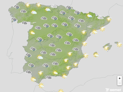

The Bruna storm will maintain this Tuesday a situation of instability in much of Spain. Rainfall weather warnings reach the red level in Castilla y León and Extremadura, orange in Castilla-La Mancha, and yellow in Galicia and the Community of Madrid. Asturias and Cantabria have yellow wind warnings.
In contrast with the west, the Balearic Islands and the Mediterranean coast will have a more stable day, with the presence of high clouds and no precipitation expected. In the Canary Islands, the showers will gain intensity toward the end of the day with the arrival of a front from the western islands.
A drop in temperatures in Galicia and the southern plateau
The maximum temperatures will rise in the north-eastern third of the mainland, fall in Galicia, the southern plateau, and the Canary Islands, and remain without major changes in the rest of the country. The minimum temperatures will also show no significant variations, although slight drops are expected in the Canary Islands and the south-eastern mainland.
In the Pyrenees, there will be weak frosts. In addition, mist and morning fog may form in the interior of the eastern third, the Ebro valley, and mountainous areas, with greater persistence in the higher areas affected by the fronts.
The wind will blow from the south component and with moderate intensity over much of the Peninsula and the Balearic Islands. AEMET forecasts strong intervals and very strong gusts on the Galician Atlantic coasts and the mountains of the northern mainland.
In the Mediterranean regions and the eastern interior, the wind from the west component will predominate, moderate on the coasts. In the Canary Islands, it will be moderate from the south-west, with probable very strong gusts on the mountainous islands toward the end of the day.
The archipelago will have cloudy intervals and showers on the islands with greater relief. The situation will worsen in the last hours as a front arrives that will cover the skies and leave strong or very strong precipitation, accompanied by thunderstorms, on the most western islands.