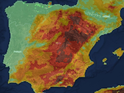

The wildfire map of this Wednesday, August 26, reflects a different situation than in recent days. The fire in Segorbe, in the Sierra Calderona, has been brought under control after six days of work, while Collserola, in Barcelona, is now the main focus after the fire declared during the afternoon of Tuesday.
The map also includes other large fires from August that remain controlled or under surveillance, such as Pinofranqueado, in Las Hurdes, and Las Peñas de Riglos, in Huesca. The teams are maintaining monitoring work on the affected perimeters before they can be declared definitively extinguished.
Official map of active fires from Copernicus
The European Forest Fire Information System, EFFIS, offers a public viewer to locate fires, heat points, and burned areas in Spain and the rest of Europe.
The map allows observing the perimeters detected by satellite, but the appearance of a heat point does not necessarily mean that there is an active wildfire. To know the official status of each emergency, the regional emergency services of 112 and firefighting must also be consulted.
Collserola concentrates the main focus of the last hours
The fire declared during the afternoon of Tuesday in the vicinity of the Collserola Natural Park has become the main focus of attention on the map. The flames affected a forested area near the Barcelona neighborhoods of Canyelles and Torre Baró and forced the preventive evacuation of several neighbors.
The emergency services also established confinements in the nearby areas while working to contain the fire. The fire was stabilized during the night, although the team remains deployed to monitor the perimeter and act on any hot spots that may persist.
Segorbe is under control after affecting 633 hectares
The wildfire in Segorbe, caused by a lightning strike on August 20, has been brought under control after affecting 633 hectares in the vicinity of the Sierra Calderona Natural Park.
The favorable evolution first allowed for its stabilization and then to advance to the control phase. The teams continue working on the affected area and the fire remains under surveillance until conditions allow for its definitive extinction to be declared.
Pinofranqueado remains controlled in Las Hurdes
The fire in Pinofranqueado, in the Cáceres region of Las Hurdes, remains controlled after several days of emergency. The fire affected about 3,765 hectares and forced the evacuation of different hamlets and the adoption of confinement measures during the most complicated moments.
The current situation allows for the work to focus on surveillance and the recovery of the affected areas. The perimeter continues to be monitored to avoid possible re-ignitions as the phase after the emergency progresses.
Las Peñas de Riglos maintains surveillance work
The fire in Las Peñas de Riglos, in Huesca, remains controlled after being one of the largest fires recorded during August. The INFOAR operation continues work on the perimeter to eliminate hot spots and advance towards extinction.
The favorable evolution allowed for the lifting of evacuations and the gradual reduction of the deployment during the emergency. Current work focuses on preventing re-ignitions in the affected areas and definitively consolidating the perimeter.
Biscarrués and Aliaga continue with favorable evolution
The fires declared during the past weekend in Biscarrués, in Huesca, and Aliaga, in Teruel, maintain a favorable evolution. The first was stabilized shortly after being declared, and the second was reported as controlled.
The Aragonese operation continues to monitor both fires and carries out the necessary work to complete their extinction. Their rapid evolution prevented them from reaching the scale of the large fires that have marked the month of August.
To know the specific situation of a municipality, these sources should be used:
- EFFIS-Copernicus: satellite location, perimeters, and hot spots.
- Civil Protection: emergencies and state deployment.
- DGT: closed or affected roads.
- AEMET: daily fire risk level.
- Autonomous services of 112: official status of each fire, evacuations, and confinements.
Finder: check the fire risk today in your municipality
Enter the name of your municipality in the search engine to know the level of forest fire risk forecasted today according to AEMET. The search engine is updated daily and shows the situation in more than 8,000 Spanish municipalities through the Forest Fire Danger Index (IPIF).
↔ Slide the table sideways to check all days.
The system classifies the risk into six levels:
- Very low.
- Low.
- Moderate.
- High.
- Very high.
- Extreme.
Each municipality appears classified according to the predominant level expected for that day.
How the fire risk map works
The search engine uses the information published daily by the State Meteorological Agency through its *Forest Fire Danger Index (IPIF).
This system combines different meteorological variables that directly influence the possibility of a forest fire starting and spreading, among them:
- Temperature.
- Relative humidity.
- Wind speed and direction.
- Accumulated precipitation.
- State of the vegetation.
With all this data, AEMET prepares a forecast map that allows estimating the level of danger existing at each point of the national territory.
What each risk level means
The index used by AEMET divides the fire risk into six categories:
- Very low* and low indicate that the weather conditions are not favorable for the start of a large fire.
- The moderate level advises taking extreme caution, especially in activities that may generate sparks or flames.
- When the risk becomes high, very high, or extreme, the chances of a fire starting and spreading rapidly increase considerably, especially if episodes of intense wind or very high temperatures coincide.