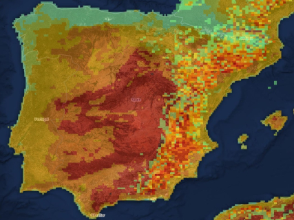

Spain faces this Tuesday August 11 a new day of vigilance over several wildfires. The focus of Fog, in Huelva, continues among those that concentrate the most concern, while other fires keep emergency services deployed in different parts of the country.
The situation changes rapidly depending on the evolution of the wind, temperatures, and firefighting efforts, so the fire map allows locating the main points where activity continues and tracking the evolution of the fires.
Official map of active fires from Copernicus
The European Forest Fire Information System, EFFIS offers the most comprehensive public viewer to locate fires and burned areas in Spain and the rest of Europe.
Andalusia: Fog remains the main focus
The fire in Fog, in Huelva, remains active after several days of firefighting efforts. The fire has forced preventive evacuations and maintains a large deployment on the ground due to the difficulty in containing its advance.
Weather conditions continue to be one of the main factors that affect the evolution of the fire, with high temperatures and wind that can favor changes in the behavior of the flames.
Castellón: the fire in Tírig evolves better
In the Valencian Community, the fire in Tírig, in Castellón, has improved after several days of firefighting efforts. The fire forced preventive measures to protect the population of nearby towns, although its evolution has allowed progressively reducing the pressure on the deployment.
The situation of this fire contrasts with that of other hotspots that remain active and whose evolution continues to depend on the weather conditions of the coming hours.
The fire map allows tracking hotspots
In addition to monitoring large fires, fire activity maps incorporate information from satellites to locate hotspots. NASA's FIRMS system uses data from the VIIRS sensor to identify thermal activity and update the location of these points. RTVE combines this data with information from the European Forest Fire Information System (EFFIS), integrated into Copernicus, to provide a view of the evolution of the fires and the affected area.
These heat points do not necessarily equate to active wildfires: they can also correspond to other heat sources detected by satellites. Therefore, to know the specific situation of each fire, the information must be contrasted with emergency services and the responsible administrations.
A day marked by the risk of fires
The situation of the fires also coincides with a day of high temperatures and a high forest risk level in different areas of the country. The meteorological evolution will be decisive to know which fires can consolidate their control and which may experience new complications.
The map, therefore, should be interpreted as a monitoring tool and not as a closed list of all existing fires in Spain. The hotspots can appear, disappear, or change in intensity within hours.
To know the specific situation of a municipality, these sources should be used:
- EFFIS-Copernicus: satellite location, perimeters, and heat points.
- Civil Protection: emergencies and state deployment.
- DGT: closed or affected roads.
- AEMET: daily level of fire risk.
- Autonomous services of 112: official status of each fire, evacuations, and confinements.
Searcher: check the fire risk today in your municipality
Enter the name of your municipality in the searcher to know the level of wildfire risk forecasted today according to AEMET. The searcher is updated daily and shows the situation in more than 8,000 Spanish municipalities through the Forest Fire Danger Index (IPIF).
The system classifies the risk into six levels:
- Very low
- Low
- Moderate
- High
- Very high
- Extreme
Each municipality appears classified according to the predominant level expected for that day.
How the fire risk map works
The search engine uses the information published daily by the State Meteorological Agency through its *Forest Fire Danger Index (IPIF).
This system combines different meteorological variables that directly influence the possibility of a forest fire starting and spreading, among them:
- Temperature.
- Relative humidity.
- Wind speed and direction.
- Accumulated precipitation.
- State of the vegetation.
With all this data, AEMET prepares a forecast map that allows estimating the level of danger existing at each point of the national territory.
What each risk level means
The index used by AEMET divides the fire risk into six categories:
- Very low* and low indicate that the weather conditions are not very favorable for the start of a large fire.
- The moderate level advises taking extra precautions, especially in activities that may generate sparks or flames.
- When the risk becomes high, very high, or extreme, the chances of a fire starting and spreading rapidly increase considerably, especially if episodes of intense wind or very high temperatures coincide.