

The rainstorm affecting the east of Spain raises this Thursday its level of danger in the Comunitat Valenciana. AEMET maintains the orange alert from 14:00 hours and raises it to red from 18:00 hours on the coast of Valencia and in the northern coast and interior of Castellón, with a forecast of precipitation of up to 90 liters per square meter in one hour and accumulations that can reach 250 liters in 12 hours.
Civil Protection has also activated the system ES-Alert to warn the population of Valencia and Castellón about the arrival of the highest risk period. The message recommends avoiding travel, staying away from waterways and ravines, and moving to upper floors if the water level rises.
These are the areas that will be on red alert
The maximum level affects five meteorological zones of the Comunitat Valenciana: the northern and southern coast of Valencia, and the northern coast, southern coast, and northern interior of Castellón. In total, there are 234 municipalities included in the areas under red alert, according to the breakdown published based on AEMET's warnings.
In the province of Valencia, the red alert reaches, among other municipalities, València, Sagunto, Torrent, Paterna, Mislata, Catarroja, Albal, Alfafar, Aldaia, Alboraya, Burjassot, Chiva, Llíria, Manises, Massanassa, Paiporta, Picanya, Picassent, Silla, Riba-roja de Túria, Rafelbunyol, Puçol, El Puig, and La Pobla de Vallbona.
In Castellón, the red level affects the northern coast and interior of the province. The episode may leave especially intense and persistent precipitation, with accumulations of up to 250 liters per square meter in 12 hours in the most exposed areas.
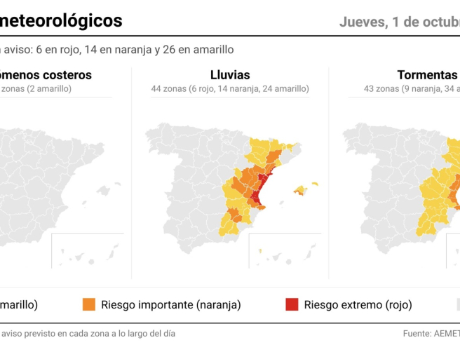
The red alert will initially be active from 18:00 hours this Thursday until the early hours of Friday, although AEMET may modify the areas and times depending on the evolution of the meteorological situation.
Which municipalities are on orange alert
The orange level extends to other areas of the Comunitat Valenciana and nearby territories. In Valencia, before the entry into force of the red level, the orange alert affects from 14:00 hours areas that may register very heavy precipitation, storms, hail, and gusts of wind.
Among them are la Costera, la Canal de Navarrés, and la Vall d'Albaida, where accumulations of up to 50 liters per square meter in one hour and 120 liters in 12 hours can be reached.
In the province of Alicante, the episode also leaves areas on orange alert for rain. The expected intensity is lower than that of the areas under red level, but the risk of heavy rainfall and storms also requires taking extra precautions.
The orange alert also extends to other areas of the eastern peninsula, especially Aragón, Castilla-La Mancha, Cataluña and Balearic Islands, within the episode of intense rain affecting the Mediterranean. In Cataluña, moreover, the southern coast of Tarragona is among the areas with red alert, with forecasts of torrential rainfall.
Valencia goes from orange to red in four hours
The expected evolution for this Thursday makes the time frame especially important. Between 14:00 and 18:00 hours the orange level will be active, while from 18:00 hours the red alert will come into effect in the affected areas of Valencia and Castellón.
In the city of València, the City Council has advanced the closure of educational centers to 15:00 hours and has suspended various activities and services as a preventive measure. The suspension will last through Friday due to the forecast that the heaviest rains will occur during the night and early morning.
The episode may be accompanied by heavy storms, hail, and very intense gusts of wind, in addition to locally persistent torrential rain. The combination of intense precipitation and high accumulations increases the risk of flooding and flash floods.
In light of the red alert, authorities recommend avoiding travel, especially from the hours when precipitation intensifies. It is also advised to stay away from ravines, riverbeds, and flood-prone areas and to respect any traffic closures that may be established.