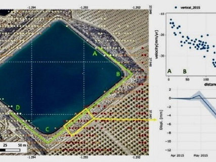

The regional Government has launched an innovative project to increase the safety of irrigation ponds through satellite radar technology. This system will allow for the early detection of possible movements and millimetric deformations both in the ground and in the infrastructures themselves.
According to the regional Executive, the action is based on radar interferometry techniques (InSAR) and on the exploitation of data from the European Sentinel-1 satellites of the Copernicus program. This information will be used as a complement to the usual inspection and monitoring methods, in order to move towards a more preventive surveillance model, supported by continuous data analysis.
The InSAR technology makes it possible to compare radar images taken by satellite at different moments, identifying millimetric variations in the surface of the ground and in the structures. Thanks to this capability, there will be an additional tool to recognize early signs of deformation and thus facilitate the scheduling of conservation and maintenance work.
"The goal is to move towards a system that allows for the identification of possible patterns of behavior and early warning signs in advance, improving the capacity for monitoring, maintenance, and prevention," they explained.
First phase in 15 ponds in Águilas and Totana
In the first stage, the work will focus primarily on a representative group of 15 ponds located in the municipalities of Águilas and Totana. In these infrastructures, the new methodology will be applied to verify its effectiveness in monitoring and detecting possible displacements.
At the same time, a specific study of special technical relevance will be carried out in the Sangonera pond. This analysis will allow for the evaluation and modeling of to what extent the data from the satellite can identify early signs linked to potential structural instability processes.
The Minister of Water, Agriculture, Livestock, and Fisheries, Joaquín Buendía, has emphasized that "with this project we put the eyes of space at the service of the safety of our hydraulic infrastructures and, most importantly, the protection of people."
Likewise, he has emphasized that "technology allows us to detect millimetric movements that may be invisible to the human eye and to have information that helps us anticipate possible anomalies before they become an incident," Buendía has pointed out.
The regional official has also stressed that "it is not about replacing traditional engineering, but about enhancing it with new technological tools that allow us to have a broader, more precise, and continuous view of the state of our reservoirs."
Finally, he has reminded that "in the Region of Murcia we are a world reference in the management and efficient use of water and we want to be so in the safety of the infrastructures that make its storage possible. Innovation and digitalization are already tools that we use to move towards a more modern, predictive, and data-driven Administration," he has added.