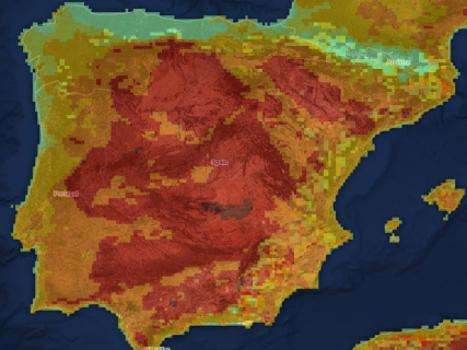

The situation of the wildfires remains especially complicated this Thursday in several points of Spain. The large hotspots of Niebla, in Huelva, and Las Peñas de Riglos, in Huesca, concentrate a good part of the extinction resources and attention due to the affected area and its evolution.
The map allows locating the main fires that remain active and checking how the most relevant hotspots are distributed across the national territory.
Official map of active fires from Copernicus
The European Forest Fire Information System, EFFIS offers the most complete public viewer to locate fires and burned areas in Spain and the rest of Europe.
Niebla continues as the main focus of concern
The wildfire in the Raboconejo area, in the municipality of Niebla, remains the most concerning fire among those that remain active in Spain.
The flames have already affected more than 31,000 hectares between Huelva and Sevilla and maintain several fronts with activity. The emergency has forced new preventive evacuations and raises the number of displaced persons to more than 700 since the start of the fire.
The latest report from the Junta de Andalucía keeps the fire "very active," especially in the northern, eastern, southeastern, and northeastern areas. The extinction teams are trying to take advantage of the lower wind intensity to consolidate the flanks and contain the advance of the flames.
Operational situation 2 of the INFOCA Plan remains activated due to the risk to populations, infrastructures, and communication routes. The efforts involve regional, state, and Military Emergency Unit resources.
Las Peñas de Riglos remains active at level 2
The other major focus of concern is located in Las Peñas de Riglos, in Huesca, where the fire remains active and is at operational situation 2, level 2, of the Special Civil Protection Plan for Emergencies due to Wildfires in Aragón.
The affected area is around 5,700 hectares, and the fire has forced the preventive evacuation of nine localities and a campsite located nearby. Villalangua, Salinas de Jaca, Ena, Centenero, Arbués, Alastuey, Bailo, Larués, and Botaya are among the evacuated localities.
During the night, hundreds of personnel have worked on consolidating the defense lines to prevent further advances. The fire has also caused traffic restrictions and closures of the N-240 in some sections.
The Civil Guard has arrested a 28-year-old man for his alleged connection to the origin of the fire. Investigators located materials from some works carried out on the A-132 at the starting point, although the investigations remain open.
Peñamellera Alta remains under surveillance
In Peñamellera Alta, Asturias, satellite observation systems have detected a significant concentration of heat spots. The evolution during the night would have been favorable, although the area remains under surveillance for possible reproductions.
Satellite data must be interpreted with caution, as they indicate thermal anomalies compatible with a fire, but do not replace the classification of the regional emergency services. Therefore, Peñamellera Alta is among the points with detected activity, although with a dimension and danger much lower than those of Niebla and Las Peñas de Riglos.
Castellví de la Marca remains stabilized
In Castellví de la Marca, Barcelona, the Bombers de la Generalitat maintain a deployed operation following the forest fire declared in the Castellot area.
The fire has affected about eight hectares and forced the confinement of four urbanizations for several hours, where around 170 people live. The measure was lifted after the evolution of the fire improved.
The firefighters have declared the fire stabilized, so it no longer advances freely within its perimeter. It is still not considered controlled or extinguished and continues to be included in the balance of open fires.
The national balance includes 34 open fires
The national monitor that collects information from the regional services counted at the beginning of this Thursday 34 open forest fires. The figure includes active, stabilized, and controlled fires that have not yet received the definitive declaration of extinction.
The majority are concentrated in Castilla y León, with 15 fires, all controlled or stabilized; the Comunitat Valenciana, with eight open forest incidents; and Catalonia, with five fires among active, stabilized, and controlled. Castilla-La Mancha adds two forest emergencies, while Andalucía, Aragón, and Asturias concentrate the main hotspots with detected activity.
Among the fires that remain in the records despite being controlled or stabilized are those of Segovia, Navas de San Antonio, Burgohondo, Fermoselle, Tírig, La Vall d’Uixó, Sant Bartomeu del Grau, Naut Aran, Gaià, and Vilaller.
The figure does not come from a single national counter updated simultaneously. The autonomous communities manage and classify their fires on their own schedules, while satellite data can detect thermal hotspots that have not yet been incorporated into the official balances.
Spain surpasses 226,000 hectares burned in 2026
The wildfires have burned 226,391 hectares in Spain since the beginning of 2026, according to the latest provisional data from the Ministry for Ecological Transition and the Demographic Challenge.
The affected area far exceeds that recorded during the same period in 2025. Spain also accumulates 43 large wildfires, those that exceed 500 hectares, compared to the 24 counted at this time last year.
The high temperatures, low humidity, and accumulated dryness keep the fire danger at very high or extreme levels in much of the country. Civil Protection calls for extreme precautions and to avoid any activity that may generate sparks or fire in forest areas.
To know the specific situation of a municipality, these sources should be used:
- EFFIS-Copernicus: satellite location, perimeters, and hotspots.
- Civil Protection: emergencies and state deployment.
- DGT: closed or affected roads.
- AEMET: daily fire risk level.
- Autonomous 112 services: official status of each fire, evacuations, and confinements.
Searcher: check the fire risk today in your municipality
Enter the name of your municipality in the searcher to know the level of wildfire risk forecasted today according to AEMET. The searcher is updated daily and shows the situation in more than 8,000 Spanish municipalities through the Forest Fire Danger Index (IPIF).
The system classifies the risk into six levels:
- Very low
- Low
- Moderate
- High
- Very high
- Extreme
Each municipality appears classified according to the predominant level expected for that day.
How the fire risk map works
The search engine uses the information published daily by the State Meteorological Agency through its *Forest Fire Danger Index (IPIF).
This system combines different meteorological variables that directly influence the possibility of a forest fire starting and spreading, among them:
- Temperature.
- Relative humidity.
- Wind speed and direction.
- Accumulated precipitation.
- State of vegetation.
With all this data, AEMET prepares a forecast map that allows estimating the level of danger existing at each point of the national territory.
What each risk level means
The index used by AEMET divides the fire risk into six categories:
- Very low* and low indicate that the weather conditions are not very favorable for the start of a large fire.
- The moderate level advises taking extreme caution, especially in activities that may generate sparks or flames.
- When the risk becomes high, very high, or extreme, the chances of a fire starting and spreading rapidly increase considerably, especially if episodes of intense wind or very high temperatures coincide.