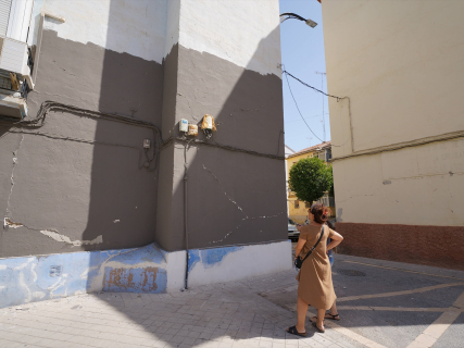
Granada registers a new earthquake of magnitude 2.1 in Dílar a day after the tremor of 3.1

The IGN locates the movement this Sunday afternoon and records three other small tremors in the vicinity of Dílar and La Zubia during the day.

1 minute

EuropaPress 7719649 imagenes destrozos causado terremoto 18 agosto 2026 granada andalucia

EuropaPress 7719649 imagenes destrozos causado terremoto 18 agosto 2026 granada andalucia

Add DEMÓCRATA to Google

Ask FREN

Published

Last updated

1 minute

Most read

A 2.1 magnitude earthquake has been recorded this Sunday, October 4, northwest of Dílar, in Granada. The National Geographic Institute (IGN) places the movement at 19:45, peninsular time, and at a depth of one kilometer.

The tremors recorded this Sunday in Granada

The consulted list from the IGN includes these four movements:

Earthquakes in Granada: IGN records from October 4, 2026
Peninsular time Location Magnitude Depth
08:22 Southeast of La Zubia 1.6 6 km
13:03 West of La Zubia 1.7 5 km
19:11 North of Dílar 1.6 7 km
19:45 Northwest of Dílar 2.1 1 km

Source: National Geographic Institute. Records available in the query made on October 4, 2026, after the movement at 19:45. The list includes earthquakes of magnitude equal to or greater than 1.5 or felt by the population; it is not a comprehensive count of all microtremors. Data subject to revision.

One day after the 3.1 magnitude earthquake

The most immediate precedent is the earthquake on Saturday, October 3, recorded at 19:05 and of magnitude 3.1. The updated sheet from the IGN places its epicenter northwest of Vegas del Genil and attributes a maximum intensity of III.

The first reports located it in the vicinity of Cúllar Vega. The updated reference should be taken into account when comparing both episodes.

The movement this Sunday in Dílar has a lower magnitude than that of Saturday. The succession of records, by itself, is not enough to present what happened as a worsening of the situation nor to attribute all the tremors the condition of aftershocks.

Data subject to revision

The IGN warns that the information may change as seismic analysis progresses. The location, depth, or magnitude initially disseminated should be read with that caution.

More key points, information and questions with FREN

AI-GENERATED CONTENT

What procedures does the National Geographic Institute follow to review and update seismic activity data in Spain?

The National Geographic Institute (IGN) manages seismic activity in Spain through a continuous flow of detection, review, and data updating. According to our database, which collects official records and coverage from the newspaper Demócrata, the process combines automatic systems of the National Seismic Network with a manual technical review that refines the parameters until they are incorporated into the seismic catalog in a more stable form.

1. Automatic detection by the National Seismic Network

Monitoring relies on a very dense National Seismic Network, with dozens of permanent stations and, when necessary, additional portable stations in active zones. These sensors continuously record seismic waves and allow:

  • Rapid detection of an earthquake occurrence.
  • Calculation of an initial value of time, epicentral location, depth, and magnitude.
  • Real-time transmission of records to IGN analysis centers.

The National Plan for Seismic, Volcanological, and Other Geophysical Phenomena Surveillance, approved by the Government for the 2025‑2028 period, strengthens this network and also foresees tools based on artificial intelligence to improve the speed and quality of these initial solutions.

2. Preliminary publication in near real-time

With that first automatic solution, the IGN quickly disseminates a preliminary event sheet. This information is published in:

  • The latest earthquakes viewer and the IGN seismic activity map.
  • Lists of recent earthquakes that can be consulted by date, area, magnitude, or depth.
  • Applications such as “IGN Earthquakes,” which show almost live the recorded events.

At this stage, the data are considered provisional. The IGN itself warns that magnitude, depth, coordinates, or even the locality chosen to describe the epicenter may be modified as the analysis progresses.

3. Technical review and parameter validation

After the preliminary publication, a continuous technical review begins:

  • More records from National Seismic Network stations and other collaborating networks are incorporated.
  • Location, depth, and magnitude are recalculated as more information becomes available.
  • Initial discrepancies common in the first hours after an earthquake are corrected.

Demócrata's coverage of sequences like Granada shows this process in practice: earthquakes initially reported with a magnitude, depth, or intensity are reviewed several times until converging on more precise values. The IGN makes clear that this possibility of revision is a normal part of the procedure.

4. Permanent update of the seismic catalog

The reviewed data are integrated into the official earthquake catalog, which the IGN maintains under permanent review. It is not a closed list by file, but a record that:

  • Is updated in real time when new events are detected.
  • Is corrected when parameters change after instrumental review.
  • Allows searches by dates, geographic area, magnitude, intensity, and depth.

In addition to this online catalog, the IGN prepares daily summaries of general seismic activity in Spain and adjacent areas, which serve as a basis for periodic reports, technical publications, and hazard studies.

5. Macroseismic information and citizen participation

The review procedure is not based solely on instruments. The IGN also collects macroseismic information through questionnaires in which the population indicates how they felt the earthquake (perceived movement, people's reactions, displaced objects, possible damages). These data:

  • Help estimate the intensity in each locality, distinct from magnitude.
  • Are incorporated into effect maps and complement the purely instrumental analysis.

6. Coordination with Civil Protection and other agencies

The IGN is the State body responsible for detection, location, and calculation of seismic parameters, but emergency management corresponds to Civil Protection and competent administrations. Therefore:

  • Results from the National Seismic Network are shared with the National Civil Protection System and emergency services.
  • The National Surveillance Plan promotes coordination with other scientific networks and administrations to improve early warnings and response.

Overall, the IGN procedure can be summarized as a continuous cycle of automatic detection → provisional publication → technical review and validation → catalog update → dissemination to authorities and citizens, with a seismic catalog that is corrected and enriched permanently as better data become available.

How does the National Geographic Institute coordinate with Civil Protection and autonomous communities when a major seismic crisis occurs? What specific improvements does the National Plan for Seismic, Volcanological, and Other Geophysical Phenomena Surveillance introduce in the National Seismic Network? How can I interpret the data (magnitude, depth, intensity) that appear in the IGN latest earthquakes viewer?

What are the competencies of the Government Delegation in Andalusia regarding seismic emergency management?

The Government Delegation in the Autonomous Community of Andalusia is the body that represents the General State Administration (AGE) in Andalusian territory and, in matters of civil protection and seismic risk, acts within the National Civil Protection System defined by Law 17/2015 and the State Civil Protection Plan against Seismic Risk. Its competencies are always articulated in coordination with the Junta de Andalucía — which has ordinary direction of emergencies in its territory — and with local entities.

1. General framework of civil protection competencies

According to Law 17/2015, of the National Civil Protection System, the Ministry of the Interior is the state authority responsible for civil protection and the Government Delegates, “under the instructions of the Ministry of the Interior, coordinate civil protection actions of the AGE bodies and services in their territorial scope, in cooperation with autonomous communities and local entities.” This translates into that, also in seismic emergencies:

  • The Government Delegation channels the action of state bodies and services (Civil Guard, National Police, UME, other AGE means) deployed in Andalusia.
  • Acts as a political-administrative liaison point between the central Government and the Junta de Andalucía in civil protection matters.
  • Participates in cooperation mechanisms of the National Civil Protection System and in the application of state and autonomous plans.
  • Exercises sanctioning powers in minor civil protection infractions typified in Law 17/2015.

Additionally, the state civil protection structure (Directorate General / General Secretariat of Civil Protection and Emergencies) coordinates its relations with the civil protection units of the Government Delegations and Subdelegations, which provide technical-operational support in each territory.

2. Specific role in seismic emergencies

The State Civil Protection Plan against Seismic Risk and the Basic Guideline for seismic risk planning foresee a multi-level organization in which autonomous communities (in this case, the Junta de Andalucía) direct the emergency while it is of autonomous scope, and the State assumes a reinforced role when there is national interest.

In that scheme, the functions of the Government Delegation in Andalusia are fundamentally:

  • Ordinary phase (without national interest):
    • Participate in the Integrated Operational Coordination Center (CECOPI) established in Andalusia when the Junta requires state support or mobilization of resources outside the initially affected territory.
    • Serve as a channel between the Directorate General of Civil Protection and Emergencies and Andalusian civil protection bodies for the distribution of seismic information sent by the National Geographic Institute (IGN) and for the offer or request of state means.
    • Facilitate the operational integration of state means into autonomous and local plans (State Security Forces and Corps, UME, other AGE resources) when the Junta activates the Andalusian Emergency Plan against Seismic Risk.
  • Emergency of national interest (declared by Interior):
    • According to the State Seismic Risk Plan, in each directly affected community a Steering Committee of the autonomous plan is constituted, integrated by the body designated by the community and a representative of the Ministry of the Interior.
    • In that scenario, the direction function of the community's plan passes to the Government Delegate, who:
      • Directs the Autonomous Community Plan “following the guidelines of the Minister of the Interior” and in coordination with the Operational Direction of the State Plan.
      • Mobilizes resources located in Andalusia that are necessary at the request of the state Operational Direction.
      • Ensures coordination between the State seismic Plan and autonomous and local plans (territorial and special).
      • Keeps the Steering Council of the State Plan informed through the Directorate General of Civil Protection and Emergencies.
      • Organizes, together with the Junta, information to the population about the evolution of the emergency and self-protection measures.
3. Coordination with the Junta de Andalucía and Andalusian plans

In Andalusia there is specific legislation (Law 2/2002, on Emergency Management, and the Andalusian Territorial Emergency Plan –PTEAnd–, along with the autonomous special plan against seismic risk) that assigns the Junta the general direction and coordination of emergencies in Andalusian territory. Within that framework:

  • The autonomous direction of an “ordinary” seismic emergency corresponds to the Junta, which activates and manages its seismic plan, convenes the advisory committee, and establishes coordination centers.
  • The Government Delegation in Andalusia does not replace the Junta in that direction, but:
    • Sits on coordination bodies (CECOP / CECOPI) as a representative of the AGE.
    • Coordinates the entry and use of state means in the Andalusian operational structure.
    • Serves as a permanent channel of political and technical communication with the central Government throughout the emergency.

In summary, in a seismic emergency in Andalusia the Government Delegation acts as a hinge between the Andalusian civil protection system and the National Civil Protection System: it coordinates state resources in the territory, participates in the autonomous command structure, and if the Ministry of the Interior declares the emergency of national interest, assumes direction of the autonomous plan within Andalusia under the guidelines of the Government of Spain.

Could you explain in more detail how a national interest emergency is declared and what exactly changes for the Government Delegation in Andalusia? What specific role do CECOP and CECOPI have in Andalusia and how is the Government Delegation integrated into them during a seismic crisis? Can you compare the competencies of the Government Delegation in Andalusia with those of the Junta in a practical case of an earthquake in Granada?

What requirements must an earthquake meet to be officially classified as an aftershock according to Spanish regulations?

In Spanish regulations, there is no legal-technical definition with numerical thresholds (magnitude, hours, distance) that specify when an earthquake "becomes" an aftershock. What does exist is a general definition in the Basic Guideline for Civil Protection Planning against Seismic Risk and the practical referral to the scientific criteria of the National Geographic Institute (IGN), which is the body that classifies events in operational practice.

Regulatory definition of "aftershock"

The Basic Guideline for Civil Protection Planning against Seismic Risk, approved by Agreement of the Council of Ministers on April 7, 1995 (published by Resolution of May 5, 1995), includes a glossary where it expressly defines:

  • Aftershocks: "Earthquakes that follow the main earthquake of an area and are genetically linked to it."

This is, to date, the clearest and directly "official" formulation of the concept within the Spanish civil protection scope. From the definition itself, the basic requirements are inferred:

  • Temporal sequence: the earthquake must occur after an identified main earthquake.
  • Spatial relation: it must occur in the same seismic zone, that is, in the vicinity of the source that generated the main earthquake.
  • Genetic relation: it must be "genetically linked" to the main event, which refers to sharing the same tectonic process or fault structure, forming part of a single seismic sequence.

The regulation does not add further quantitative precision: it does not set temporal windows (for example, how many days or weeks), maximum distances in kilometers, nor a minimum or maximum magnitude relation between the main earthquake and its aftershocks.

Other relevant official texts

The State Civil Protection Plan against Seismic Risk (Agreement of the Council of Ministers of March 26, 2010, published by Resolution of March 29, 2010) repeatedly uses the term "aftershocks," but always:

  • As an operational term (for example, when it indicates that the IGN "will also report on aftershocks" and will issue special reports in case of "prolonged aftershocks over time").
  • Without providing an additional definition different from that contained in the 1995 Basic Guideline.

Neither the seismic-resistant construction regulations (such as NCSR-02, approved by Royal Decree 997/2002) nor the Structural Code develop a legal definition of aftershock; they focus on hazard parameters and seismic actions, not on the taxonomy of each event.

Role of the National Geographic Institute

In practice, the classification of an event as an aftershock in Spain is carried out scientifically and operationally by the Seismic Information Service of the IGN, which:

  • Records the earthquake sequence.
  • Identifies a main earthquake (mainshock) within the series.
  • Considers aftershocks as subsequent events located in the same epicentral environment and associated with the same rupture process.

IGN bulletins and catalogs label earthquakes according to usual seismological criteria (same fault or fault system, spatial distribution concentrated around the main focus, decreasing temporal evolution of activity), but these criteria are expressed in technical guides and protocols, not in a regulation with the force of law or royal decree.

Magnitude, temporal window, and administrative effects

Neither the Basic Guideline nor the State Plan:

  • Require that the aftershock necessarily have lesser magnitude than the main earthquake, although in practice it almost always does.
  • Set a closed temporal window (for example, "only aftershocks occurring within X days are considered").
  • Impose criteria of maximum distance in numerical terms (kilometers, degrees of latitude/longitude).

Regarding administrative effects (activation of emergency phases, aid requests, insurance, etc.), civil protection regulations usually:

  • Link decisions to the intensity of damages and emergency situation, not so much to whether a specific earthquake is formally labeled as an aftershock.
  • De facto refer to IGN reports and the confirmation that damages come from the same seismic sequence, to determine if they are part of the same episode for aid and planning purposes.

Summary

In summary, for an earthquake to be officially considered an aftershock in Spain it must: (1) occur after a main earthquake, (2) be located in the same seismic zone, and (3) be "genetically linked" to that earthquake, that is, be part of the same seismic process. The only explicit regulatory definition is that of the 1995 Basic Guideline; other nuances (temporal window, spatial distribution, magnitude relation) are managed through scientific and operational criteria of the IGN, without a closed numerical development in legislation.

Can you explain how the IGN practically defines and describes a sequence of aftershocks following a major earthquake in Spain? What implications does it have, in civil protection and aid, that damages come from aftershocks rather than a single main earthquake? How is information about aftershocks coordinated between the IGN, autonomous communities, and local emergency services?

Play

Test your knowledge with FREN!

How much do you know about this topic? Answer the following 3 questions.

What was the magnitude of the earthquake recorded northwest of Dílar on October 4?

Question 1 of 3

How many earthquakes of magnitude 1.5 or higher were recorded in Granada on October 4, according to the IGN?

Question 2 of 3

Where did the IGN finally locate the epicenter of the magnitude 3.1 earthquake on Saturday, October 3?

Question 3 of 3