
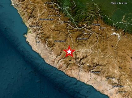
The 7.2 magnitude earthquake registered this Thursday, August 20 in Peru had its epicenter in the Ayacucho region, but the movement was felt hundreds of kilometers away. The Geophysical Institute of Peru (IGP) located the origin 35 kilometers north of Coracora, at a depth of 108 kilometers.
The earthquake occurred at 1:00 PM local time —6:00 PM GMT and 8:00 PM in mainland Spain— and reached an intensity III-IV in Coracora, according to data released by the Peruvian agency. In the initial reports, no victims or serious damages had been communicated.
Where is Coracora
Coracora is located in the province of Parinacochas, within the Ayacucho region, in southern Peru and in the heart of the Andes.
The location is especially relevant to understand why, despite the magnitude of the earthquake, a tsunami threat was not activated: the epicenter was inland, far from the Pacific coast.
The IGP took Coracora as a reference and located the epicenter 35 kilometers north of the locality.
However, there is a difference between the main agencies that analyzed the earthquake. The United States Geological Survey (USGS) calculated a magnitude of 6.7 and placed the epicenter 38 kilometers northwest of Upahuacho, also in the province of Parinacochas. AP reported this second measurement.
Differences between agencies are common in the initial estimates of an earthquake because they may use different seismic networks, scales, and calculation methods.
In which cities was the earthquake felt
The movement was felt in different points of southern Peru, including the regions of Ayacucho, Ica, and Arequipa. AP explicitly confirms that the tremor was felt in Ica and Arequipa.
It also reached Lima, located about 650 kilometers from Coracora, where the movement was perceived lightly, according to the information released after the earthquake.
In Coracora, the IGP did establish an intensity III-IV. This means that the movement could be clearly noticed by people indoors and produce oscillations of objects, but it is far from the higher levels of the intensity scale associated with severe destruction.
There is currently no confirmed equivalent official intensity for all the other cities where the earthquake was felt. It should not be confused that a tremor was perceived with having reached a certain intensity in that locality.