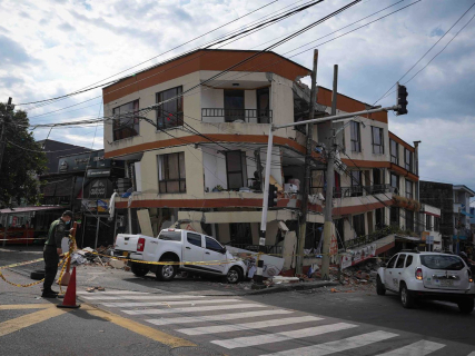

The earthquakes of magnitude 4.8 recorded in Alhendín and Gójar have returned to Granada a familiar feeling. The province is located in one of the areas with the highest seismic activity in the Iberian Peninsula and has gone through numerous earthquakes and sequences of small movements over the last few decades.
Contemporary Granada also has its own seismic history. Since 1979, the National Geographic Institute has documented earthquakes in the Vega, the Tropical Coast, the Baza basin, and the regions of Alhama and the Temple.
This list does not order the movements solely by their magnitude. It also takes into account their intensity, duration, location, social perception, and relevance to understand the earthquakes that are now affecting the metropolitan area again.
The seismic series of Fuente Vaqueros in 1979
The series of 1979 constitutes the first major seismic episode experienced by democratic Granada and one of the main precedents of the current situation.
The IGN catalog records numerous movements during those months distributed throughout the Vega and its surroundings. On June 20, a magnitude 4.5 earthquake occurred northwest of Beas de Granada. On July 30, the west of Alhendín shook with a magnitude of 3.7 and, just one day later, another of 3.9 was recorded north of Gójar.
The names of Alhendín and Gójar already appeared, therefore, in the Granada sequence 47 years ago. The seismologist José Morales has pointed out that the episode of 2026 presents similarities with that of 1979, although it is still early to determine if Granada is going through a new seismic swarm with comparable characteristics.
The Albuñol earthquake of 1980
On May 30, 1980, an earthquake of magnitude 4.0 shook the northeast of Albuñol, in the Tropical Coast. The IGN assigns it a maximum intensity of IV.
The movement showed that Granada's seismic activity is not limited to the Vega. The coastline and areas close to the Alboran Sea are part of a territory conditioned by the interaction between the Eurasian and African plates.
3. Lentegí, 1984: the largest surface earthquake in decades
The Lentegí earthquake of June 24, 1984 reached a magnitude of 5.0 and occurred at a depth of about five kilometers. Its maximum intensity was V.
It is one of the major recent instrumental earthquakes highlighted by the National Geographic Institute. For decades it was the largest surface earthquake recorded in the province since the arrival of democracy.
The difference between depth and magnitude is essential. A moderate and shallow earthquake can be felt more strongly and cause greater local effects than another numerically superior one originating hundreds of kilometers underground.
The Atarfe earthquake of 1986
On April 26, 1986, an earthquake of magnitude 4.0 was recorded west of Atarfe, at a depth of five kilometers and with a maximum intensity of V.
Its epicenter anticipated one of the points that would feature in the great seismic series of 2020 and 2021. Atarfe, Santa Fe, and Pinos Puente are located in an area crossed by active faults capable of generating numerous surface movements.
Agrón trembles again in 1988
On December 5, 1988, an earthquake of magnitude 4.0 and an approximate depth of seven kilometers was located southwest of Agrón. The movement reached a maximum intensity of V.
Agrón and its surroundings would reappear years later in the catalog of significant earthquakes in Granada. The area is located south of the Vega, near other municipalities with recurrent activity such as Ventas de Huelma, Cacín, and Santa Cruz del Comercio.
Santa Fe, 1996: an earthquake at a kilometer depth
On December 28, 1996, Santa Fe suffered an earthquake of magnitude 4.1. Its depth was just one kilometer and reached intensity V.
The shallow depth favored that the movement was clearly perceived. This episode is another direct precedent of the series that, almost 25 years later, would concentrate thousands of earthquakes between Santa Fe, Atarfe, Pinos Puente, and Cúllar Vega.
The Agrón earthquake of 1997
On February 24, 1997, an earthquake of magnitude 4.3 was recorded southwest of Agrón at a depth of six kilometers. The IGN attributes a maximum intensity of V to it.
It was one of the largest shallow earthquakes that occurred in Granada during the nineties. It also surpassed the movement located nine years earlier in the same area.
Nigüelas, 2010: the largest by magnitude, but at 623 kilometers
The earthquake recorded south of Nigüelas on April 11, 2010, occupies a unique place in this list. The IGN catalog assigns it a magnitude of 6.2 and a depth of 623 kilometers, while the seismotectonic documentation of the agency itself places it at a magnitude of 6.3.
It is the earthquake of greatest magnitude with an epicenter in Granada since the arrival of democracy. However, its extraordinary depth meant that its surface effects were much lower than those one would intuitively associate with a magnitude greater than 6.
The IGN explains that under Granada, earthquakes occasionally occur at more than 600 kilometers deep. In that same area, the Dúrcal earthquake, with a magnitude of 7.8, originated in 1954, although it also did not have the destructive capacity of an equivalent surface movement.
The swarm of Atarfe and Santa Fe in 2020 and 2021
Between December 2020 and August 2021, the Vega de Granada experienced its great contemporary seismic crisis. The IGN recorded more than 3,000 earthquakes.
Five consecutive movements reached magnitudes between 4.1 and 4.4. On January 23, 2021, one of 4.4 was recorded northwest of Santa Fe. Three days later, earthquakes of magnitudes 4.2, 4.4, and 4.1 occurred. On January 28, another of 4.4 took place.
Seven months later, the series produced a new earthquake of magnitude 4.5. The tremors were widely felt by the population and reached maximum intensities V and V-VI. Thousands of neighbors left their homes during the nights of greatest activity.
Alhendín and Gójar, 2026: two earthquakes of magnitude 4.8
The sequence that began in August 2026 closes, for now, this story.
The first major earthquake occurred at 23:04 UTC on August 14, at 1:04 in the early morning of the 15th in mainland Spain. It reached a moment magnitude of 4.8, had its epicenter northeast of Alhendín, and was very shallow.
The earthquake was felt in more than 500 localities in Andalusia, Murcia, Castilla-La Mancha, and Madrid. The IGN received more than 12,000 citizen questionnaires and documented non-structural damage and falling objects.
On August 18, Granada shook again with another earthquake of magnitude 4.8 and epicenter northwest of Gójar. Several significant movements were recorded afterward, including earthquakes of magnitudes 3.9, 4.2, and 4.0.
The episode left minor injuries, hundreds of calls to 112, preventive evacuations, and inspections of homes, public buildings, and monuments. The two movements in Alhendín and Gójar are the largest surface earthquakes recorded in Granada since the Lentegí one in 1984.
Why Granada concentrates so many earthquakes
The Granada basin is one of the areas with the highest seismic activity in the Iberian Peninsula. It is crossed by active fault systems and subjected to the effects of the convergence between the African and Eurasian plates.
The majority of earthquakes are of low magnitude and are never felt. Surface episodes close to populated centers can be felt with intensity even when their magnitude is moderate.
The historical comparison also does not allow predicting how long the sequence of 2026 will last nor if a larger earthquake will occur. It allows confirming another reality: from the Fuente Vaqueros series of 1979 to the earthquakes of Alhendín and Gójar, seismic activity has recurrently accompanied several generations of Granadinos.