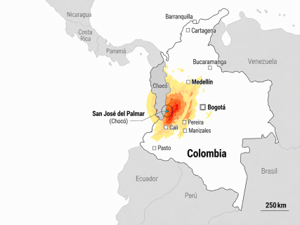

San José del Palmar has become one of the most searched names in Colombia after the earthquake that shook a good part of the country on Monday, August 10. This small municipality in the department of Chocó was located by the Colombian Geological Service (SGC) as the epicenter of the 7.4 magnitude earthquake recorded at 7:34 in the morning, with a revised depth of 103 kilometers.
Although some of the most serious consequences have occurred in large cities like Pereira, Cali, or Manizales, San José del Palmar also directly suffered the impact. The first municipal assessment confirmed collapsed houses and hundreds of damaged properties, in addition to landslides that complicated land communication with the outside.
Where is San José del Palmar
San José del Palmar is located in the southeast of the department of Chocó, in western Colombia. Its position is particular because it is situated precisely next to the departmental borders of Risaralda and Valle del Cauca, two of the territories especially affected by the earthquake.
The municipality borders Condoto to the north; Sipí and Nóvita to the south; Risaralda and Valle del Cauca to the east; and Nóvita to the west. It has an approximate area of 947 square kilometers and an important rural component. Its territory is also linked to natural spaces such as the Tatamá National Natural Park and the Serranía de los Paraguas.
This location also helps to understand its relationship with some of the hardest-hit areas. Under normal conditions, the road distance between San José del Palmar and Pereira is around 105 kilometers, while to Manizales it is about 151 kilometers. The road distance to Cali is around 247 kilometers. These are indicative references of usual travel and do not reflect the current situation of roads affected by landslides.
More than 500 affected homes
The mayor of San José del Palmar, León Fabio Marín, stated after the earthquake that the municipality had suffered significant material damage, although the first local assessment he could provide did not record any fatalities or injuries.
"It was too strong and long. There are many material damages, cracked houses," explained the mayor in statements collected by Caracol Radio.
Subsequently, Marín detailed to Noticias Caracol that at least 10 homes had completely collapsed and that more than 500 houses were estimated to be affected, mainly due to cracks and other structural damage. The census was still open, so those figures were preliminary.
Canal Trece also reported damage to buildings and infrastructure, problems with electricity supply and the aqueduct, and impacts on educational centers. Among them is the Normal Superior La Inmaculada, located in the district of La Italia.
The landslides complicate the arrival of aid
One of the main difficulties after the earthquake has been access to the municipality. The road that connects San José del Palmar with Cartago, in Valle del Cauca, was blocked by large landslides, hindering the passage of machinery, emergency services, and external aid.
Local authorities activated a Unified Command Post to coordinate the response and requested machinery to remove the landslides, as well as aerial support to assess hard-to-reach areas and facilitate possible evacuations.
The mayor requested help from the central government and the department of Chocó due to the limited municipal economic capacity. As he explained, the available fund for risk management had about 32 million Colombian pesos at the time of the emergency.
The geographical situation of San José del Palmar adds difficulties to the damage assessment: a significant part of its population and its homes are located outside the urban area, so the landslides and communication problems slow down the review of some rural communities.
The epicenter continues to register movements
San José del Palmar is also under the attention of seismologists due to the aftershocks following the main earthquake.
This Tuesday, August 11, the SGC recorded at 10:43 hours a new movement of magnitude 3.8 in San José del Palmar, within the seismic sequence that continues to affect the department of Chocó. During the morning, other movements had been recorded in the municipality itself and in nearby towns.
The Colombian Geological Service warns that aftershocks following an earthquake of this nature can continue for days, weeks, or even months as the affected area readjusts due to the rupture.
The municipality had already appeared previously in the seismic records of the country. On February 13, for example, the SGC located the epicenter of a 4.7 magnitude earthquake there at a depth of 105 kilometers, which was also felt in Manizales, Pereira, and various municipalities of Valle del Cauca. That movement did not leave material damages or victims.
A small municipality in the center of a national earthquake
The contrast is one of the particularities of the earthquake of August 10. The epicenter was located in a rural municipality of Chocó, but the consequences extended over a good part of the west and center of Colombia, reaching large urban areas at a considerable distance.
The SGC maintains after the technical review of the event a magnitude of 7.4 and a depth of 103 kilometers for the main earthquake. The institution has positioned it as the seismic event of greatest magnitude recorded in Colombia so far in the 21st century.
San José del Palmar remains meanwhile as one of the points where the damage assessment continues. The latest verifiable local balance speaks of hundreds of affected homes and access problems, but the authorities have warned since the beginning that the census was not closed, especially due to the difficulties in reaching some rural areas.