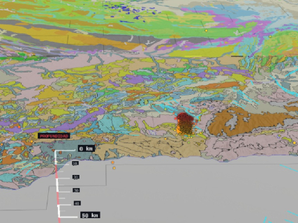

The Higher Council for Scientific Research (CSIC) has launched an open access viewer to follow the evolution of the seismic series recorded in the Vega de Granada since August 15.
The tool, called Seismicity 3D · Granada, allows representing earthquakes on different maps and graphically analyzing where they are located, at what depth they occur, and how the activity evolves over time.
The viewer is available for free on the CSIC website and uses data from official scientific organizations, mainly from the National Geographic Institute (IGN).
Viewer of the earthquakes in Granada, live
Source: Disaster and Emergency Advisory Group of the CSIC. If the viewer does not display correctly, it can be consulted directly at the Seismicity 3D · Granada platform.
What information does the CSIC viewer offer
The platform allows interactive consultation of various elements related to the seismic series:
- The location of the epicenters.
- The depth of the earthquakes.
- The chronological evolution of the activity.
- The distribution of the earthquakes on the ground.
- The proximity of the movements to the main active faults.
- The geological or satellite image of the affected area.
The three-dimensional representation makes it easier to observe the depth of the hypocenters and not just the position of the earthquakes on a flat map. This allows appreciating how the movements are distributed below the surface and how that distribution changes during the sequence.
Data from the IGN, the IGME-CSIC, and the Euro-Mediterranean Seismological Center
The information about the latest earthquakes comes from the National Geographic Institute, the competent body to officially locate and catalog seismic activity in Spain. The viewer also incorporates the position of the faults collected in the QAFI database, developed by the Geological and Mining Institute of Spain, integrated into the CSIC. This database compiles information about the main active faults of the Iberian Peninsula.
To provide a broader temporal context, the tool also includes information about earthquakes recorded between 2015 and 2026 based on data from the Euro-Mediterranean Seismological Center.
The combination of these sources allows comparing the current series with previous seismic activity and analyzing its spatial and temporal distribution.
The GADE advises the authorities since August 15
The project is managed by the Disaster and Emergency Advisory Group (GADE) of the CSIC. This team has been providing scientific and technical advice to the administrations responsible for managing the emergency since August 15.
The coordination corresponds to the emergency manager of the CSIC, Inés Galindo, and the coordinator of geological risks, Juan Carlos García. Researchers from the Geological and Mining Institute of Spain, the Institute of Marine Sciences of Andalusia, and the Eduardo Torroja Institute of Construction Sciences participate in the work.
The group analyzes the location, depth, and evolution of the earthquakes, as well as the distribution of the aftershocks and their relationship with nearby faults. It also participates in the meetings of the Advisory Committee of the Emergency Plan for Seismic Risk in Andalusia convened by the Junta.
Its function is to provide scientific information to those who must make operational decisions during the emergency. The action takes place within the CSIC Disaster and Emergency Advisory Protocol.
The viewer does not allow predicting new earthquakes
The incorporation of active faults into the map does not mean that the tool can accurately anticipate when or where a new earthquake will occur. Earthquakes cannot currently be predicted with precision. The viewer serves to study the activity already recorded, analyze the aftershocks, identify spatial patterns, and scientifically assess the possible interaction with nearby geological structures.
Therefore, the platform should be interpreted as a monitoring and analysis tool, not as an alert or prediction system. To know the latest confirmed movements and to communicate that an earthquake has been felt, the official reference continues to be the seismic information service of the IGN.