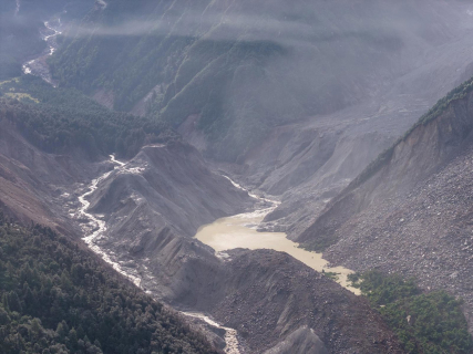
According to Nepali authorities, the country could suffer a second flood in the same valleys devastated on August 26. One of the lakes formed by the landslides has begun to drain without danger, but authorities are monitoring another larger nearby natural reservoir that continues to accumulate water.
This Friday, August 28, the danger of suffering another flood begins to increase. According to an official from the National Authority for Disaster Risk Reduction and Management of Nepal, it has been warned that the risk will continue until both lakes have been completely drained with full safety. However, the outcome will depend on whether the water exits progressively or suddenly breaks any of the barriers of rocks, ice, and sediments formed during the catastrophe.
The first lake has already begun to drain
The avalanche of ice and rock that caused the flood also displaced enormous amounts of sediment towards the waterways in the border area between Nepal and Tibet. Part of this material has blocked the flow of water and has created several temporary reservoirs upstream. Of these, there is one that worries authorities for having exceeded this Friday 2.5 million cubic meters, compared to an estimate of between 1.5 and two million that were evacuated the day before.
Since this morning, the water has begun to exceed the barrier and flow towards the Lhende Khola and the Trishuli system. Since then, Nepali authorities have decided to temporarily halt rescues for a few hours and also withdraw teams from the banks. Likewise, authorities have ordered the evacuation of the city for residents and workers, recommending them to move to higher areas. On the other hand, China has proceeded in the same way as Nepali authorities, advising its personnel and vehicles in the vicinity of the Gyirong border crossing to move away from the region.
The drainage has not ultimately caused another flood comparable to that of Wednesday, but it has alerted the population. According to the Nepal Army, the river level rose about 60 centimeters and teams resumed operations when the threat was considered manageable.
A second larger lake continues to accumulate water
The satellite images analyzed this Friday by the Nepalese authorities show a second lake near the site of the glacial collapse that raises the risk of suffering another flood. According to the information provided by the Nepalese authorities, it occupies a larger area than the first, continues to grow, and has no visible outlet.
Unlike the first reservoir that began to drain on the morning of this Friday, this second lake lacks a drainage channel, which could increase the pressure against the natural barrier and end up causing a second flood. The volume of water in this second lake has not yet been publicly determined, so there is also no reliable estimate of the magnitude of a possible discharge. However, the authorities state that a second flood is possible.
Since then, Nepal relies on satellite images to monitor its evolution and decide whether to order evacuation or not. However, the authorities are facing problems in monitoring the growth of the lake due to the high and dense cloudiness. Thus, the Government is considering installing more cameras and sensors downstream, especially near Timure. It is also analyzing the possibility of transporting equipment by helicopter due to the destruction of roads and bridges.
Which areas remain under surveillance
The authorities have concentrated the alert in Rasuwa and Nuwakot, the districts closest to the lakes and the upper stretch of the Bhote Koshi. Surveillance extends through the corridors of the Trishuli and the Narayani. The Nepalese Police have also requested preparation for a possible evacuation in vulnerable areas of Dhading, Gorkha, Chitwan, and Nawalparasi. During the alert on Friday, equipment and machinery located around Bidur and Trishuli Bazaar were removed.
The Department of Hydrology and Meteorology maintained this Friday the Narayani at its passage through Devghat at 4.3 meters, below the warning level, set at 7.3 meters, and the danger threshold, set at nine. This record reflects the situation at that specific point of the lower stretch, but does not eliminate the localized threat in the border lakes.
The channel that originates in the affected area continues through the Bhote Koshi and the Trishuli until it reaches the Narayani, known as Gandak upon entering India. For this reason, a significant rise would also be monitored downstream, although there is currently no forecast confirming a new flood into Indian territory.