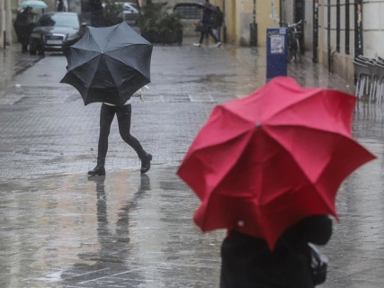

The Meteorological Service of Catalonia (Meteocat) has expanded this Saturday, October 17, the red alert for torrential rains to Barcelona and its metropolitan area, due to the forecast of precipitation that could exceed 40 liters per square meter in just 30 minutes. The alert affects seven Catalan counties, although the period of greatest danger varies by territory.
Civil Protection of the Generalitat has begun to send ES-Alert messages to the mobile phones of Maresme, Selva, and Vallès Oriental shortly after 1:00 PM. The alerts warn of the risk of torrential rains between 2:00 PM and 8:00 PM and ask the population to take extra precautions.
The seven counties of Catalonia under red alert for rains
The latest forecast from Meteocat places a danger level of 5 out of 6 on seven counties, distributed over two time slots.
- From 2:00 PM to 8:00 PM: Vallès Oriental, Maresme, and Selva.
- From 8:00 PM to 2:00 AM on Sunday: Barcelonès, Vallès Occidental, Baix Llobregat, and Garraf.
The episode will begin affecting the northeast of Catalonia with greater intensity during the afternoon and will subsequently move towards Barcelona and its metropolitan surroundings.
The forecast includes rains capable of exceeding 40 liters per square meter in half an hour, an intensity that can favor rapid water accumulation and flash floods in vulnerable areas.
Civil Protection sends ES-Alert alerts to mobiles
The first ES-Alert messages have begun to arrive this Saturday to the mobile phones of citizens located in the Maresme, Selva, and Vallès Oriental. The notifications warn of torrential rains during the afternoon and recommend taking self-protection measures.
The ES-Alert system allows authorities to send alerts directly to mobile devices located in a specific geographical area, without the need for users to be previously subscribed to a notification service.
Civil Protection has requested to reduce unnecessary travel and especially avoid passing through streams, ravines, and torrents, where flash floods may occur.
Barcelona, under red alert during the night
The forecast places the period of greatest danger in the Barcelonès, Vallès Occidental, Baix Llobregat, and Garraf between 8:00 PM on Saturday and 2:00 AM on Sunday.
In addition to the heavy rainfall, Meteocat warns of possible accumulations exceeding 90 liters per square meter in three hours in some areas, a circumstance that has prompted additional warnings for rain accumulation.
The director of Meteocat, Sarai Sarroca, had explained that the most intense rainfall would begin in Girona and the interior of Barcelona, before moving towards the coastline and central pre-coast, Central Catalonia, and the Pre-Pyrenees.
Possible impacts on Rodalies and rail transport
The storm could also affect train circulation. Renfe has warned of possible incidents in rail services during the day, especially in coastal areas exposed to the most intense rainfall.
The company recommends checking the status of services before starting a trip. The warning about possible impacts does not imply that all lines are interrupted.
Civil Protection is monitoring the episode to assess new measures based on the evolution of the storms. Citizens must heed the authorities' indications and consult the updated warnings from Meteocat.
The Servei Meteorològic de Catalunya (Meteocat) has expanded this Saturday, October 17, the red warning for torrential rains in Barcelona and its metropolitan area, due to the forecast of rainfall that could exceed 40 liters per square meter in just 30 minutes. The alert affects seven Catalan counties, although the period of greatest danger varies by territory.
Civil Protection of the Generalitat has begun sending ES-Alert messages to the mobile phones of Maresme, Selva, and Vallès Oriental shortly after 1:00 PM. The alerts warn of the risk of torrential rains between 2:00 PM and 8:00 PM and ask the population to take extra precautions.
The seven counties of Catalonia under red warning for rains
The latest forecast from Meteocat places a danger level of 5 out of 6 on seven counties, distributed over two time slots.
- From 2:00 PM to 8:00 PM: Vallès Oriental, Maresme, and Selva.
- From 8:00 PM to 2:00 AM on Sunday: Barcelonès, Vallès Occidental, Baix Llobregat, and Garraf.
The episode will begin affecting the northeast of Catalonia with greater intensity during the afternoon and will subsequently move towards Barcelona and its metropolitan area.
The forecast includes rains capable of exceeding 40 liters per square meter in half an hour, an intensity that can favor rapid water accumulation and sudden floods in vulnerable areas.
Civil Protection sends ES-Alert alerts to mobile phones
The first ES-Alert messages have begun to arrive this Saturday to the mobile phones of citizens located in the Maresme, la Selva, and the Vallès Oriental. The notifications warn of torrential rains during the afternoon and recommend adopting self-protection measures.
The ES-Alert system allows authorities to send alerts directly to mobile devices located in a specific geographical area, without the need for users to be previously subscribed to a notification service.
Civil Protection has requested to reduce unnecessary travel and especially avoid passing through streams, ravines, and torrents, where sudden floods may occur.
Barcelona, under red alert during the night
The forecast places the period of greatest danger in the Barcelonès, the Vallès Occidental, the Baix Llobregat, and the Garraf between 8:00 PM on Saturday and 2:00 AM on Sunday.
In addition to the heavy precipitation, Meteocat warns of possible accumulations exceeding 90 liters per square meter in three hours in some areas, a circumstance that has prompted additional warnings for rain accumulation.
The director of Meteocat, Sarai Sarroca, had explained that the most intense precipitation would begin in Girona and the interior of Barcelona, before moving towards the coastline and central pre-coast, central Catalonia, and the Pre-Pyrenees.
Possible impacts on Rodalies and rail transport
The storm could also affect train circulation. Renfe has warned of possible incidents in rail services during the day, especially in coastal areas exposed to the heaviest precipitation.
The company recommends checking the status of services before starting a trip. The warning about possible impacts does not imply that all lines are interrupted.
Civil Protection is monitoring the episode to assess new measures based on the evolution of the storms. Citizens must heed the indications of the authorities and consult the updated warnings from Meteocat.