Tsunami alert in Panama: which areas are at risk after the earthquake

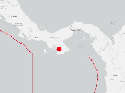
The 7.6 magnitude earthquake registered this Friday in Panama has put the focus on the Pacific coast and on the possibility of dangerous sea level changes occurring. The exposure of each area depends on its distance from the epicenter, the depth of the earthquake, and the characteristics of the coast.

1 minute

fotonoticia 20261009201815 1920

fotonoticia 20261009201815 1920

Add DEMÓCRATA to Google

Ask FREN

Published

Last updated

1 minute

Most read

The 7.6 magnitude earthquake registered this Friday, October 9, in Panama has raised concerns about the possible tsunami risk on the Pacific coast. The United States Geological Survey (USGS) has located the epicenter near the southern tip of the country, approximately 14 kilometers southwest of Pitaloza Arriba, according to preliminary information released by Associated Press.

The coastal areas near the earthquake's origin require special attention, although the magnitude of the quake alone does not allow for determining where flooding would occur. To know the real risk, it is necessary to consult the bulletins from civil protection authorities and specialized tsunami agencies.

Which areas of Panama may be exposed

The assessment should initially focus on the Pacific coasts near the epicenter, especially low-lying areas, beaches, ports, and river mouths.

The risk is not uniform along the coast. The depth of the water, the shape of the bays, and the orientation of the coast can modify the height and strength of the waves. There is not enough basis to present all the beaches of the Panamanian Pacific as areas under the same evacuation order.

When a tsunami may arrive

Tsunamis originating near the coast can reach land in a few minutes. Additionally, they do not always manifest as a large wave: they can also produce strong currents and abrupt changes in sea level.

In the event of an official alert, authorities recommend moving away from beaches and low coastal areas, heading towards higher ground, and not returning until authorized.

The existence of an alert does not confirm that the tsunami has reached land. Warnings may be modified or canceled as sea level records and the evolution of the phenomenon are analyzed.

More key points, information and questions with FREN

AI-GENERATED CONTENT

What are the tsunami alert and evacuation procedures in Panama according to current legislation?

I do not have specialized or systematic access to Panama's civil protection and disaster management regulations, and my focus is on the Spanish political-institutional system. Therefore, I cannot provide you with a reliable and detailed overview of the tsunami alert and evacuation procedures in Panama according to its current legislation (laws, decrees, regulations, official manuals, operational protocols, etc.) without risking legal inaccuracies or outdated information.

However, I can guide you on where and how to safely locate that information, and broadly explain what types of instruments usually exist in this area, so you can directly verify them with the competent Panamanian sources.

1. Where to look for official regulations and protocols in Panama

To precisely know the current tsunami alert and evacuation procedures, the safest approach is to consult the competent Panamanian authorities and their published regulations. I suggest these steps:

  • General legislation on civil protection or disaster risk management: many countries have a framework law on risk management, civil protection, or national emergency. In Panama's case, you should locate, on the National Assembly website or the Official Gazette, the laws and decrees related to:
    • Comprehensive disaster risk management.
    • National civil protection system or equivalent institutions.
    • National emergency and evacuation plans for natural threats.
  • Specific standards on marine threats or tsunamis: many legal frameworks refer to specific plans or protocols for certain risks (seismic, volcanic, hydrometeorological, tsunamis). It is advisable to review:
    • National or regional tsunami response plans.
    • Technical guides issued by civil protection, the competent ministry, or maritime authority.
    • Cooperation agreements with international agencies (e.g., UNESCO/IOC) in tsunami early warning systems.
  • Official civil protection site of Panama (or the country's designation): usually includes:
    • Standard operating protocols for issuing alerts.
    • Risk zoning maps on the coasts.
    • Detailed indications of evacuation routes and safe points.
    • Outreach materials for the population on what to do before, during, and after a tsunami.
  • Subnational instruments: provinces, coastal municipalities, or indigenous regions likely have:
    • Local emergency and evacuation plans.
    • Ordinances or regulations requiring evacuation route signage.
    • Coordination protocols with schools, hospitals, ports, and hotels.

2. What a legal tsunami alert procedure usually contains

Although I cannot detail the specific content of Panamanian legislation, in general terms, alert and evacuation protocols for tsunamis usually regulate:

  • Who detects and declares the alert:
    • Reference to seismic and oceanographic monitoring centers (national or international).
    • Authority responsible for activating the pre-alert, alert, and emergency phases.
  • Official channels for alert dissemination:
    • Coastal siren systems.
    • Messages to mobiles, radio, and television.
    • Social networks and institutional websites.
  • Response phases:
    • Enhanced monitoring after a potentially tsunami-generating earthquake.
    • Issuance of preventive warning and preparation to evacuate.
    • Mandatory evacuation order in risk zones.
  • Evacuation and safe zones:
    • Minimum height or distance from the coast considered safe.
    • Official marked evacuation routes.
    • Responsibilities of local authorities, police, firefighters, and health services.
  • Protection of vulnerable groups:
    • Specific protocols for schools, hospitals, and residences.
    • Measures for people with reduced mobility or without their own transportation.

3. What I can do for you

My specialization is the Spanish political and institutional system. I can help you, for example, to:

  • Explain how civil protection and tsunami risks are regulated in Spain.
  • Compare, conceptually, legal disaster management frameworks.
  • Analyze draft laws, decrees, or other normative instruments (Spanish) on emergencies.

If you need a specific analysis about Panama, I would recommend complementing these guidelines with direct consultation of the official Panamanian government pages, its civil protection, and the Official Gazette, or with advice from public law specialists from that country.

What powers and attributions does the United States Geological Survey (USGS) have in managing international alerts?

The United States Geological Survey (USGS) is primarily a federal scientific agency. Internationally, its role in alert management is based on producing and sharing high-quality technical information about earthquakes, volcanoes, tsunamis, and other geological hazards, but without exercising legal authority over other States or directing civil protection responses.

Regarding earthquakes, the USGS operates the National Earthquake Information Center (NEIC), which quickly locates relevant earthquakes worldwide, calculates their magnitude, depth, and basic characteristics, and disseminates that data within minutes. Through networks like the Global Seismographic Network (GSN), which integrates about 150 stations globally distributed, the USGS collects and analyzes seismic signals used by both U.S. authorities and geological services and alert centers of other countries. This information serves as a basis to assess potential damage, casualty probability, and possible cascading effects (e.g., tsunami risk), but emergency decisions belong to each State.

In volcanic risk, the USGS manages the Volcano Hazards Program and the Volcano Disaster Assistance Program (VDAP). Its functions include instrumental monitoring of volcanoes (seismicity, deformation, gases, thermal signals), developing forecast models, and especially providing technical assistance to observatories and geological services of other countries during eruptive crises. The USGS can deploy teams, install sensors, help interpret data, and prepare hazard maps. However, issuing volcanic alert levels directed at the population and adopting measures such as evacuations remain the responsibility of national or local authorities.

Regarding tsunamis, the USGS plays an essential role in the detection and characterization of the earthquake that may generate them (epicenter location, magnitude, rupture type, depth, etc.). Based on this, other specialized agencies evaluate tsunami risk. In the U.S. system, operational authority lies with NOAA through the National Tsunami Warning Center and the Pacific Tsunami Warning Center, which integrate USGS seismic data with tide gauges, ocean buoys, and propagation models to issue or cancel tsunami warnings. That is, in this chain, the USGS provides the seismic and hazard component, while NOAA manages marine and coastal alerts.

In global early warning systems, the USGS contributes mainly in four areas: observation, rapid analysis, data sharing, and capacity building. On one hand, its networks and instruments feed databases used by regional and national alert centers worldwide. On the other, it openly shares information on significant events and develops impact products (e.g., rapid estimates of damage and probable casualties) used by governments, humanitarian aid organizations, and UN agencies as input to decide deployments and international support.

Coordination with UNESCO‑IOC (Intergovernmental Oceanographic Commission of UNESCO), which is the mandated body to coordinate tsunami warning systems, occurs mainly through data provision and participation in networks and exercises. UNESCO‑IOC structures cooperation among regional and national alert centers in the Pacific, Indian Ocean, Caribbean, and Atlantic/Mediterranean, defines standards, and promotes interoperability. The USGS can be a key provider of seismic information and knowledge but does not act as a “global alert center”; the formal architecture relies on centers designated by States within those IOC frameworks.

Regarding the UN and humanitarian aid, the USGS integrates its work into the U.S. Government's external programs. Specialized teams, such as those dedicated to seismic disasters, prepare rapid impact assessments shared with federal agencies, international partners, and, when appropriate, United Nations coordination mechanisms. Its contribution is to provide technical “situational awareness”: intensity maps, damage scenarios, identification of most vulnerable areas, etc., which serve as a basis for humanitarian actors' decision-making, but without the USGS directing the response.

Finally, the USGS maintains extensive bilateral and multilateral cooperation with geological services of other countries. This cooperation includes data exchange, jointly operated stations, communication protocols in emergencies, hazard mapping projects, training, and drills. In a specific crisis, the USGS can deploy at the affected country's request to reinforce monitoring or analysis. But even in those cases, its role is that of an external scientific advisor: authority over population alerts, evacuation orders, and emergency management remains with the government and civil protection of the affected State.

In summary, the USGS is a central scientific actor in the global infrastructure for monitoring and early warning against geological risks: it detects, measures, interprets, and advises. Its powers do not include commanding other States or replacing national geological services or official alert centers; its influence is exercised through the quality of its data, speed of analysis, and technical cooperation capacity.

What requirements and protocols must Panamanian authorities follow to issue an evacuation order in the face of tsunami risk?

I specialize in the Spanish political and institutional field (regulations, parliamentary procedures, public administrations, and political actors in Spain), and I do not have a specific, reliable, and systematic reference base on the requirements and protocols that Panamanian authorities must follow in the face of tsunami risk.

The question you raise requires detailed knowledge of:

  • The Panamanian legal framework for civil protection and disaster management (laws, decrees, and regulations in force in Panama).
  • National and local emergency plans specific to tsunamis (for example, coastal evacuation plans, alert levels, coordination with regional monitoring centers, etc.).
  • Internal operational procedures of Panamanian authorities (civil protection services, police, maritime authorities, municipalities, etc.), which are usually regulated by their own regulations and technical protocols of that country.

All this is part of the law and emergency management of a specific State different from Spain, and it is outside the domain for which I am designed. Therefore, I cannot give you a detailed, step-by-step description of:

  • Which specific Panamanian authority has the formal competence to issue the evacuation order.
  • What prior legal requirements (declaration of state of emergency, technical reports, alert levels) its legislation demands.
  • Which communication channels and legal forms (resolutions, decrees, administrative orders) must be used.
  • What coordination protocols with other countries or international alert systems are foreseen.

What I can do is indicate, in a very general way and not specific to Panama, what elements civil protection frameworks in many countries usually consider when it comes to evacuation orders due to tsunamis:

  • Clear legal basis: a civil protection or risk management law that empowers certain authorities (central government, governors, mayors, national civil protection) to order mandatory evacuations under certain circumstances.
  • Linkage with early warning systems: protocols that connect the issuance of the evacuation order with warnings from seismic and oceanic monitoring bodies (for example, regional tsunami warning centers), usually through predefined thresholds and alert levels.
  • Pre-established evacuation plans: maps of risk zones, routes, and safe points, with instructions on means of transport, priorities (children, elderly, people with reduced mobility), and coordination among security forces and emergency services.
  • Communication channels to the population: coordinated use of sirens, mass SMS messages, community radios, television, social networks, and loudspeaker systems to disseminate the evacuation order and associated instructions.
  • Chain of command and inter-institutional coordination: prior definition of who makes decisions, who executes them, and how security forces, rescue bodies, local authorities, health services, and, if applicable, armed forces coordinate.
  • Post-event evaluation and protocol review: after a risk episode or drill, mechanisms to review what worked and what did not, and adapt protocols.

However, to reiterate: these points are only general principles drawn from how civil protection systems usually operate in many countries, not a normative or procedural description of the Panamanian case. To obtain the precise and legally reliable information you seek, it would be appropriate to consult directly:

  • Panama's legislation on civil protection and risk management.
  • The competent national authority (for example, Panama's national civil protection system, if it exists, or the responsible ministry).
  • Its official emergency plans published on government portals.

In summary: I cannot detail the specific requirements and protocols that Panamanian authorities must follow to issue an evacuation order due to a tsunami, because that information lies outside the Spanish political-institutional scope for which I am designed.

On the other hand, I can help you with issues such as:

  • How emergencies and civil protection are regulated in Spain.
  • What competencies the different administrations here have in the face of natural risks.
  • Which Spanish laws and operational plans regulate disaster management.
What regulations govern civil protection and emergency management in Spain against natural risks such as tsunamis? How do the State and autonomous communities coordinate in Spain in case of activation of an emergency plan for floods or tsunamis? What powers do Spanish municipalities have to order preventive evacuations due to serious risks to the population?

Play

Test your knowledge with FREN!

How much do you know about this topic? Answer the following 3 questions.

What was the magnitude of the earthquake recorded in Panama on Friday, October 9?

Question 1 of 3

Where did the United States Geological Survey locate the epicenter of the earthquake?

Question 2 of 3

What is recommended for the population to do in the event of an official tsunami alert?

Question 3 of 3