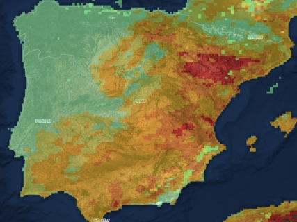
Copia de Fire map in Spain today, Friday, August 28: El Saler concentrates the emergency while the last major hotspots evolve favorably.

The fire declared in the Devesa de El Saler remains active and maintains evacuations, while Pina de Montalgrao is already extinguished and Segorbe and Collserola remain controlled.

5 minutes

mapa incendios españa 28 agosto

mapa incendios españa 28 agosto

Add DEMÓCRATA to Google

Ask FREN

Published

Last updated

5 minutes

Most read

The wildfire map of this Friday, August 28, places the main focus of attention on the Devesa de El Saler, in Valencia. The fire declared during the afternoon of Thursday remains active and has forced the evacuation of the hamlet of El Saler and several campsites located in the surroundings of the Albufera Natural Park.

The situation contrasts with the favorable evolution of other fires that have marked the last few days. Pina de Montalgrao has already been extinguished, while the fires in Segorbe and Collserola remain controlled and only maintain surveillance and consolidation work on the affected areas.

Official map of active fires from Copernicus

The European Forest Fire Information System, EFFIS, offers a public viewer to locate fires, hot spots, and burned areas in Spain and the rest of Europe.

The map allows observing the perimeters detected by satellite, but the appearance of a hot spot does not necessarily mean that there is an active wildfire. To know the official status of each emergency, the regional emergency services of 112 and firefighting must also be consulted.

El Saler concentrates the main focus of attention

The wildfire declared in the area of the Gola de Pujol, in the Devesa de El Saler, remains active this Friday. The firefighting teams have worked throughout the night to stop the fire and prevent possible reactivations within an area of high environmental value.

The emergency forced the evacuation of the hamlet of El Saler and two nearby campsites. A total of 161 people were relocated to the La Fonteta pavilion, while situation 2 of the Special Plan against the Risk of Wildfires remains activated.

The affected area is around 37 hectares, although the figure is still pending a definitive measurement. Several roads and accesses in the affected area remain closed while the teams maintain the deployed operation.

Pina de Montalgrao is extinguished

The fire declared on Wednesday in Pina de Montalgrao, in Castellón, has been extinguished after a rapid intervention by the emergency services. The fire was stabilized shortly after its declaration and the favorable evolution allowed the emergency to be closed during the same day.

The ground and air resources mobilized managed to contain the advance of the flames before the fire reached a larger extent, in a new action that prevented the spread of the fire through the forest mass of the surroundings.

Segorbe remains controlled after affecting 633 hectares

The fire in Segorbe, caused by the fall of a lightning bolt and spread through the surroundings of the Sierra Calderona, remains controlled after affecting 633 hectares.

The device continues to carry out surveillance and monitoring tasks over the wide affected perimeter. The situation has left behind the emergency phase, although the fire has not yet been declared extinguished.

Collserola maintains the control phase

The fire declared this week in the surroundings of the Natural Park of the Sierra de Collserola, in Barcelona, remains controlled after affecting 54 hectares. During the emergency, it was necessary to establish preventive confinements and evacuate several homes near the forest area.

The work is now concentrated on monitoring the perimeter and eliminating possible hot spots. The favorable evolution has allowed for a reduction in the device deployed during the first hours of the fire.

Pinofranqueado remains under surveillance in Las Hurdes

The fire in Pinofranqueado, in the Cáceres region of Las Hurdes, remains controlled after several days of emergency. The fire affected thousands of hectares and forced the evacuation of various hamlets before the evolution allowed for the lifting of restrictions.

The current phase focuses on monitoring the perimeter and preventing possible re-ignitions, while the recovery of the areas and nuclei affected by one of the most significant fires recorded during August continues.

To know the specific situation of a municipality, these sources should be used:

  • EFFIS-Copernicus: satellite location, perimeters, and hot spots.
  • Civil Protection: emergencies and state deployment.
  • DGT: closed or affected roads.
  • AEMET: daily fire risk level.
  • Autonomous services of 112: official status of each fire, evacuations, and confinements.

Searcher: check the fire risk today in your municipality

Enter the name of your municipality in the search engine to know the level of forest fire risk forecasted today according to AEMET. The search engine is updated daily and shows the situation in more than 8,000 Spanish municipalities through the Forest Fire Danger Index (IPIF).

↔ Slide the table sideways to check all the days.

Slide the table sideways to check all the days.

The system classifies the risk into six levels:

  1. Very low.
  2. Low.
  3. Moderate.
  4. High.
  5. Very high.
  6. Extreme.

Each municipality appears classified according to the predominant level expected for that day.

How the fire risk map works

The search engine uses the information published daily by the State Meteorological Agency through its *Forest Fire Danger Index (IPIF).

This system combines different meteorological variables that directly influence the possibility of a forest fire starting and spreading, among them:

  • Temperature.
  • Relative humidity.
  • Wind speed and direction.
  • Accumulated precipitation.
  • State of the vegetation.

With all this data, AEMET prepares a forecast map that allows estimating the level of danger existing at each point of the national territory.

What each risk level means

The index used by AEMET divides the fire risk into six categories:

  • Very low* and low indicate that the meteorological conditions are not very favorable for the start of a large fire.
  • The moderate level advises taking extra precautions, especially in activities that may generate sparks or flames.
  • When the risk becomes high, very high, or extreme, the chances of a fire starting and spreading rapidly increase considerably, especially if episodes of intense wind or very high temperatures coincide.

More key points, information and questions with FREN

AI-GENERATED CONTENT

What are the legal and administrative procedures necessary to declare a forest fire extinguished in Spain?

In Spain, there is no single detailed state procedure to “sign off” the extinction of a forest fire, but rather a common basic framework on which each autonomous community develops its own protocol. The declaration of a fire as extinguished is the result of a technical-operational process and an administrative act by the competent emergency authority.

1. Basic legal framework

Forest fire management is supported, among other regulations, by:

  • Law 43/2003, on Forests, amended by Law 10/2006 and Royal Decree-Law 15/2022, which sets the basis for forest policy and the prevention and fight against forest fires.
  • The Basic Guideline for Civil Protection Planning for Emergencies due to Forest Fires, approved by Royal Decree 893/2013, of November 15 (partially amended by later regulations), which establishes common criteria for autonomous plans.
  • The State Civil Protection Plan for Emergencies due to Forest Fires, approved by Agreement of the Council of Ministers on October 24, 2014, published by Resolution of October 31, 2014 (BOE-A-2014-11493), which coordinates the action of the General State Administration when support is requested.

On this basis, each community approves its Special Autonomous Plan for Forest Fires (and, where applicable, local plans), which specify who declares the extinction and with what formalities.

2. Operational phases of the fire

The Basic Guideline and the State Plan define the main fire situations:

  • Forest fire: fire spreading uncontrolled over forest fuels located in the forest, including adjacent urban-forest transition areas.
  • Controlled fire: the fire’s advance and spread have been isolated and stopped within control lines.
  • Stabilized fire: the fire, although not yet controlled, evolves within the planned control lines, according to extinction efforts.
  • Extinguished fire: situation in which there are no longer any ignited materials in or within the fire perimeter and no reproduction is foreseeable.

The key criterion to declare extinction is therefore technical: absence of hot spots capable of reigniting within the perimeter.

3. Administrative competences

a) Autonomous communities

Ordinary competence in prevention and extinction of forest fires is autonomous. The community’s forest and emergency services:

  • Direct the extinction and coordinate their own resources and those assigned to them.
  • Appoint the technical director of extinction or equivalent figure.
  • Regulate in their special plan who signs the declaration of control and extinction.

It is usual that the formal declaration of extinguished fire is adopted by the autonomous body competent in emergencies or environment (for example, a general directorate or territorial service head), upon proposal of the extinction director.

b) General State Administration

The State acts complementarily:

  • Provides extraordinary resources (Military Emergency Unit, state aerial means, etc.) according to the State Plan.
  • Participates in coordination committees when the fire exceeds autonomous capacity or affects several communities.

However, the decision to declare a fire extinguished corresponds, in practice, to the affected community or communities; the State does not administratively “extinguish” the fire but coordinates and supports.

c) Local entities

Municipalities may have municipal emergency plans, their own firefighters and local police who intervene in first response and population protection. In small fires, some plans foresee that the local authority declares extinction when activation of the autonomous plan is not necessary; but in large fires, this competence is integrated into the autonomous device.

4. Procedures to declare a fire extinguished

Although details vary by community, the typical scheme is:

  • Technical verification on site: the extinction director orders a thorough reconnaissance of the perimeter, checking hot spots and evaluating weather forecasts.
  • Extinction proposal: when it is considered that reproduction is not possible, the extinction command proposes declaring the fire extinguished, documenting affected area, time, resources used and possible residual risks.
  • Extinction report or record: a technical report (often standardized) is drawn up that serves as the basis for the administrative file. It may be signed by the extinction chief and the heads of the different sectors.
  • Administrative resolution: the competent autonomous body issues the resolution or agreement declaring the forest fire extinguished, with effects on:
    • Complete demobilization of the operation.
    • Closure of the emergency phase in civil protection.
    • Start of damage assessment, restoration work and, where applicable, sanctioning or liability proceedings.
  • Notification and registration: the extinction is communicated to civil protection services, affected municipalities and other bodies (for example, forestry, cadastre or environment) and data are entered in the corresponding forest registers and inventories.

In summary, declaring a forest fire extinguished in Spain requires the concurrence of a technical judgment (no reasonable possibility of reactivation) and a formal act by the emergency authority, within the framework of autonomous plans and the civil protection system established by basic state regulations.

What specific competences does the State Meteorological Agency (AEMET) have in the management of emergencies due to fires?

The State Meteorological Agency (AEMET) does not direct fire emergencies nor decide evacuations, but it plays a key technical role within the National Civil Protection System: it provides meteorological information and advice that allows risk forecasting, response planning, and supports decision-making in forest fires and other emergencies related to atmospheric phenomena.

Basic legal framework of AEMET's competences

Royal Decree 186/2008, which approves the Statute of the State Meteorological Agency, configures AEMET as the body responsible for executing the State's meteorological and climatological policy and attributes to it:

  • The status of State meteorological authority and aeronautical meteorological authority (articles and preamble consulted in Royal Decree 186/2008).
  • Competences directly linked to the safety of people and property and support to civil protection, as well as maritime and air traffic, which justifies that some Agency positions are reserved for functions related to emergencies and civil protection.

Law 17/2015, of July 9, on the National Civil Protection System places AEMET as an essential information provider in the National Civil Protection Information Network, managed by the National Center for Monitoring and Coordination of Civil Protection Emergencies (Law 17/2015). This network integrates the data necessary to anticipate and manage emergencies, including fires.

Specific functions in forest fires

The State Civil Protection Plan for Emergencies due to Forest Fires, approved by Agreement of the Council of Ministers on October 24, 2014 (Resolution of October 31, 2014), explicitly cites the AEMET Statute as one of the reference regulations and includes it among the bodies concerned with prevention, surveillance, monitoring and extinction of fires.

Within this framework, AEMET's operational competences in forest fires are specified as:

  • Specialized meteorological prediction and monitoring: preparation of forecasts of temperature, wind, humidity, dry storms and other factors that condition fire behavior. The Interior Ministry details that in the State Coordination and Direction Committee (CECOD) for forest fires, AEMET presents forecasts of unfavorable meteorological conditions and their possible impact on fire evolution (Interior note of 08/12/2025).
  • Calculation and dissemination of the fire danger index: in 2026 AEMET launches the new Forest Fire Danger Index (IPIF), which combines meteorological variables with data on vegetation status, soil moisture and surface types, with 1 km resolution and six risk levels (very low to extreme) (MITECO, 05/28/2026). These daily maps serve as a basis for autonomous and state devices for preventive planning, use restrictions and reinforcement of resources.
  • Technical advice in coordination bodies: AEMET is part of the CECOD and integrates into the CECOPI when the emergency requires it, providing real-time information on meteorological evolution, wind changes and favorable windows for extinction. Demócrata explains that when the emergency is meteorological, AEMET technicians participate in these integrated operational coordination centers.
  • Feeding national information systems: its data feed the monitoring carried out by the National Coordination Center for Forest Fire Information (dependent on MITECO) and the National Civil Protection Alert Network.
  • Preventive information to the population: AEMET issues warnings of adverse meteorological phenomena (heat waves, wind, dry storms) that increase fire risk. Although mobile alerts ES-Alert are activated by Civil Protection, those decisions are largely based on AEMET information, which provides “the meteorological information that serves as the basis for decision-making” in large fires or extreme phenomena, as summarized by Demócrata.

Role in state and autonomous plans

The State Forest Fire Plan relies on AEMET to:

  • Maintain a common system of danger indices and technical information used homogeneously in autonomous plans.
  • Provide, through the National Civil Protection Information Network, data and analyses that autonomous plans incorporate in their operational levels (situations 0, 1, 2 and 3) and in the activation of preventive measures.
  • Serve as a scientific reference for the anticipation of extreme risk episodes, on which communities and the State adapt surveillance, mobilization of aerial and ground resources and forest use restrictions.

Emergencies from other fires and risks

Beyond forest fires, Law 17/2015 includes adverse meteorological phenomena as one of the major risks of the National Civil Protection System. In any emergency where weather is decisive —urban fires favored by extreme wind, industrial incidents with smoke dispersion, major storms, DANA, etc.— AEMET performs analogous functions:

  • Provide detailed forecasts to the Directorate General of Civil Protection and Emergencies.
  • Integrate its data into the National Civil Protection Information Network.
  • Participate in coordination bodies when the nature of the risk is meteorological.

In summary, AEMET is the meteorological pillar of the National Civil Protection System: it does not direct the fire operation, but its competences in observation, prediction and risk assessment are essential to plan, coordinate and safely execute the response to forest fires and other weather- and climate-related emergencies.

What other major fires have recently affected the Natural Park of l’Albufera and what has been their historical impact?

In the sources consulted, only one large recent fire is clearly documented within the Natural Park of l’Albufera de València: the Devesa de El Saler fire of August 2026. Alongside it, some minor episodes in the same area are mentioned, but no detailed chronology of large fires (GIF type, hundreds of hectares) in the Albufera between 2008 and 2022 is found in this documentation. This forces focusing the analysis on the 2026 episode and the broader historical context of wetland degradation.

The large fire of the Devesa de El Saler in 2026

On August 27, 2026, a forest fire was declared in the Devesa de El Saler, in the Gola de Pujol area, fully within the Natural Park of l’Albufera. The fire forced the evacuation of the El Saler hamlet, two campsites and an apartment tower, and the closure of the CV-500 road to avoid risks to the population and facilitate emergency services work.

According to published information, the fire was stabilized on August 28 at 3:55 p.m., with about 37 hectares affected and an approximate perimeter of 5.42 kilometers. More than 270 professionals participated in the extinction efforts, with 40 ground resources and 10 aerial resources, including municipal firefighters, the Generalitat, the Ministry for Ecological Transition and the UME.

The burned area is part of the coastal forest of the Devesa, an ecosystem of dunes, pine forest and scrub that separates the lagoon from the Mediterranean. The forestry engineer and professor at the Polytechnic University of Valencia Eduardo Rojas emphasizes that the damage is not irreversible, but estimates that the affected area may need around 20 years to reach a state similar to that before the fire. This assessment coincides with the idea that, although the Mediterranean pine forest and part of the scrub regenerate, the dune structure and vegetation cover take decades to fully recover their functionality.

Other fire episodes in the area

The reviewed documentation also records a precedent in the same strip of the Devesa: a fire in October 2023, in the Gola de Pujol avenue area, for which the Valencia Court sentenced a man after it was proven he deliberately set fire to the forest mass. That fire was very small (affected 0.0003 hectares) and was quickly extinguished thanks to a neighborhood alert, but it illustrates the repetition of fire outbreaks in a very sensitive environment under strong urban and recreational pressure.

Beyond these specific cases, official notes and the City Council of Valencia emphasize that the Devesa is an area with high structural fire risk. Hence the deployment of a broad preventive system:

  • Update of the Local Forest Fire Prevention Plan, with special emphasis on the Devesa and the Natural Park of l’Albufera.
  • Implementation of SIDEINFO water cannons (at least 8, expanded to 11), capable of launching 3,000 liters per minute to moisten the forest mass on days of extreme risk.
  • Periodic closures of access to the Devesa when the Generalitat decrees pre-emergency due to extreme fire risk, and reinforcement of surveillance with firefighters, Local Police, forest rangers and Civil Protection volunteers.
  • Preventive silviculture plans (pruning of dry branches, control of bramble, removal of eucalyptus in sensitive areas, creation of safety strips in the urban-forest interface).
Ecological and historical impact on l’Albufera

Although the question refers to years such as 2008, 2012, 2014, 2018 or 2022, the consulted material does not show a detailed historical series of large fires that have massively affected the Natural Park of l’Albufera in those years. However, a sustained concern by the Generalitat and the City Council is noted regarding:

  • The vulnerability of the Devesa forest as a natural firebreak between the sea and the lagoon, key to the stability of the dune system.
  • The risk that fires, even if relatively contained in surface, combine with other factors of historical wetland degradation: coastal urbanization, beach regression, hydrological alterations, pollution and pressure on the rice fields.
  • The need to manage vegetation to avoid fuel continuity that favors extreme behavior fires, as already seen in other Mediterranean natural spaces.

In this sense, recent fires in the Devesa have not been, by number of hectares, the main cause of the historical degradation of the Albufera, but they have reinforced the perception that the wetland is exposed to a scenario of increasing risk. Administrations and experts agree that the key is not only to put out fires, but to combine active prevention, public use management and habitat restoration so that the Devesa, the malladas and the rice fields maintain their resilience capacity against future fire episodes.

Play

Test your knowledge with FREN!

How much do you know about this topic? Answer the following 3 questions.

What approximate area has the El Saler fire burned according to available reports?

Question 1 of 3

What does it mean that a fire is stabilized?

Question 2 of 3

What meteorological variables does AEMET use to calculate the Forest Fire Danger Index (IPIF)?

Question 3 of 3

Hola, soy Fren. ¿Cómo te ayudo?