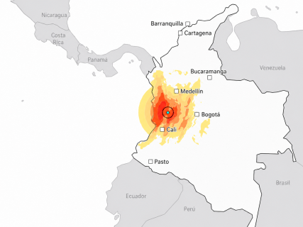
The earthquake in Colombia, in graphics: map of the epicenter, magnitude, depth, and affected cities

The earthquake of magnitude 7.4 that shook Colombia had its epicenter near San José del Palmar, in the department of Chocó. These maps and graphs allow understanding where it occurred, what intensity it reached, how much population was exposed, and why its great depth was decisive.

7 minutes

ChatGPT Image 10 ago 2026, 20 51 38

ChatGPT Image 10 ago 2026, 20 51 38

Add DEMÓCRATA to Google

Ask FREN

Published

Last updated

7 minutes

Most read

The earthquake of magnitude 7.4 that shook the west of Colombia this Monday, August 10, 2026, occurred at 7:34, local time, and had its epicenter near San José del Palmar, a locality in the department of Chocó located near the border with Valle del Cauca.

The tremor was felt in a large part of the country and caused significant damage in cities such as Pereira, Cali, Manizales, Armenia, and Quibdó. The movement was also perceived in Bogotá and in areas of neighboring countries, especially Panama and Ecuador.

The following maps and graphs explain the main characteristics of the earthquake in Colombia: the exact location of the epicenter, its depth, the intensity of the shaking, the estimated number of people exposed, and its position among the largest earthquakes recorded in the history of the country.

The earthquake, in four data points

A very strong and exceptionally deep shake

The quake occurred at 7:34, Colombian time, near San José del Palmar, in Chocó. The depth helped to cushion the intensity at the surface, but extended the perception of the tremor over a huge area.

7.4moment magnitude
103 kmdepth, according to the SGC
7:34local time on August 10
VIIestimated maximum intensity (MMI)

Sources: Colombian Geological Service and USGS. The USGS places the revised depth at 107 km; the SGC, at 103 km.

Where it occurred

The epicenter, in western Colombia

Schematic location of the main nearby cities and the area with the highest estimated shaking.

Epicenter near San José del Palmar and cities in western Colombia. EpicenterSan José del Palmar CaliPereiraManizalesBuenaventuraQuibdóBogotá PACIFIC OCEAN Greatest shakingStrong shakingModerate shaking

Schematic map of own elaboration. The circles explain the propagation pattern and do not replace the USGS technical ShakeMap.

Exposed population

More than 34 million felt the shake

USGS estimate by intensity on the modified Mercalli scale (MMI).

VII · Very strong1.56 million VI · Strong8.89 million V · Moderate17.08 million IV · Light6.47 million III · Weak4,750 08.5 million17 million

Source: USGS PAGER / ShakeMap. Rounded values.

Why depth matters

More energy, but much farther from the surface

The Armenia earthquake of 1999 released much less energy, but occurred only 17 kilometers away and was devastating. The one in 2026 originated six times deeper.

SURFACE 20 km60 km100 km 6.2Armenia, 199917 km deep 7.4Chocó, 2026107 km according to USGS Energy dissipates before reaching the surface

The size of the circles approximately represents the magnitude; the magnitude scale is logarithmic. Depth of 2026: USGS. Data from Armenia: USGS historical catalog.

Historical perspective

One of the largest earthquakes recorded in Colombia

The magnitude 7.4 of 2026 only ranks below, among the highlighted major precedents, the Tumaco earthquake of 1979 and the great quake off the coast in 1906.

Colombia–Ecuador coast, 19068.8 Tumaco, 19797.7 Chocó, 20267.4 Murindó, 19927.2 Armenia, 19996.2

Source: significant earthquake catalog of the USGS. The comparison selects relevant episodes and does not constitute an exhaustive list.

Intensity scale

What a VII intensity means

MMI Intensity Shake Estimated population Expected damage
VII Very strong 1.56 million Moderate damage; vulnerable buildings may suffer significant damage
VI Strong 8.89 million Light damage; falling objects and cracks in weak constructions
V Moderate 17.08 million Very light damage; movement is widely perceived
IV Light 6.47 million No probable damage

Intensity describes the effects of the shake in each place; it is not the same as magnitude, which measures the total size of the earthquake.

Where was the epicenter of the earthquake in Colombia

The Colombian Geological Service located the focus of the earthquake at an approximate depth of 103 kilometers, while the United States Geological Survey, the USGS, calculated it at 107 kilometers.

The area is close to the so-called Coffee Axis and to densely populated urban centers such as Pereira, Manizales, Armenia, and Cali. This proximity helps explain why, despite being a deep earthquake, the shaking caused significant damage in various cities.

The map above shows the approximate position of the epicenter and its relation to the main affected localities in western Colombia.

How many people were exposed to the earthquake

USGS estimates indicate that more than 34 million people were exposed to some degree of shaking. Most experienced intensities ranging between levels IV and VI on the modified Mercalli scale.

Around 1.56 million people were exposed to an intensity VII, considered "very strong" and capable of causing moderate damage, especially in vulnerable buildings. Another 8.89 million endured an intensity VI, corresponding to a strong shaking, while approximately 17 million were subjected to an intensity V.

Intensity does not measure the total size of the earthquake, but rather the effects it produces in each location. Therefore, the same shaking can have very different consequences depending on the distance to the epicenter, the type of soil, and the resistance of the buildings.

Why the depth of the earthquake was so important

One of the keys to understanding the earthquake in Colombia is its depth. The quake originated more than 100 kilometers below the surface, a considerable distance that allowed part of the energy to dissipate before reaching inhabited areas.

Deep earthquakes usually cause shaking that is felt over very wide territories, although the maximum intensity at the surface may be lower than that caused by a similar magnitude shallow earthquake.

The comparison with the Armenia earthquake of 1999 helps to understand this difference. That quake had a magnitude of 6.2, much lower than that of the 2026 earthquake, but it occurred only 17 kilometers deep and left enormous destruction in the Coffee Axis.

The 2026 earthquake released much more energy, but its focus was located approximately six times deeper.

One of the strongest earthquakes in the history of Colombia

The magnitude 7.4 makes the earthquake of August 2026 one of the largest recorded in Colombia in recent decades.

To find an earthquake of greater magnitude, one must go back to the Tumaco earthquake of 1979, which reached a magnitude of 7.7. The largest precedent in the historical catalog corresponds to the great earthquake of 1906 off the coasts of Colombia and Ecuador, with a magnitude of 8.8.

The magnitude, however, does not solely determine the severity of an earthquake. The depth, proximity to cities, population density, quality of constructions, and characteristics of the terrain condition the final number of victims and the extent of the damages.

Colombia is located in a zone of high seismic activity due to the interaction of the Nazca, South American, and Caribbean plates. The Colombian Geological Service records thousands of seismic movements every month, although the vast majority are small or do not reach being perceived by the population.

More key points, information and questions with FREN

AI-GENERATED CONTENT

What are the official emergency and reconstruction procedures following an earthquake of this magnitude in Colombia?

I do not have specific and verified information about the official emergency and reconstruction procedures applied in Colombia after a major earthquake. My area of expertise is politics and public action in Spain, so I do not have access here to the detailed protocols of another country. Under these conditions, I cannot rigorously describe exactly how Colombian authorities act or what formal steps they follow. However, I can guide you, at a very general level, about the types of responses and institutional frameworks that are usually activated in these cases and which official sources are advisable to consult.

Scope and limits of what I can answer

I am primarily designed to analyze and explain:

  • Politics and public action in Spain: functioning of the Government and the General Courts, Spanish regulations, state and regional public policies.
  • Parliamentary and executive activity in Spain: bills and legislative proposals, royal decrees, government plans and strategies, as well as their processing.
  • Political and social current affairs in the Spanish context, with special attention to regulation, public debate, and political and social actors.

When the question refers to another country (in this case, Colombia), I could only provide a rigorous answer if I had concrete information from sources accessible within my environment. In this case, I do not have specific data on Colombian official protocols for seismic emergencies, so I must warn that I cannot detail:

  • Which specific laws or decrees regulate disaster risk management in Colombia.
  • Which state entity formally has national coordination in case of an earthquake.
  • Which phases, deadlines, or legal instruments are activated for reconstruction.

General guidance on earthquake response frameworks

Although I cannot describe the Colombian case, many countries follow institutional structures with common elements in the face of a major earthquake. Without turning this into a description of Colombia, there are usually at least four levels of action:

  • Formal declaration of emergency: competent authorities usually issue some type of emergency, calamity, or disaster declaration to enable extraordinary resources, expedite public contracting, and coordinate different levels of government.
  • Activation of civil protection systems: rescue services, security forces, medical teams, and technical coordination structures are mobilized to manage evacuations, temporary shelters, and humanitarian aid.
  • Damage and needs assessment: censuses of affected people, damage diagnostics on infrastructure and housing, and economic estimates are carried out to prioritize response and reconstruction.
  • Reconstruction and recovery phase: medium and long term reconstruction plans, housing programs, economic support, and sometimes regulatory reforms to strengthen prevention and resilience are approved.

In each country, these elements are articulated differently, with their own legal bases, organizations, and procedures. Precisely because of these differences, it is not prudent to extrapolate to the Colombian case without precise data.

Sources that can provide you with precise information

To know exactly the official emergency and reconstruction procedures after an earthquake in Colombia, the most appropriate is to go directly to:

  • Official pages of the Colombian Government, where the regulatory framework on disaster risk management is usually published, as well as decrees and resolutions issued after a specific event.
  • Civil protection or risk management portals, which usually include operational protocols, national and territorial emergency response plans, and action guides.
  • Official bulletins, which collect formal emergency declarations, administrative acts enabling extraordinary funds, and regulations governing reconstruction.
  • International and regional organizations working in disaster risk management that sometimes systematize information about national response frameworks.

Additionally, Colombian national media usually offer, in times of crisis, explanatory information about which legal frameworks have been activated, which institutions lead the response, and what measures are planned for reconstruction, complementing the more technical information from the regulations.

What I can do from the Spanish perspective

If you are interested in a comparison or analysis from Spain's point of view, I can explain in detail how emergencies and reconstruction after major disasters are managed in Spain, both from the perspective of the central government and the autonomous communities and local entities. From there, you could contrast those elements with the specific information you find about Colombia in its official sources.

What powers do Colombian departmental and municipal governments have in managing natural disasters?

In Colombia, natural disaster management is organized in a decentralized manner, with shared responsibilities among the Nation, departments, and municipalities. Departmental and municipal governments have their own competencies, but also concurrent ones, within the National Disaster Risk Management System (created by Law 1523 of 2012). In practice, municipalities are the first line of response, while departments coordinate and support municipalities, especially when the emergency exceeds local capacity.

General framework of territorial competencies

The 1991 Constitution and Law 1523 establish that governors and mayors are the highest authorities for risk management in their jurisdiction. This implies that, in addition to their government and administrative police functions, they must lead policies of prevention, preparedness, response, and recovery against natural or anthropic disasters. The Nation sets guidelines and provides technical and financial support, but direct execution mainly falls on departmental and municipal entities.

Competencies of departmental governments

Departments act as an intermediate coordination level between the Nation and municipalities. Their main competencies in disaster risk management include:

  • Regional planning and coordination: develop and update the Departmental Risk Management Plan, articulating it with municipal plans and the departmental development plan; harmonize prevention measures on issues that exceed a single municipality (watersheds, mountain ranges, road corridors, etc.).
  • Departmental Risk Management Council: form and preside over the Departmental Council, which integrates departmental secretariats, relief organizations, public forces, and other actors to coordinate prevention, preparedness, and response.
  • Support to municipalities: provide technical assistance to develop risk maps, incorporate risk into POTs and municipal development plans, and strengthen Municipal Risk Management Councils, especially in small municipalities with low technical capacity.
  • Financial management and departmental funds: allocate resources from the departmental budget and manage special funds for disaster response; co-finance mitigation works (dikes, slopes, alternate roads) and rehabilitation of departmental infrastructure (roads, second-level hospitals, departmental schools).
  • Direction of response at the departmental scale: when an emergency affects several municipalities or overwhelms one, the governor coordinates the response, centralizes information, mobilizes resources (machinery, personnel, humanitarian aid), and coordinates with the National Unit for Disaster Risk Management.
  • Declaration of departmental public calamity: the governor can declare public calamity at the departmental level, affecting contracting, spending prioritization, and adoption of exceptional measures to expedite works and aid.
  • Training and communication: promote training programs for mayors and communities, prevention campaigns, and early warning systems with supra-municipal reach (for example, on large rivers or mountain ranges).

Competencies of municipal governments

The municipality is the basic core of risk management because it is closer to the population and territory. Municipal competencies can be grouped into four major blocks:

  • Prevention and land use planning: identify local threats and vulnerabilities; incorporate risk into the Land Use Plan (POT, PBOT, or EOT); regulate land use avoiding settlements in high non-mitigable risk zones; apply seismic-resistant construction standards and control building permits.
  • Institutional organization: create and operate the Municipal Risk Management Council; define a Municipal Risk Management Plan with short, medium, and long-term actions; assign clear responsibilities to municipal departments (planning, public works, health, environment, etc.).
  • Preparedness and immediate response: organize local alarm and evacuation systems; identify and prepare temporary shelters; coordinate firefighters, Civil Defense, Red Cross, and other relief organizations; conduct community drills; manage the initial damage inventory and characterization of affected people to channel aid.
  • Police measures and population protection: the mayor can order preventive or mandatory evacuations, restrict access to risk zones, suspend hazardous economic activities, and adopt curfews or other measures when people's safety and lives are compromised by the disaster.

Additionally, the mayor can declare a municipal public calamity, which allows adjusting the budget, prioritizing resources for the emergency, and using abbreviated contracting procedures for urgent works and supplies, always under the controls established by law.

Relationship with the national level and challenges

Both departments and municipalities must coordinate with the National Unit for Disaster Risk Management, the competent ministries, and entities such as IDEAM, as well as with national relief organizations. However, in practice, capacity gaps are observed: many municipalities lack technical personnel, stable resources, and updated risk maps, which requires greater departmental and national intervention.

In summary, departmental governments are responsible for regional coordination, technical and financial support, and management of emergencies with supra-municipal reach, while municipal governments concentrate direct management over the territory, prevention through land use planning, and immediate response to the affected population.

What exactly does Law 1523 of 2012 establish about the functions of mayors and governors in disaster risk management? How is the National Unit for Disaster Risk Management articulated with departmental and municipal councils in a specific emergency? What institutional capacity problems do Colombian municipalities face to fulfill these competencies in natural disasters?

What international and national regulations govern earthquake-resistant construction in Colombia and neighboring countries?

The available information allows detailed identification of Colombia's seismic-resistant framework and, indirectly, some international references used in Europe and Spain, but does not provide sufficient data on the specific legal texts regulating earthquake-resistant design in Venezuela, Ecuador, Peru, Brazil, and Panama. In the Colombian case, the key regulation is the Colombian Earthquake-Resistant Construction Regulation NSR‑10, developed under Law 400 of 1997. In Spain and the EU, technical references include the Earthquake-Resistant Construction Standard (NCSE‑02 / NCSR‑02) and Eurocode 8, which are relevant as comparable standards, although the sources do not confirm their adoption in the countries you ask about. Below I detail what can be documented with the available sources.

Colombia: seismic-resistant legal framework

According to the analysis of Colombian regulations published by the newspaper Demócrata in this article, the central piece is the NSR‑10 (Colombian Earthquake-Resistant Construction Regulation), which:

  • Was adopted through Decree 926 of 2010.
  • Constitutes the national reference for the technical and scientific requirements that buildings subject to the seismic-resistant regime must meet.
  • Is based on Law 400 of 1997, which established the general legal framework for earthquake-resistant constructions in Colombia.

The same analysis explains that the main objective of this regulation is to protect human lives against building collapse, not to guarantee that there will be no material damage. Law 400 establishes different expected performance levels:

  • Low-intensity earthquakes: no damage.
  • Moderate earthquakes: no structural damage, although there may be damage to non-structural elements.
  • Strong earthquakes: possible structural and non-structural damage, but no collapse.

The NSR‑10 regulates, among other aspects, structural design against seismic forces, geotechnical and soil studies, design of non-structural elements, qualification of professionals, and compliance verification within building permit procedures. These ideas are reinforced in another practical analysis on damage assessment after an earthquake, also in Demócrata, where it is recalled that NSR‑10 remains the valid standard in 2026 and its purpose is to reduce collapse risk, not to make buildings "indestructible" (link).

Venezuela and other neighboring countries

In Venezuela's case, a comparative analysis piece on recent earthquakes notes that the country "has had a specific earthquake-resistant construction regulation for years" to prepare for phenomena occurring at its complex plate boundary (link). However, the text does not mention the official name or numbering of the regulation, so it is not possible to precisely identify its legal denomination from these sources.

The news and analyses consulted in Demócrata about Ecuador, Peru, Brazil, and Panama address earthquakes, political context, and international relations, but do not contain specific references to their seismic-resistant codes or regulations (such as NEC in Ecuador, Norma E.030 in Peru, or ABNT NBR 15421 in Brazil) nor their legal status. Therefore, there is insufficient information in these sources to produce a reliable list of earthquake-resistant regulations for each of those countries.

International references and standards (European and Spanish example)

Although your question focuses on Colombia and neighboring countries, Spanish legal sources show how seismic-resistant regulation is structured in Europe, serving as a comparative framework of international standards:

  • In several infrastructure projects in Spain, environmental impact statements require applying the "Earthquake-Resistant Construction Standard: general part and building (NCSE‑02)" or the "Earthquake-Resistant Construction Standard NCSR‑02", for example in an energy storage module in Girona (resolution) or in the La Plana–Morella 2 and 3 power line (resolution) and in a reversible hydroelectric plant in Granada (resolution).
  • A resolution from the Ministry of Industry and Tourism submits UNE standard projects for public information that include a technical specification linked to Eurocode 8, specifically "Part 1‑101: Characterization and qualification of structural components for seismic applications by cyclic testing" (link).

These documents show that, in the European and Spanish context, seismic-resistant design relies on the Eurocode 8 family of standards and national regulations such as NCSE‑02/NCSR‑02. However, the consulted sources do not explicitly indicate whether these standards are used as formal references in the building codes of Colombia, Venezuela, Ecuador, Peru, Brazil, or Panama, so nothing can be affirmed about this without speculation.

Scope and limits of the available information

With the documentary bases accessed, it is possible to precisely describe the Colombian case (Law 400 of 1997 and NSR‑10, Decree 926 of 2010) and confirm that Venezuela has a specific earthquake-resistant construction regulation, although without identifying its official name. For Ecuador, Peru, Brazil, and Panama, as well as for the detailed list of international standards effectively incorporated into their regulations, no further information is available in the consulted sources. Expanding that picture would require going directly to each country's building codes or official bulletins.

Could you explain in more detail what NSR‑10 requires of new buildings in Colombia according to their use (housing, hospitals, schools, etc.)? What control and sanction mechanisms does the Colombian framework contemplate to ensure NSR‑10 compliance in practice? How does Colombia's seismic-resistant regulation compare with Spanish regulations (NCSE‑02) or Eurocode 8?

Play

Test your knowledge with FREN!

How much do you know about this topic? Answer the following 3 questions.

What was the magnitude of the Colombia earthquake that occurred on August 10, 2026?

Question 1 of 3

In which locality was the epicenter of the 2026 earthquake in Colombia located?

Question 2 of 3

How many people were exposed to a shaking intensity of VII ('very strong') according to estimates?

Question 3 of 3

Hola, soy Fren. ¿Cómo te ayudo?