Alert for storms in the Ebro valley: where sudden floods may occur this afternoon

The CHE warns of possible sudden floods in Aragón, Navarra, and Cataluña while AEMET maintains warnings for heavy rains, hail, and wind.

2 minutes

Captura de pantalla 2026 08 22 a las 16.44.04

Captura de pantalla 2026 08 22 a las 16.44.04

Add DEMÓCRATA to Google

Ask FREN

Published

2 minutes

Most read

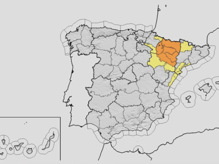
The storms will once again take center stage this Saturday in the Ebro valley, with a risk of sudden floods in various points of Aragón, Navarra, and Catalonia. The Ebro Hydrographic Confederation (CHE) has warned of the possibility of rapid increases in flow rates, while the AEMET has active weather warnings for rain, storms, hail, and strong gusts of wind.

The situation is particularly concentrated during the afternoon, so emergency services are urging extreme caution in areas near rivers, ravines, and waterways, especially given the possibility of intense precipitation in a short time.

Where is there a risk of floods?

The CHE is monitoring various points of the basin due to the possibility of sudden floods associated with the storms.

The risk mainly affects areas of Aragón, Navarra, and Catalonia, with special attention to the evolution of the waterways and tributaries of the Ebro.

Episodes of intense rain can cause rapid increases in water levels, even if the precipitation is not recorded directly at the affected point.

Weather warnings for this afternoon

The AEMET maintains warnings for phenomena associated with storms in various areas of the northeastern peninsula. Among the expected risks are intense rains, hail, and strong gusts of wind.

The situation can change rapidly throughout the afternoon, so it is recommended to check the update of the weather warnings before traveling.

Huesca, Zaragoza, Teruel, and Lleida, among the areas to monitor

Within the environment of the Ebro valley, the evolution of the storms requires special attention to Huesca, Zaragoza, Teruel, and Lleida, as well as various points in Navarra.

The combination of intense storms and rapid accumulation of water can generate problems on roads, underpasses, areas near waterways, and urban areas.

What to do in the event of a sudden flood

In the event of an intense storm, authorities recommend avoiding approaching rivers, ravines, and flood-prone areas and not attempting to cross a water-covered area with a vehicle.

The risk can appear in a matter of minutes, so the weather forecast and the evolution of the waterways will be key during the next few hours.

The situation will remain under surveillance this afternoon in the Ebro valley, with special attention to Aragón, Navarra, and Catalonia. To know the evolution of the warnings, it is advisable to consult the updates from AEMET and the CHE.

More key points, information and questions with FREN

AI-GENERATED CONTENT

What procedures do AEMET and the Ebro Hydrographic Confederation follow to declare and update meteorological storm warnings?

The management of storm warnings in Spain relies on two distinct but connected components: the meteorological warnings from AEMET and the hydrological warnings/monitoring from the hydrographic confederations, including the Ebro Hydrographic Confederation (CHE). Each organization has its own procedures and coordinates through regional emergency centers and, in major events, through CECOPI.

1. How AEMET issues storm warnings

According to the AEMET delegate in Cantabria, the agency works with a network of meteorological stations, radiosonde balloons, radars and satellites, whose data feed numerical prediction models that are continuously recalculated (interview on eldiario.es). From these models, forecasts are made and, when potentially adverse phenomena are expected (heavy rain, storms, hail, strong winds…), the scope of the Meteoalert Plan is entered.

The Meteoalert system establishes specific thresholds by area, which take into account not only the physical intensity of the phenomenon but also the vulnerability of the area and how “accustomed” the population is to certain values. The delegate himself explains that the threshold for issuing frost or snow warnings is not the same on the coast as in very cold inland areas, and that the peninsula is divided into climatically homogeneous areas to adjust these thresholds.

With these criteria, AEMET issues warnings at three main levels (recorded, for example, in the BOE and in outreach guides):

  • Yellow: low but real risk, relevant for sensitive activities or vulnerable groups.
  • Orange: significant risk, with a high probability of relevant incidents affecting mobility, property, and people.
  • Red: extreme risk, reserved for situations of very serious and widespread danger.

The warnings indicate the phenomenon (storms, heavy rain, etc.), the affected area, the time interval, and often the probability that the event will materialize. They are disseminated through the official warning map on AEMET’s website and app, as well as social networks and specific emergency channels.

In episodes of special impact, AEMET may issue a special warning and, in the case of very adverse DANAs or storms, assign them a proper name, precisely to improve communication and preparation of administrations and the public (MITECO note).

Updating the warnings

AEMET itself and various regional bulletins emphasize that warnings are dynamic: they can be activated, expanded, downgraded, or deactivated as the atmosphere evolves. Therefore, it is stressed to consult “real-time” information throughout the day, especially in convective storm situations where the exact location can change with only a few hours’ notice.

2. What the Ebro Hydrographic Confederation does

CHE does not issue meteorological warnings but rather hydrological information and warnings related to rises and floods. Its role is well reflected in several Civil Protection notes from Catalonia, which indicate that, in episodes of heavy rain, CHE:

  • Activates intensified monitoring” due to the adverse weather forecast.
  • “Reminds of the possibility of significant sudden rises locally in ravines and streams” in the most affected areas (INUNCAT, 31/08/2025).
  • Maintains “monitoring of small rivers and ravines” in specific areas of the Segre basin and its tributaries, in coordination with the Catalan emergency center (INUNCAT, 23/07/2025).

Other communications note that CHE, in episodes forecast by AEMET, warns of significant rises in ravines in the Pyrenees, Lleida, Castellón, and Teruel (report in El Mundo). This hydrological information is based on its gauging and flow control networks and serves as a reference for regional flood plans.

A note from the Generalitat Valenciana about the 2024 DANA also recalls that the communication of hydrological warnings regarding possible floods corresponds to basin organizations, and that these warnings are channeled through regional emergency coordination centers to State Civil Protection (Comunitat Valenciana, 04/11/2024).

3. Coordination between AEMET, CHE, and emergency centers

Coordination is structured at several levels:

  • Regional centers (such as the Valencian 112) maintain permanent contact with AEMET’s forecasting service to adjust their pre-emergency phases, and simultaneously continuous communication with the confederations of Júcar, Segura, and Ebro “to inform and monitor flows” (flood prevention campaign, GVA).
  • In major emergencies, the CECOPI is established, where AEMET provides warnings and data “updated, validated, and transmitted directly” considered priority information for decision-making, while the confederations provide the status of rivers and reservoirs.
  • Based on this, communities activate their flood plans (INUNCAT, PERI, INUNCAM, etc.) and, if appropriate, Civil Protection may activate population alert systems (such as ES-Alert), which are different and subsequent to AEMET’s technical warnings and CHE’s hydrological warnings.

In summary, AEMET decides when and how to warn about the storm (level and area), while CHE decides how to monitor and communicate rises resulting from that storm in the Ebro basin. Both flows converge in emergency centers, which transform that information into operational civil protection decisions.

Can you detail what thresholds AEMET uses to move from yellow to orange or red warnings specifically in the Ebro valley? What role do regional flood plans (INUNCAT, INUNCAM, PERI, etc.) play based on warnings from AEMET and CHE? Have there been recent changes in the procedures of the Ebro Hydrographic Confederation following events like the Biescas flood or the 2024 DANA?

What are the competencies of the Ebro Hydrographic Confederation in managing rises and hydraulic alerts?

The Ebro Hydrographic Confederation (CHE) is the state basin authority responsible for the public hydraulic domain throughout the Ebro demarcation. Regarding rises, floods, inundations, and hydraulic alerts, its competencies are mainly based on the Consolidated Water Law (Royal Legislative Decree 1/2001) and on Royal Decree 903/2010, on flood risk assessment and management, as well as on specific hydrological and flood risk management plans for the Ebro.

1. Basic competencies as a basin authority

The article concerning basin authorities in the Water Law assigns to confederations, and thus to CHE, among others, the following functions directly related to rises and floods:

  • Granting authorizations and concessions related to the public hydraulic domain (rivers, channels, banks, and servitude and police zones), as well as monitoring compliance. This includes authorizing or reporting on works, defenses, and occupations in flood-prone areas.
  • Conducting gauging, hydrological studies, and providing information on rises, and exercising water quality control. The Water Law explicitly mentions “information on rises” as a task of basin authorities.
  • Studying, designing, executing, maintaining, operating, and improving hydraulic works under its competence (dams, channeling, defenses, river restorations, etc.), including those aimed at attenuating floods and reducing flood risk.
  • Defining quality objectives and programs associated with hydrological planning, relevant when floods carry sediments or contaminants.
  • Developing plans, programs, and actions for proper management of water demands and uses, which conditions reservoir operation during rise episodes.
  • Advising the General State Administration, autonomous communities, local entities, and individuals on matters related to water and the public hydraulic domain.

2. Flood risk management and planning

Royal Decree 903/2010 implements the European Floods Directive and assigns a central role to basin authorities in risk management:

  • Preliminary flood risk assessment in the Ebro demarcation, identifying areas with significant potential risk.
  • Preparation of hazard maps (extent and depths for different return periods, including extreme floods) and risk maps (affected population, economic activities, infrastructures, protected areas).
  • Drafting Flood Risk Management Plans (PGRI) for the Spanish part of the Ebro demarcation, with programs of measures including structural works, river restoration, and non-structural measures (use restrictions in flood zones, improved information, etc.).
  • Coordination with general hydrological planning: Ebro hydrological plans must incorporate criteria and actions to prevent and mitigate flood and rise damage.
  • Relation to land use planning: the royal decree establishes that urban planning and land use instruments must be compatible with flood risk management plans and sectoral regulations, which in practice makes CHE a key actor through its reports on planning and projects in flood-prone areas.

3. Automatic Hydrological Information Systems (SAIH) and alerts

Although state regulations do not detail basin by basin, practice and regional plans clearly show the role of confederations in Automatic Hydrological Information Systems (SAIH) and alerts:

  • Basin authorities are responsible for the operation of SAIH networks, which record precipitation, levels, and flows in real time and form the basis of the “information on rises” referred to in the Water Law.
  • In the Special Flood Plan of the Valencian Community, for example, specific functions are assigned to the Júcar Hydrographic Confederation:
    • Providing real-time SAIH data to the regional emergency center when pre-emergency is declared, especially when certain precipitation thresholds are exceeded.
    • Generating automatic warnings to civil protection upon exceeding rainfall or flow thresholds measured by the SAIH network.
    This scheme illustrates the general model applicable to CHE in its demarcation: the confederation measures, analyzes, and warns emergency services, which declare emergency phases and communicate to the population.
  • Official notes about the Rialb dam (Catalonia) show how CHE informs Civil Protection, participates in technical committees of the INUNCAT plan, and holds monitoring meetings during risk episodes, reflecting its technical and coordination role.
  • At the state level, initiatives like the GOTA portal, which integrates information from confederations, AEMET, and European flood alert systems, are fed by data generated by these organizations, including CHE, to anticipate floods.

4. What CHE does not do regarding alerts

It is important to distinguish competencies:

  • CHE does not perform civil protection functions in the strict sense: it does not declare emergency levels, order evacuations, or send mass messages to the population. That responsibility lies with the autonomous communities (INUNCAT, INUNCYL plans, etc.) and, if applicable, the State through national civil protection plans.
  • Its role is essentially technical and related to managing the public hydraulic domain: operating dams and channels safely, measuring and communicating hydrological status, designing defenses, restoring rivers, and issuing hydrological reports and information that serve as a basis for civil protection decisions.

In summary, the Ebro Hydrographic Confederation is the technical authority over rivers and reservoirs in its demarcation: it plans and executes defense works, monitors rises and flows in real time through SAIH, generates hydrological information and warnings to civil protection, and conditions the occupation of flood-prone areas. However, the decision to activate alerts to the public and manage emergencies corresponds to state and regional civil protection systems.

What legal requirements must municipalities meet to activate emergency plans for floods in Aragón, Navarra, and Catalonia?

The legal requirements for a municipality to activate emergency plans against floods are based first on the state framework for civil protection and flood risk management, and then on the specific regional regulations of Aragón, Navarra, and Catalonia, which specify municipal obligations.

1. Common state framework

At the state level, the Law 17/2015, of July 9, on the National Civil Protection System (text in BOE) and the Basic Civil Protection Standard, approved by Royal Decree 524/2023, of June 20 (RD 524/2023), establish:

  • The existence of territorial plans and special plans for specific risks (including floods), within which local plans are integrated.
  • A minimum content for plans: risk analysis, command organization, coordination centers, action groups, phases and operational situations (0, 1, 2, and 3), and population information procedures.
  • The need for local plans to be coordinated and integrated into regional plans and, if applicable, the State Plan.

For flood risk, Royal Decree 903/2010, of July 9, on flood risk assessment and management (RD 903/2010) and the State Civil Protection Plan for Flood Risk, approved by Resolution of August 2, 2011 (State Plan), require:

  • That different administrations, including local ones, participate in risk assessment and in the preparation of flood hazard and risk maps.
  • That civil protection plans are based on this information and establish inter-administrative cooperation mechanisms.

Consequently, any municipality wishing to activate an emergency plan for floods must:

  • Have a municipal civil protection or municipal action plan when required by regional regulations or the special flood plan.
  • Have a risk map and catalog identifying flood-prone areas and vulnerable elements.
  • Define in the plan activation phases and thresholds, competent authority (usually the Mayor) and mechanisms to notify 112 and the autonomous community.
  • Provide procedures for population information and self-protection, as well as drills and exercises.

2. Aragón

Law 4/2024, of June 28, on the Civil Protection and Emergency Management System of Aragón (Law 4/2024) and the Special Civil Protection Plan for Flood Risk in Aragón (PROCINAR), approved by Decree 201/2019 (PROCINAR), specify that:

  • Local entities are part of Aragón’s civil protection system and must develop and approve civil protection plans (articles of Law 4/2024 on local entities and municipalities).
  • Municipalities with > 20,000 inhabitants must:
    • Create the municipal civil protection structure.
    • Develop and approve the Municipal Territorial Plan for civil protection, which must integrate flood risk and coordinate with PLATEAR and PROCINAR.
    • Have a risk catalog and map and means and resources.
    • Implement plans (information campaigns, drills) and establish, when appropriate, the Cecopal (municipal coordination center).
  • Municipalities with < 20,000 inhabitants must at least maintain a risk catalog and map and integrate into the comarcal plan; some may develop their own plan if risks warrant it.
  • The mayor is the highest municipal civil protection authority, responsible for:
    • Declaring the emergency and activating the municipal plan in case of floods.
    • Immediately notifying the 112 Aragón Emergency Center and coordinating with the autonomous community.

3. Navarra

Foral Law 8/2005, of July 1, on civil protection and emergency care in Navarra (Foral Law 8/2005), amended by Foral Laws 8/2019 and 8/2023, and the Special Civil Protection Plan for Flood Risk of the Foral Community (Agreement of March 28, 2011; special flood plan), establish:

  • Obligation to develop and approve a municipal civil protection plan for:
    • Municipalities with population > 20,000 inhabitants.
    • Municipalities included in the Navarra Risk Catalog and Map due to their geographic location or activity (industrial, touristic, etc.).
  • Municipal and supra-municipal plans are approved by the local entity plenary and must be endorsed by Navarra’s Civil Protection Commission, which verifies their adequacy to the Territorial Plan.
  • Special plans (such as flood plans) may designate municipalities required to have specific municipal action plans against that risk.
  • Foral Law 8/2005 states that plans must be permanently updated and that the Mayor is the highest municipal civil protection authority, with the power to:
    • Activate and deactivate the Municipal Territorial Plan.
    • Request resources and activation of higher-level plans.
  • There is an Alarm and Alert Network that defines adversity thresholds and involves issuing warnings to local entities; services and entities linked to emergencies must notify the Emergency Management Center of any situation that could lead to a civil protection emergency.

4. Catalonia

In Catalonia, without entering into unlisted regulations, the framework is given by:

  • The cited basic state legislation (Law 17/2015, Basic Standard, and RD 903/2010).
  • Flood risk management plans for Catalonia’s river basin, such as the one approved by Royal Decree 688/2023, of July 18 (flood risk management plan), developed in collaboration with civil protection authorities.
  • The corresponding territorial civil protection plan and regional special flood plan, which, according to the Basic Standard, establish:
    • Which municipalities must have a municipal action plan against floods.
    • The integration of those municipal plans into the regional planning structure.
    • Activation criteria (phases and situations), the competent municipal authority (usually the Mayor), and procedures for coordination with 112 and the Generalitat, as well as population warning.

In summary, in the three communities, municipalities need to: have a municipal plan or be integrated into a supra-municipal plan when required by basic law and regional regulations, base it on flood risk analysis, define a clear chain of command and coordination with the autonomous community and the State, and comply with notification and information obligations to the population when activating their emergency plans.

Play

Test your knowledge with FREN!

How much do you know about this topic? Answer the following 3 questions.

Which organizations have issued warnings about the risk of storms and floods in the Ebro valley?

Question 1 of 3

Which are some of the provinces mentioned as areas to watch for flood risk?

Question 2 of 3

What recommendation do authorities make in the event of a sudden flood during intense storms?

Question 3 of 3

Hola, soy Fren. ¿Cómo te ayudo?