Earthquakes in Granada: after more than 350 earthquakes, what can seismology predict?

The earthquakes in Granada have exceeded 350 movements since August 14, and the ground shook again this Tuesday with a magnitude 4.8 earthquake. Seismology allows us to analyze how this sequence evolves, but can it anticipate if another earthquake will occur, when it will happen, or what magnitude it will reach?

4 minutes

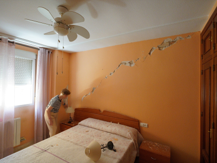
EuropaPress 7719644 imagenes destrozos causado terremoto 18 agosto 2026 granada andalucia

EuropaPress 7719644 imagenes destrozos causado terremoto 18 agosto 2026 granada andalucia

Add DEMÓCRATA to Google

Ask FREN

Published

Last updated

4 minutes

Most read

Seismology can confirm that Granada is undergoing an active sequence, analyze how it evolves, and calculate general probabilities. What it cannot do is accurately anticipate whether there will be another earthquake, when it will occur, or what magnitude it will have.

Granada has once again suffered a tremor of magnitude 4.8, with an epicenter northwest of Gójar and a very shallow depth. The earthquake occurred at 10:37 a.m. and was followed by several movements in the metropolitan area, including tremors of magnitudes 3.9, 4.2, and 4.0, according to provisional data from the National Geographic Institute (IGN).

The episode comes four days after the moment magnitude 4.8 earthquake recorded at 23:04 UTC on August 14 -1:04 a.m. on Saturday, August 15, in mainland Spain-, with an epicenter northeast of Alhendín. Two earthquakes of similar size, separated by a few days and located in the same area, confirm that seismic activity continues. However, they do not allow for anticipating what the next movement will be.

More than 350 movements since August 14

The latest technical note from the IGN, updated before the earthquakes this Tuesday, counted 348 events in the series since 00:00 hours on August 14. The majority had magnitudes below 2 and all occurred at less than ten kilometers deep. A total of 37 had been felt by the population.

By adding the new movements incorporated this Tuesday into the seismic catalog of the IGN, the sequence exceeds 350 events. Not all should be automatically classified as aftershocks: the technical term depends on the spatial and temporal relationship between the tremors and which one ends up being identified as the largest earthquake in the series.

Until this Tuesday, the IGN considered the movement of Alhendín as the main one and placed its largest aftershock at magnitude 3.3. The appearance of another earthquake of 4.8 forces a review of the evolution of the sequence, but does not turn the new tremor into a precursor of a larger one.

Can a larger earthquake occur in Granada?

The National Geographic Institute explains that there is currently no method capable of simultaneously predicting the moment, place, and magnitude of an earthquake. The succession of movements confirms that the area remains active and that more tremors may be recorded, but it does not contain an unequivocal signal that a more powerful earthquake is approaching.

The majority of seismic sequences evolve with subsequent smaller earthquakes and with a frequency that tends to decrease over time. That statistical pattern also does not work as a guarantee: there can be days with spikes in activity or with clearly perceptible aftershocks before the series loses strength.

As a global reference, the United States Geological Survey estimates that around 5% of earthquakes are followed in the following week by another larger and nearby one. That percentage is a global average, not a specific forecast for Granada, so it should not be directly applied to the sequence of Alhendín and Gójar.

Does the previous earthquake now become a precursor?

Seismologists refer to a precursor as an earthquake that precedes another larger one in the same area. The problem is that no movement can be identified as a precursor in real time: it only receives that name if another of greater magnitude occurs afterwards.

If the next earthquake is smaller, it is normally integrated among the aftershocks. If a larger one appears, it retrospectively changes the classification of the previous ones. That is why the repetition of tremors does not constitute a prediction by itself.

The two main earthquakes known so far have a moment magnitude of 4.8. Talking about a "seismic doublet" would require studying in detail their location, depth, rupture mechanism, and relationship with the surrounding faults. The similarity of magnitudes and geographical proximity is not enough to establish it automatically.

Why they are being felt so strongly

The perception of the earthquakes in Granada is related to their shallow depth and the proximity of the epicenters to densely populated municipalities in the metropolitan area.

A shallow earthquake can cause an intense shaking near the epicenter even if its magnitude is moderate. The magnitude measures the energy released; intensity describes how it feels and what effects it produces in each place. They are distinct concepts.

The Alhendín earthquake was felt in more than 500 localities and reached a maximum intensity of V-VI on the European macroseismic scale. The IGN received more than 12,000 citizen questionnaires and confirmed non-structural damage and falls of objects in the epicentral area.

The most likely now: more movements, but not necessarily larger

The scientific conclusion is not that a larger earthquake is going to occur, but neither that the sequence has ended. It is reasonable to expect new movements while the activity readjusts, most of them of low magnitude and possibly imperceptible.

The immediate risk does not solely depend on the occurrence of a larger earthquake. A moderate aftershock can cause new detachments in facades, cornices, or previously damaged buildings. Hence, the authorities maintain vigilance and ask to avoid the marked areas, not to stay next to deteriorated elements, and to follow only the information from the IGN and emergency services.

More key points, information and questions with FREN

AI-GENERATED CONTENT

What is the review and update process of the seismic catalog of the National Geographic Institute?

The National Geographic Institute (IGN), through the National Seismic Network, maintains a seismic catalog that is continuously updated and subject to permanent review. There is no "fixed frequency" of updates (daily, weekly, etc.), but rather a chain process that goes from the automatic detection of an event to the publication of a revised record whose parameters may change as new data are incorporated.

1. Initial detection and recording of earthquakes

The starting point is the stations of the National Seismic Network, distributed throughout the territory, which record ground vibrations 24 hours a day. When several stations detect signals compatible with an earthquake, the system identifies a possible event and generates a first location and magnitude.

Various journalistic reports cited by the IGN itself emphasize this continuous recording nature. For example, regarding the Granada seismic series, it is explained that the IGN list "is updated as stations detect and review new events" and that the catalog "continues to incorporate new movements" as the aftershock sequence progresses (Demócrata).

2. Publication of preliminary data in the catalog

Once the event is detected, the IGN publishes a preliminary record in its seismic catalog and in its recent activity lists. This record includes, among other elements:

  • Origin time of the earthquake.
  • Approximate epicentral location.
  • Initial estimated depth.
  • Magnitude (in the scale used in each case).
  • Basic information about the affected area and perceived intensity if available.

In the news coverage of the Alhendín (Granada) earthquake, this process is seen: first, an event of magnitude 5 with a depth of about two kilometers was reported, and hours later, the "latest available IGN record" already reflected changes in depth and other parameters, making it clear that "all these parameters are subject to modifications as seismic analysis continues" (Demócrata).

3. Review and refinement of parameters

The central aspect of the review process is that the catalog is not static. The IGN repeatedly indicates that:

  • Recent information "is subject to continuous review," so location, depth, and magnitude may vary as more network records are incorporated and more detailed analyses are applied ( Demócrata ).
  • In significant episodes, such as Granada, subsequent magnitude revisions are published: the same earthquake was initially reported as magnitude 5 and later appeared in the updated catalog with magnitude Mw 4.8, illustrating the progressive refinement of the calculation ( Demócrata ).

This type of revision is also common in other seismological organizations cited in the press (for example, the United States Geological Survey or national services of other countries), and journalistic coverage treats it as normal that magnitudes and depths are "revised up or down" after the first bulletin.

4. Data sources and validation

Although the articles do not describe each IGN internal algorithm in technical detail, they do allow identification of several sources and validation criteria:

  • IGN National Seismic Network: the main source, providing instrumental records from which magnitude, location, and intensity are calculated ( Demócrata ).
  • Collaboration with other geoscientific organizations: for example, cooperation between the Geological and Mining Institute of Spain and the IGN "analyzing seismic series minute by minute" in Cádiz and Málaga ( Demócrata ), which strengthens joint validation of data interpretation.
  • Contrast with macroseismic observation: the press frequently reports that the IGN also assigns intensities based on how the earthquake was felt in each area. These data come both from the instrumental network and from information received through emergency services and field observations.

5. Result: a dynamic and officially referential catalog

The result of this process is a catalog that:

  • Is fed in near real-time by the network of stations, adding each new event as soon as it is identified.
  • Continuously refines the records already published, with explicit changes in magnitude, depth, and other parameters when analysis justifies it, as seen in the case of Granada.
  • Integrates technical validation (instrumental analysis) and collaboration with other specialized organizations to interpret seismic series and discard unlikely causes.
  • Acts as an official reference for administrations, emergency services, and media when describing what happened, where, and with what intensity.

In summary, rather than a periodic exercise of "batch updating," the IGN seismic catalog is a living system, updated event by event and maintaining information under constant review to offer, at every moment, the best available estimate of seismic activity in Spain and its surroundings.

What are the competencies of the National Geographic Institute in seismic emergency management?

The National Geographic Institute (IGN) is the State's reference body in seismic monitoring and, therefore, a key actor in earthquake emergency management in Spain. Its competencies are supported by civil protection regulations, the national cartographic system, and specific geophysical monitoring agreements, and are specified both in the prevention phase and in the immediate response to earthquakes.

Seismic monitoring and generation of official information

The State Civil Protection Plan against Seismic Risk, approved by Council of Ministers Agreement and published by Resolution of March 29, 2010 (BOE-A-2010-5661), establishes a Seismic Information System whose core is the National Seismic Network, dependent on the IGN. This Plan assigns the Institute the functions of:

  • Planning and management of detection and communication systems for seismic movements in national territory and adjacent areas, including the National Seismic Network.
  • Observation and calculation of seismic parameters (location, magnitude, depth, affected area, intensity estimation) for all earthquakes that may impact the population.
  • Issuance of the so-called "Seismic Alert": rapid communication of parameters of any relevant earthquake (from magnitude 3 or felt by the population) to the bodies of the National Civil Protection System.
  • Continuous updating of the national seismic catalog, reviewing parameters as new records from the National Seismic Network are incorporated, as reflected in multiple notes consulted and recent emergency coverage in Granada.

In practice, both in regulations and recent public information, the IGN and its National Seismic Network are considered the official reference to determine where an earthquake occurs, its magnitude, depth, and characteristics, as well as to maintain the seismicity and seismic hazard maps of Spanish territory.

Relationship with Civil Protection and operational emergency management

The State Seismic Risk Plan expressly places IGN information at the service of civil protection authorities:

  • The objective of the Seismic Information System is to provide, with maximum speed and reliability, data that serve as a basis for the authorities of the National Civil Protection System to decide on the activation of emergency plans and protection measures for the population.
  • The IGN must communicate seismic information to the Directorate General of Civil Protection and Emergencies through usual procedures and those specifically enabled for emergencies.
  • In coordination with that Directorate General, the IGN must develop:
    • Intensity or ground motion cartography in the affected area.
    • Lists or cartography of damage by population entities, based on instrumental data and macroseismic questionnaires.
    • Periodic information on aftershocks, adjusting frequency according to activity.
  • The State Plan considers "concerned organizations" all state services that perform functions of forecasting, prevention, monitoring, and information on seismic phenomena, including the IGN, integrating them into the response organization.

Additionally, Spain has articulated a National Tsunami Warning System, in which the National Seismic Network, dependent on the IGN, acts as the body responsible for detecting, assessing, and initially informing about seismic phenomena capable of generating tsunamis, as reflected, for example, in the agreement published in the BOE on sea level monitoring in the Balearic Islands (BOE-A-2025-22841).

Cartography, risk analysis, and technical support

Although Law 17/2015 of the National Civil Protection System does not detail specific seismic functions of the IGN, cartographic regulations and civil protection plans complete its role:

  • Royal Decree 1545/2007, which regulates the National Cartographic System (BOE-A-2007-20556), entrusts the Directorate General of the IGN with the formation, control, and dissemination of the National Reference Geographic Equipment, the basis of official cartography on which thematic maps, including seismic hazard and risk maps, are developed.
  • The State Civil Protection Strategy and Plans cite risk analyses and their zoning, with hazard, vulnerability, and risk cartography as mandatory components of planning; these products rely on geographic and seismic information generated or coordinated by the IGN.
  • Recent documents from the Institute itself, referenced in the BOE, highlight among their strategic objectives the use of advanced instrumentation to provide seismic and volcanic monitoring and alert services, integrating geodetic, geophysical, and cartographic observations.

Strategic planning and scientific cooperation

Finally, the IGN plays a role in design and coordination of geophysical monitoring at the national scale. The National Plan for Seismic, Volcanological, and Other Geophysical Phenomena Monitoring, approved by the Council of Ministers in 2025 and developed by the Institute, articulates 58 measures to strengthen monitoring networks, improve early warning systems, and coordinate administrations and scientific centers (Ministry of Transport note).

Overall, its competencies in seismic emergencies range from earthquake detection and technical analysis, through issuance of alerts and intensity cartography, to continuous advice to Civil Protection and provision of the geographic and knowledge base necessary to plan and manage seismic risk in Spain.

What are the legal requirements for declaring a disaster area after an earthquake in Spain?

In Spain, the former "disaster area" is now technically called a "zone seriously affected by a civil protection emergency". Its basic regulation is in the Law 17/2015, of July 9, on the National Civil Protection System (text in BOE) and, for economic aid, in Royal Decree 307/2005, of March 18, modified by RD 477/2007 (text in BOE). The requirements are not designed solely for earthquakes, but a seismic event fully fits the type of disaster contemplated.

1. Nature of the figure and regulatory framework

Law 17/2015 foresees this declaration as an instrument to activate a set of exceptional repair and support measures once the emergency phase has been managed. It is not essential to have a declaration for aid to exist, but it is the ordinary way to deploy a broad package of subsidies, fiscal, labor, and Social Security measures.

For specific phenomena (earthquakes, floods, etc.), special civil protection plans are developed (art. 17 of the law), which serve as a technical reference to assess the severity of damages and the necessary response.

2. Who declares the affected zone?

According to Law 17/2015 (articles in the chapter on recovery and aid):

  • The declaration is made by agreement of the Council of Ministers.
  • The proposal corresponds, at least, to the Ministers of Finance and Interior, and if applicable to other affected ministries (for example, Transport, Agriculture, etc.).
  • The ultimate competence to "declare a zone seriously affected by a civil protection emergency" is expressly attributed to the Government of the Nation.

3. Who can request the declaration?

The law establishes that the declaration "may be requested by the interested public administrations". In practice, this typically includes:

  • Autonomous communities affected by the earthquake.
  • Local entities (municipalities, provincial councils, island councils) of the damaged area.
  • Other bodies of the General State Administration with competencies in the territory.

Before deciding, the Government may request a report from the affected autonomous community or communities, in order to have a technical and economic assessment of the damages.

4. Material criteria for the declaration

Law 17/2015 sets general criteria, applicable to any disaster (including an earthquake). To declare a zone as seriously affected by a civil protection emergency, it is assessed, "in any case," that:

  • Personal or material damages have occurred as a result of a disaster (for example, an earthquake), and
  • That these damages:
    • seriously disrupt the living conditions of the population in a determined geographic area, or
    • cause the total or partial paralysis of essential public services (water supply, energy, transport, communications, health care, etc.).

The law does not set rigid numerical thresholds (number of victims, percentage of damaged homes, etc.). The assessment is technical-political, case by case, based on damage reports and civil protection evaluation.

5. Relationship with economic aid and other measures

Once the zone is declared, the law allows the Council of Ministers to approve a list of specific measures, among others:

  • Economic aid to individuals for damages to main residence and essential belongings.
  • Compensation to local corporations for expenses of urgent emergency actions.
  • Aid to individuals or legal entities that have provided services or goods at the request of the competent authority.
  • Aid to industrial, commercial, and service establishments affected.
  • Subsidies for municipal infrastructures and provincial or island road networks.
  • Aid for damages to agricultural, livestock, forestry, or aquaculture productions.

These measures are articulated with emergency subsidy regulations, mainly Royal Decree 307/2005 and its modification by Royal Decree 477/2007, which regulate:

  • What is understood by "emergency or catastrophic nature situation".
  • The possible beneficiaries (family units, local corporations, small businesses, homeowners' associations, etc.).
  • The direct granting procedure of aid and its compatibility with insurance and compensations.

Additionally, the second final provision of Law 17/2015 enables the adoption of labor and Social Security measures (force majeure temporary layoffs, contribution moratoriums, etc.), which are developed through specific ministerial orders for each episode.

6. Summary applied to an earthquake

After an earthquake, therefore, the declaration of a zone seriously affected by a civil protection emergency requires, in summary:

  • That the seismic event causes significant personal and/or material damages, with serious disruption of daily life or paralysis of essential services.
  • That the affected public administrations request the declaration and provide damage reports.
  • That the Council of Ministers, at the proposal of Interior and Finance, appreciates this severity and formally approves the declaration, delimiting the territorial scope and incorporating the catalog of extraordinary aids and measures to be applied.
What specific types of economic, fiscal, and labor aid have been approved in other earthquake declarations in Spain, and how might they compare with those for other natural disasters? What role do autonomous communities and municipalities play in damage assessment and in requesting the declaration of a zone seriously affected by a civil protection emergency? How is the action of the Insurance Compensation Consortium coordinated with public subsidies after an earthquake declared as a civil protection emergency?

Play

Test your knowledge with FREN!

How much do you know about this topic? Answer the following 3 questions.

What was the magnitude of the main earthquake recorded this Tuesday northwest of Gójar?

Question 1 of 3

What global percentage of earthquakes is followed by a larger and nearby one during the following week, according to the United States Geological Survey?

Question 2 of 3

What is the difference between magnitude and intensity in earthquakes according to the news?

Question 3 of 3

Hola, soy Fren. ¿Cómo te ayudo?