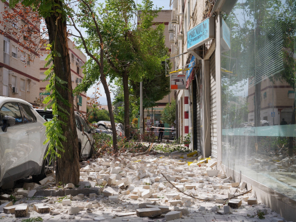
Granada trembles again during the night: six new earthquakes shake the province

The IGN registered six movements since midnight on Wednesday, five of them felt by the population, after the earthquake of magnitude 3.4 that closed the day on Tuesday in Ogíjares.

2 minutes

terremotos Granada

terremotos Granada

Add DEMÓCRATA to Google

Ask FREN

Published

Last updated

2 minutes

Most read

The seismic activity did not give a break to Granada during the night. After the earthquake of magnitude 3.4 recorded at 10:35 PM on Tuesday in Ogíjares, the National Geographic Institute (IGN) counted six new earthquakes since midnight, five of them felt by the population.

The new sequence adds to several days of intense activity in the metropolitan area of Granada, where the IGN continues to record movements after the two strong earthquakes of recent days, the one of magnitude 5 from last Saturday and the one of 4.8 recorded on Tuesday.

Six earthquakes since midnight

The six movements recorded during the early morning and the first hours of Wednesday had different intensity and were located in the vicinity of the metropolitan area of Granada. Five were felt by the neighbors, according to data collected from the IGN records.

The largest of these new earthquakes reached a magnitude of 2.58, below the earthquake of magnitude 3.4 that had occurred a few hours earlier in Ogíjares and that closed the day on Tuesday.

Another night of activity after the strong earthquakes

The early morning occurs after a particularly intense day. On Tuesday, Granada and its metropolitan area recorded an earthquake of magnitude 4.8, widely felt by the population, followed by several movements of lesser intensity in nearby municipalities.

That sequence once again placed the seismic activity of Granada in the spotlight just a few days after the earthquake of magnitude 5 recorded during the early morning of Saturday, which had its epicenter in the vicinity of Alhendín.

Since then, the IGN has continued to record movements in different points of the metropolitan area. The activity of the last night confirms that the sequence remains active, although the six earthquakes counted since midnight were of a clearly lower magnitude than the main earthquakes recorded in recent days.

The IGN keeps the seismic sequence under monitoring

The data of the earthquakes are subject to technical review by the National Geographic Institute, so the magnitudes, locations, and depths may be updated as the records of the National Seismic Network are analyzed.

Granada is one of the areas in Spain with the highest seismic activity. The province is located in an area affected by the convergence between the African and Eurasian plates, a process that generates tensions in various faults in the south and southeast of the Peninsula.

The seismic activity in Granada will therefore continue to be monitored after a night in which the IGN recorded six earthquakes since midnight, five of them felt by the population.

More key points, information and questions with FREN

AI-GENERATED CONTENT

What procedures does the National Geographic Institute follow for updating and validating seismic data after an earthquake?

After an earthquake in Spain, the National Geographic Institute (IGN), through the National Seismic Network, follows a continuous procedure of detection, validation, and updating of seismic data that then serve as a basis for Civil Protection and other administrations. It is a technical, iterative, and largely automated process, but always supervised by seismologists.

1. Initial detection and recording of the earthquake

  • Network of seismic stations: the IGN maintains dozens of stations distributed throughout the territory. In active areas, such as the surroundings of Granada, the network is especially dense and is reinforced with portable stations during a seismic crisis, as explained in the analyses of the Granada series published by Demócrata and by the Ministry of Transport itself.
  • Automatic recording: when an earthquake occurs, signals are captured almost in real time. Detection algorithms locate an event and generate a first “automatic solution”: time, approximate epicenter, preliminary magnitude, and depth.
  • Immediate provisional publication: this first solution is uploaded to the “latest earthquakes” section and the IGN Earthquakes viewer. This information is expressly considered provisional and the IGN itself warns that “it may be modified during the seismic analysis review,” as recent pieces about the Granada earthquakes in Demócrata show.

2. Validation and technical review of parameters

  • Review by the National Seismic Network: signals received at different stations are reanalyzed to adjust the location and depth. As more observations are incorporated and models refined, the following are recalculated:
    • the coordinates of the epicenter;
    • the depth (an initial value of “0 km” may change after review);
    • the magnitude (for example, an event initially published as 4.2 was later revised to 4.3 in the Granada sequence);
    • and even the reference locality used to describe the epicenter.
  • Continuous catalog correction: the official earthquake catalog of the IGN “is continuously updated as new data arrive,” as highlighted in several reports about Granada. That is, the record of the same earthquake can change several times in the first hours.
  • Supervision by seismologists: although the first calculations are automatic, the review is carried out by specialized personnel who decide if the solution is consistent with the set of records, the pattern of the series, and the geological knowledge of the area.

3. Incorporation of macroseismic information

  • In addition to instrumental data, the IGN collects the so-called macroseismic intensity, that is, how the earthquake was felt and what effects it had.
  • For this, it offers a macroseismic questionnaire on its website and app. Citizens indicate where they were, what they noticed, if objects fell or visible damage occurred, etc. Demócrata reports that tens of thousands of questionnaires have already been received during the Granada crisis.
  • These responses allow:
    • delimiting the localities where the earthquake was felt;
    • assigning an intensity to each municipality and a maximum global intensity (for example, V–VI);
    • and complementing the risk assessment managed by Civil Protection and local authorities.

4. Dissemination of data to the public and administrations

  • Public platforms: the reviewed information is disseminated through:
    • the official IGN earthquake catalog;
    • the “latest earthquakes” map viewer with interactive maps;
    • and applications such as IGN Earthquakes, highlighted on the electronic Administration portal.
  • Technical notes and reports: in relevant sequences, the IGN publishes technical notes summarizing the evolution of the series (number of events, magnitudes, average depth, etc.) and its scientific interpretation.
  • Repeated updating: media that reuse these data (charts, maps in the press, etc.) are forced to update their tables as the IGN revises magnitudes and depths; Demócrata explicitly notes that their lists “must be updated when the agency revises the data or records new aftershocks.”

5. Coordination with Civil Protection and other agencies

  • The IGN does not direct the emergency, but according to the analysis “Earthquakes in Spain: who does what in the face of a seismic event” published by Demócrata, it is the official State reference for:
    • detecting and locating earthquakes;
    • calculating magnitude, epicenter, depth, and intensity;
    • and communicating these parameters to emergency centers (112, regional and state Civil Protection).
  • These data allow determining whether it is an isolated event, an aftershock, or an active series and help decide:
    • activation or escalation of seismic emergency plans;
    • priority inspections of buildings and infrastructures;
    • and the advisability of measures such as evacuations or access restrictions.
  • The National Plan for Seismic, Volcanological, and Other Geophysical Phenomena Surveillance, approved in 2025 and developed by the IGN, precisely strengthens this coordination and foresees further improvements in detection and communication tools, including the use of artificial intelligence.

In summary, after an earthquake the IGN records the event almost immediately, offers a preliminary solution, reviews it technically and macrosismically, iteratively updates the official catalog, and makes these data available to Civil Protection and the public, which form the basis for managing the emergency and assessing risk.

Could you detail how IGN information is integrated into regional seismic emergency plans, for example in Andalusia or Galicia? What differences exist between the instrumental information from IGN and the damage inspections organized by municipalities and communities after an earthquake? How does the 2025 National Plan for Seismic and Volcanological Surveillance fit with the competencies of autonomous communities in civil protection?

What are the competencies of the IGN in monitoring and managing seismic activity in Spain?

The National Geographic Institute (IGN) is the state body responsible for the technical monitoring of seismic activity in Spain. Its competencies focus on detecting, locating, and characterizing earthquakes, providing reliable data to civil protection systems, and strengthening preventive planning against seismic, volcanic, and other geophysical risks.

Seismic monitoring and National Seismic Network

According to various official notes and the analysis collected by Demócrata, the IGN is the “body responsible for the detection, location, and calculation of seismic parameters” in Spain. Through the National Seismic Network (RSN):

  • It records every earthquake located in Spanish territory or its nearby surroundings.
  • Determines the time, epicenter, depth, and magnitude of each earthquake, as well as the intensity with which it has been felt by the population.
  • Continuously updates an official earthquake catalog, which can be consulted by date, magnitude, intensity, depth, or geographic area, through the IGN’s public viewer and catalog (IGN).
  • Reviews and corrects initial parameters as new signals from its stations are incorporated, so that magnitude, depth, or even the reference locality of the epicenter can be adjusted after a provisional first calculation.
  • Densifies and reinforces its network of stations in the most hazardous areas, even deploying portable seismic stations to improve the location and characterization of active series, as recently done in Granada.

Within a radius of about 50 km around seismically active zones, the IGN operates dozens of permanent sensors and can incorporate data from other specialized institutions, integrating them into the continuous analysis and monitoring of activity.

Relationship with emergency management and civil protection

The IGN’s competencies are in the technical-scientific field, not in the operational direction of emergencies. In Demócrata’s articles about the Granada earthquakes, it is emphasized that:

  • The IGN does not direct evacuations, building closures, or street closures.
  • Its role is to provide essential seismic information so that Civil Protection officials, autonomous communities, and municipalities decide on the measures to adopt.
  • In the National Civil Protection System scheme, the State is responsible for seismic monitoring and national coordination and extraordinary support, while emergency direction normally corresponds to autonomous communities, except in emergencies of national interest.

Thus, in episodes like those in Granada, the Andalusian Government activates and directs the Seismic Risk Emergency Plan in the community, while municipalities manage the initial local response. The IGN, for its part:

  • Monitors the seismic sequence in real time.
  • Updates the catalog and parameters of each movement.
  • Reports on the technical evolution of the series (depth, location, magnitude, aftershock character, etc.).

This information is used to assess whether activity is concentrated in a small area or expanding, if earthquakes are very shallow (and therefore more intense at the surface), and what intensity levels have been reached in each locality. All this conditions the activation of phases and levels of emergency plans, building inspections, or recommended self-protection measures.

National plans and other geophysical risks

The IGN also plays a key role in the strategic planning of seismic and geophysical monitoring at the state level:

  • It has developed the National Plan for Seismic, Volcanological, and Other Geophysical Phenomena Surveillance 2025‑2028, approved by the Council of Ministers and aimed at strengthening detection networks, early warning systems, and inter-administrative coordination (Mitma note).
  • It chairs interinstitutional working groups on seismic, volcanic, tsunami, landslide instability, and space weather hazards, integrating dozens of scientific entities and administrations.
  • It manages the participation of the National Seismic Network in the National Tsunami Warning System, where the RSN is the body that detects, assesses, and initially reports phenomena that may generate tsunamis (BOE-A-2025-22841).

Overall, the IGN’s competencies in seismology are summarized in three main blocks: monitoring and recording seismic activity through the National Seismic Network, providing technical and scientific information for civil protection decision-making, and planning and improving observation and alert systems within national plans against earthquakes and other geophysical risks.

How do the IGN, autonomous communities, and municipalities coordinate in practice during a specific seismic emergency? What exactly does the National Plan for Seismic, Volcanological, and Other Geophysical Phenomena Surveillance 2025‑2028 foresee regarding earthquakes? What differences exist between the role of the IGN in earthquakes and its function in volcanic monitoring, for example in the Canary Islands?

What legal requirements exist for the development of seismic emergency plans in the provinces with the highest risk, such as Granada?

In Spain, seismic emergency plans are supported by a combination of basic state civil protection regulations and regional legislation. In a high-risk province like Granada, this translates into the obligation to have special plans against seismic risk, articulated and approved according to state guidelines and the Andalusian emergency management framework.

1. Applicable basic state framework

The starting point is the basic civil protection regulations and planning by specific risks:

  • The Basic Civil Protection Standard, approved by Royal Decree 407/1992 (mentioned in the State Plan and the Basic Seismic Guideline), provides that seismic risk will be subject to special plans in territorial areas that require it, and that these plans must be developed according to a Basic Guideline approved by the Government.
  • The Basic Guideline for Civil Protection Planning against Seismic Risk, approved by Council of Ministers Agreement of April 7, 1995, and published by Resolution of May 5, 1995 (BOE-A-1995-12364), establishes the minimum requirements that special plans must meet regarding:
    • Foundations and hazard and risk analysis.
    • Organizational structure and planning levels (State, autonomous community, local scope).
    • Operational plans, response criteria, and intervention measures.
    • Coordination instruments between administrations.
    This Guideline requires the development of special plans in communities whose territory includes seismic hazard areas.
  • In section 2.1, the Guideline identifies seismic hazard areas for planning purposes, expressly including, within Andalusia, the provinces of Almería, Cádiz, Córdoba, Granada, Huelva, Jaén, Málaga, and Sevilla. Therefore, seismic planning in Granada is not optional, but required by basic regulations.
  • The State Civil Protection Plan against Seismic Risk, approved by Council of Ministers Agreement of March 26, 2010, and published by Resolution of March 29, 2010 (BOE-A-2010-5661), develops that Guideline and sets the organization and procedures of state resources for seismic emergencies of national interest and support to regional plans.
  • The Law 17/2015, of July 9, on the National Civil Protection System (BOE-A-2015-7730) consolidates this system, recognizes the importance of Basic Guidelines and territorial and special plans, and maintains the logic of a “minimum national design or model” to which autonomous communities must conform.
  • Order PCI/1283/2019 (BOE-A-2020-47) also introduces specific requirements to guarantee accessibility and care for people with disabilities and other vulnerable groups within all territorial and special civil protection plans.

2. Requirements from Andalusian regulations (Granada)

In Andalusia, the reference regulation is Law 2/2002, of November 11, on Emergency Management in Andalusia (BOE-A-2002-24156), amended by Law 2/2023. This law integrates regional civil protection within an emergency management system that distinguishes several types of plans:

  • Emergency plans are the normative instrument that sets the organic and functional framework and the mechanisms of action and coordination in situations of serious risk, catastrophe, or calamity.
  • They are classified as: a) territorial emergency plans; b) special and specific plans; c) internal emergency or self-protection plans; and d) sectoral plans.
  • The Andalusian Territorial Emergency Plan (PTEAnd), “as the master plan, will develop the guidelines and requirements to be observed for the development, approval, and homologation of the different emergency plans in Andalusia” and establishes the regional response and its deployment in provincial scopes.
  • Municipal territorial plans are approved by the plenary of the corporation and must be homologated by the Andalusian Civil Protection Commission. This directly affects municipalities in the province of Granada.
  • Regarding special emergency plans, Law 2/2002 provides that:
    • They are developed for risks for which the General State Administration has approved a Basic Guideline (such as seismic risk).
    • They are developed by the department competent in civil protection and approved by the Andalusian Council of Government.
    • Their homologation is subject to state regulations and the Andalusian Civil Protection Commission.
    In practice, Andalusia must have a Special Plan against Seismic Risk, integrated within the PTEAnd framework, which deploys its operability by provinces, including Granada.
  • Law 2/2002 also requires that internal/self-protection emergency plans of centers and risk facilities clearly define integration and “interface” with the corresponding territorial or special plan; that is, in Granada, industries or critical infrastructures must align their internal plans with the provincial/regional seismic plan.

3. Minimum content and procedure in a province like Granada

Based on the cited regulations, the main requirements for a seismic emergency plan applicable to Granada are:

  • Obligation of special planning: the inclusion of Granada among the provinces of “seismic hazard areas” in the state Basic Guideline makes the existence of a regional special plan covering its territory mandatory.
  • Minimum technical content, according to the Basic Guideline:
    • Hazard and risk analysis based on the IGN seismic hazard map.
    • Territorial zoning and determination of foreseeable damage scenarios.
    • Organizational structure: management bodies, coordination, and action groups.
    • Operational procedures for alert, emergency, and recovery phases.
    • Information and education programs for the population on earthquake response guidelines.
  • Hierarchical fit: the special seismic plan must:
    • Conform to the state Basic Guideline and the State Seismic Risk Plan.
    • Integrate into the Andalusian Territorial Emergency Plan, which acts as the master plan and coordination framework.
    • Coordinate with territorial and municipal emergency plans, and with self-protection plans of centers and risk infrastructures in the province of Granada.
  • Approval and homologation:
    • The regional special plan is developed by the competent department and approved by the Andalusian Council of Government.
    • Municipal emergency plans are approved by the municipal plenaries of the province and homologated by the Andalusian Civil Protection Commission.
  • Protection of vulnerable groups: all these plans must incorporate, according to Order PCI/1283/2019 and Law 17/2015, specific measures of accessibility, information, and care for people with disabilities and other groups in situations of special vulnerability.

In summary, in a seismically exposed province like Granada, seismic emergency plans must respond to a three-level framework (state, regional, and local), meet the technical and organizational requirements of the state Basic Guideline and Andalusian emergency law, be formally approved and homologated, and ensure coordination with the entire National Civil Protection System.

Play

Test your knowledge with FREN!

How much do you know about this topic? Answer the following 3 questions.

How many earthquakes did the National Geographic Institute record in Granada since midnight?

Question 1 of 3

What was the magnitude of the largest earthquake recorded in Granada during the early morning?

Question 2 of 3

Why is Granada one of the most seismic areas in Spain?

Question 3 of 3

Hola, soy Fren. ¿Cómo te ayudo?